METAR & TAF PHHN
PHHN does not publish a METAR.
Showing the nearest reporting station: PHOG (KAHULUI) · 24.1 NM away. Conditions at PHHN may differ.
METAR · PHOG
Observed 21:54Z
PHOG 092154Z 04017G27KT 10SM FEW020 SCT055 29/22 A3008
- Wind
- 040° @ 17G27 kt
- Visibility
- 10 SM
- Temp / Dew
- 29°C / 22°C
- Altimeter
- 30.08 inHg
- Clouds
- SCT
- Density alt
- 1,578 ft
- Ceiling
- Unlimited
- Rules
- VFR
Airport info & contacts
Manager on record, flight service, ARTCC, attendance schedule and pattern altitude — published by the FAA and refreshed every 28 days.
Location
- From city
- 3 NM NW
- VFR sectional
- HAWAIIAN ISLANDS
- ARTCC
- ZHN · HONOLULU CONTROL FACILITY
- NOTAM facility
- HNM (NOTAM-D)
Airport manager
- Name
- MARVIN MONIZ
- Phone
- 808-872-3808
- Address
- KAHULUI ARPT, KAHULUI HI 96732
Flight service · Hours
- FSS HNL
- HONOLULU1-800-WX-BRIEF
- Attendance
- 0745-1630
Frequencies
Tap any row to copy the frequency to your clipboard.
Runways & pattern
Full pagePattern entry · RWY 08
LEFT TRAFFICRunway end performance
| End | TORA | TODA | ASDA | LDA | VGSI | Approach lights | Obstruction |
|---|---|---|---|---|---|---|---|
| 08 | — | — | — | — | PAPI 2-box left(3.6°) | — | — |
Declared distances in feet. TORA = takeoff run available, TODA = takeoff distance, ASDA = accelerate-stop, LDA = landing distance.
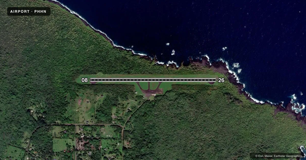
Airport sketch
Runways drawn to scale from FAA survey coordinates, rendered over satellite imagery. Not for navigation.
Approaches & charts
Services on the field
Fuel grades, oxygen, maintenance, ramp storage and lighting — as declared to the FAA by the airport operator.
Fuel & services
- Fuel
- Not available
- Oxygen (bottled)
- Not available
- Oxygen (bulk)
- Not available
- Airframe repair
- Not available
- Power plant repair
- Not available
- Other services
- PAJA
Ramp & ground
- Transient storage
- Tie-down
- Landing fee
- No fee published
- Customs
- Not available
- Lighting schedule
- SEE RMK
- Beacon schedule
- SS-SR
- Beacon
- White / Green (civil land)(WG)
- Wind indicator
- Lighted
- Segmented circle
- Yes
Fuel & FBOs
Cheapest 100LL and Jet A on the field and nearby. Always confirm with the FBO before taxi.
Airport notes
Surface conditions, obstructions, local procedures, lighting outages and other notes published with each FAA cycle.
General notes
- LGTD WIND SOCK LCTD RY 08 AND RY 26 END.
- 24 HRS PPR FOR DIVISION 1.1, 1.2, 1.3 EXPLOSIVES AND 4 HRS PPR FOR OTHER HAZARDOUS CARGO IN/OUT OF ARPT CTC (808) 248-4861 OR (808) 872-3880.
- RY 08/26 35 FT TREES ALONG BOTH SIDES OF RY 200 FT FM CNTRLN.
- HELICOPTER PILOT TRAINING MANEUVERS WILL BE CONDUCTED AT THE APCH END OF RY 26 ONLY.
- ULTRALIGHTS ON AND INVOF ARPT.
- WILD BOARS ON AND INVOF ARPT.
- HELICOPTER PARKING ON GRASS INFIELD AREAS BETWEEN RAMP AND RUNWAY.
- PRCHT LNDG AREA ON E INFIELD BTN TWY B AND C.
- FOR CD CTC HONOLULU CONTROL FACILITY AT 808-840-6262.
Lighting notes
- DUSK-DAWN. ACTVT MIRL (ONLY HIGH INTST AVBL) RY 08/26 - CTAF.
Approach & departure obstructions
- 08RY 08 PAPI DALGT OPNS ONLY. RY 08 PAPI OTS INDEFLY.
Other notes
- THIS AIRPORT HAS BEEN SURVEYED BY THE NATIONAL GEODETIC SURVEY.
- <TPA SMALL ACFT 800' MSL. LARGE ACFT 1500' MSL.
- MANAGERHILARY KANUHA, ARPT OPNS/AOM/MAIN PHONE HANA (808) 248-4861.
VFR map & nearby airports
VFR sectional. Tap any ICAO chip to open that airport.
Key facts · PHHN
Answer card- ICAO
- PHHN
- Name
- HANA
- Location
- HANA, HAWAII
- Elevation
- 77.5 ft MSL
- Traffic pattern altitude
- 1,077.5 ft MSL (1,000 AGL)
- Control tower
- Non-towered (use CTAF)
- Total runways
- 1
- Longest runway
- 08/26 · 3,606 ft
- Published ILS approaches
- 0
- Published frequencies
- 1
- Magnetic variation
- 11°
- Current flight rules
- VFR
- Current wind
- 040° at 17 kt
- Favored runway now
- RWY 08
HANA Airport sits in Hana, Hawaii on the east side of Maui. Field elevation is 77.5 ft MSL. The airport has one runway. Runway 08/26 is 3,606 ft long with an asphalt surface. There is no control tower. CTAF is 122.9. No ILS approaches are published here.
Pattern altitude for small aircraft is 800 ft MSL. Pattern altitude for large aircraft is 1,500 ft MSL. Runway 08 has a PAPI listed for dusk to dawn only. The PAPI on 08 is also out of service indefinitely, so verify your visual glide path before you commit to final.
No on-field FBOs are listed in the facts. Contact the airport operator directly before arrival, or call the field on CTAF for current FBO availability. Published remarks also note trees about 35 ft tall along both sides of Runway 08/26, about 200 ft from centerline. Helicopter training maneuvers are conducted at the approach end of Runway 26 only. Helicopter parking is on the grass infield between the ramp and runway. Wild boars are reported on and near the airport, so keep an eye out during taxi and ramp movement.