METAR & TAF PHTO
Current METAR
Observed 19:04Z
PHTO 091904Z AUTO 00000KT 10SM BKN023 BKN033 OVC048 26/23 A3010 RMK AO2 T02560228 TSNO $
- Wind
- 000° @ 0 kt
- Visibility
- 10 SM
- Temp / Dew
- 26°C / 23°C
- Altimeter
- 30.10 inHg
- Clouds
- OVC
- Density alt
- 1,143 ft
- Ceiling
- 2,300 ft AGL
- Rules
- MVFR
Airport info & contacts
Manager on record, flight service, ARTCC, attendance schedule and pattern altitude — published by the FAA and refreshed every 28 days.
Location
- From city
- 2 NM E
- VFR sectional
- HAWAIIAN ISLANDS
- ARTCC
- ZHN · HONOLULU CONTROL FACILITY
- NOTAM facility
- ITO (NOTAM-D)
Airport manager
- Name
- TIFFINIE C SMITH
- Phone
- 808-961-9300
- Address
- AIRPORTS DISTRICT MANAGER, 2450 KEKUANAOA STREET #215, HILO HI 96720
Flight service · Hours
- FSS HNL
- HONOLULU1-800-WX-BRIEF
- Attendance
- 0700-2030
Frequencies
Tap any row to copy the frequency to your clipboard.
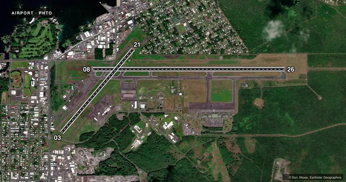
Runways & pattern
Full pagePattern entry · RWY 08
LEFT TRAFFIC| Runway | Heading (°M) | Length | Surface | Traffic |
|---|---|---|---|---|
| 08/26 | 79° / 259° | 9,803 ft | ASPH | Standard L |
| 03/21 | 30° / 210° | 5,601 ft | ASPH | Standard L |
Runway end performance
| End | TORA | TODA | ASDA | LDA | VGSI | Approach lights | Obstruction |
|---|---|---|---|---|---|---|---|
| 08 | 9,803' | 9,803' | 9,803' | 9,803' | PAPI 4-box right(3°) | ODALS | 32', tree, 1400' from thr, 600' R of cntrln, slope 43 |
| 26 | 9,803' | 9,803' | 9,803' | 9,803' | PAPI 4-box left(2.6°) | MALSR | 25', tree, 650' from thr, 400' R of cntrln, slope 26 |
| 03 | 5,192' | 5,192' | 5,601' | 5,250' | VASI 4-box left(3.25°) | — | 7', fence, 200' from thr, 0' R of cntrln, slope 0 |
| 21 | 5,250' | 5,250' | 5,510' | 5,510' | — | — | 37', pole, 1050' from thr, 20' R of cntrln, slope 28 |
Declared distances in feet. TORA = takeoff run available, TODA = takeoff distance, ASDA = accelerate-stop, LDA = landing distance.
Airport sketch
Runways drawn to scale from FAA survey coordinates, rendered over satellite imagery. Not for navigation.
Approaches & charts
ILS · 1
Services on the field
Fuel grades, oxygen, maintenance, ramp storage and lighting — as declared to the FAA by the airport operator.
Fuel & services
- Fuel
- 100LLAA+MOGAS
- Oxygen (bottled)
- Not available
- Oxygen (bulk)
- Not available
- Airframe repair
- Minor
- Power plant repair
- Not available
- Other services
- AFRT,AGRI,CARGO,CHTR,INSTR,RNTL
Ramp & ground
- Transient storage
- Tie-down
- Landing fee
- Yes
- Customs
- Not available
- Lighting schedule
- SEE RMK
- Beacon schedule
- SS-SR
- Beacon
- White / Green (civil land)(WG)
- Wind indicator
- Lighted
- Segmented circle
- Yes
Fuel & FBOs
Cheapest 100LL and Jet A on the field and nearby. Always confirm with the FBO before taxi.
Airport notes
Surface conditions, obstructions, local procedures, lighting outages and other notes published with each FAA cycle.
General notes
- RWY 08 PVD 1325' MKD BY CHEVRONS, UNUSBL FOR LNDG/TKOF/OVRN/STY; CANNOT BE USED IN COMPUTING TKOF DATA.
- ATCT CTLS ENTRY/EXIT TFC ON TWYS F&E TO EAST TRML RAMP.
- 181' LGTD SMOKE STACK 1/2 SM SOUTH OF FLD.
- PPR FROM ARPT MGR FOR TRANSIENT PARKING.
- BE ALERT OCNL BIRD FLOCKS ON ARPT AND IN FLT ACROSS RWY 08/26 AND 03/21.
- (A70A) JET FUEL AVBL MON-SAT 0800-1700 CALL (808) 935-6881/6122 OR 961-6601.
- (E93) NO MKD PAD, HEL OPER FM FBO HANGER AREA.
- DIVISION 1.1, 1.2, 1.3 EXPLOSIVES PROHIBITED.
- PPR FROM AIRPORT MANAGER FOR TRANSPORTATION OF DIVISION 1.4 EXPLOSIVES AND HAZARDOUS MATERIAL IN OR OUT OF AIRPORT.
- NOISE ABATEMENT: AVOID OVERFLIGHT OF NOISE SENSITIVE RESIDENTIAL AREAS N, W AND SW OF AIRPORT.
- RY 08/26 SINGLE-BELLY TWIN TANDEM (SBTT) GWT 450,000 LBS.
- RY 03/21 SINGLE-BELLY TWIN TANDEM (SBTT) GWT 230,000 LBS.
- FOR CD WHEN ATCT IS CLSD CTC HONOLULU CONTROL FACILITY AT 808-840-6262.
- TWY E BTN TWY A AND RWY 08/26 PONDING DRG HVY RAINS.
- RWYS 8, 21 AND 26 WIND CONES ARE LCTD IN THE ROFA.
Lighting notes
- DUSK-DAWN. ACTVT MIRL RY 03/21 & HIRL RY 08/26; MALSR RY 26 & ODALS RY 08 - 118.1.
Fuel notes
- 100LLFOR FUEL ADVANCE NOTICE REQUIRED, FOR 100LL CALL (808) 960-5146 OR CTC FREQ 128.95, FOR JET-A CALL (808) 934-7757 OR CTC FREQ 130.8.
Runway surface & condition
- 03/21PCR VALUE: 180/F/B/X/T
- 08/26PCR VALUE: 390/F/B/X/T
Approach & departure obstructions
- 08+6' FENCES 400' LEFT OF CNTRLN.
- 08PAPI RWY 08 UNUSBL BYD 3.0 NM
- 03APCH RATIO 20:1 FM DSPLCD THR.
Other notes
- ARFF AVBL 24 HRS, CONTACT 118.1 OR 808-961-9317.
- MANAGERHAWAII DIST MGR CHAUNCEY WONG YUEN AT KEAHOLE ARPT 808-327-9520 EXT 222.
VFR map & nearby airports
VFR sectional. Tap any ICAO chip to open that airport.
Key facts · PHTO
Answer card- ICAO
- PHTO
- Name
- HILO INTL
- Location
- HILO, HAWAII
- Elevation
- 37.6 ft MSL
- Traffic pattern altitude
- 1,037.6 ft MSL (1,000 AGL)
- Control tower
- Towered · 0600-2200
- Total runways
- 2
- Longest runway
- 08/26 · 9,803 ft
- Published ILS approaches
- 1
- Published frequencies
- 11
- Magnetic variation
- 11°
- Current flight rules
- MVFR
- Current wind
- 000° at 0 kt
- Favored runway now
- –
Hilo Intl sits in Hilo, Hawaii on the Big Island. Field elevation is 37.6 ft MSL. The airport has 2 asphalt runways. The longest is 08/26 at 9,803 ft. The control tower is open 0600-2200. One ILS is published for runway 26. Pattern altitude is not published, so use the standard 1,000 ft AGL for light piston traffic unless ATC or the current FAA Chart Supplement says otherwise.
This is a busy coastal airport with a few things that matter on first arrival. Noise abatement calls for avoiding overflight of residential areas north, west and southwest of the field. Bird activity is also called out in the remarks, so keep a sharp scan on approach and departure. Runway 08 has 1,325 ft marked by chevrons and is unusable for landing, takeoff, overrun, or stopway. The airport also notes that runway 03/21 can support very heavy single-belly twin tandem aircraft. For lighting, runway 03/21 uses medium intensity runway lights from dusk to dawn. Runway 08/26 uses high intensity runway lights, with approach lighting on both ends. Signature Aviation is on the field for Jet-A. Atlantic Aviation is on the field for AVGAS 100LL and Jet-A.