METAR & TAF PAHO
Current METAR
Observed 03:53Z
PAHO 280353Z 24009KT 10SM OVC085 13/08 A3000 RMK AO2 SLP159 T01330083
- Wind
- 240° @ 9 kt
- Visibility
- 10 SM
- Temp / Dew
- 13°C / 8°C
- Altimeter
- 30.00 inHg
- Clouds
- OVC
- Density alt
- -235 ft
- Ceiling
- 8,500 ft AGL
- Rules
- VFR
Airport info & contacts
Manager on record, flight service, ARTCC, attendance schedule and pattern altitude — published by the FAA and refreshed every 28 days.
Location
- From city
- 2 NM E
- VFR sectional
- SEWARD
- Pattern altitude
- 800 ft AGL · 884 ft MSL
- ARTCC
- ZAN · ANCHORAGE
- NOTAM facility
- HOM (NOTAM-D)
Airport manager
- Name
- MATTHEW BLAINE
- Phone
- 907-235-4394
- Address
- 2320 KACHEMAK DR, HOMER AK 99603
Flight service · Hours
- FSS HOM
- HOMER907-235-8588LC235-8588
- Attendance
- NOV-MAR · 0400-2100
- APR-OCT · 0600-2100
Frequencies
Tap any row to copy the frequency to your clipboard.
Runways & pattern
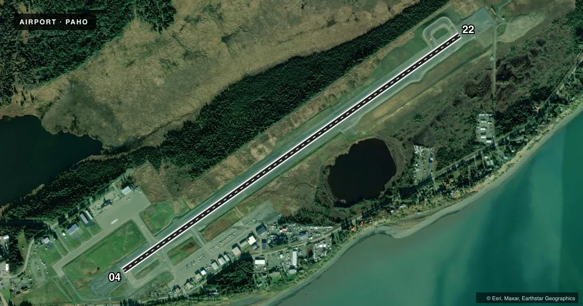
Full pagePattern entry · RWY 22
LEFT TRAFFICRunway end performance
| End | TORA | TODA | ASDA | LDA | VGSI | Approach lights | Obstruction |
|---|---|---|---|---|---|---|---|
| 04 | — | — | — | — | PAPI 4-box left(3°) | MALSF | 31', ant, 522' from thr, 520' R of cntrln, slope 10 |
| 22 | — | — | — | — | PAPI 4-box left(3°) | MALSR | 74', tree, 2269' from thr, 425' R of cntrln, slope 27 |
Declared distances in feet. TORA = takeoff run available, TODA = takeoff distance, ASDA = accelerate-stop, LDA = landing distance.
Airport sketch
Runways drawn to scale from FAA survey coordinates, rendered over satellite imagery. Not for navigation.
Approaches & charts
ILS · 1
Services on the field
Fuel grades, oxygen, maintenance, ramp storage and lighting — as declared to the FAA by the airport operator.
Fuel & services
- Fuel
- 100LLA
- Airframe repair
- Minor
- Power plant repair
- Minor
- Other services
- CARGO
Ramp & ground
- Transient storage
- Tie-down
- Hangar
- Landing fee
- No fee published
- Customs
- Not available
- Lighting schedule
- SEE RMK
- Beacon schedule
- SS-SR
- Beacon
- White / Green (civil land)(WG)
- Wind indicator
- Lighted
- Segmented circle
- Yes
Fuel & FBOs
Cheapest 100LL and Jet A on the field and nearby. Always confirm with the FBO before taxi.
Airport notes
Surface conditions, obstructions, local procedures, lighting outages and other notes published with each FAA cycle.
General notes
- SEA BIRDS & WATER FOWL ON & INVOF ARPT DURG SPRING & SUMMER.
- GA TSNT PRKG S SIDE OF RWY.
- GRVL ROAD S SIDE OF RWY CLSD TO ACFT; TAX NA.
- 365 FT UNLGT TWR 9 NM W.
- PAEW MAY BE ON RWY H24.
- TPA 800 FT AGL FOR FIXED WING ACFT; TPA 600 FT AGL & BLO FOR ROTARY ACFT.
- RWY COND, SNOW/ICE RPRT & REMOVAL, WILDLIFE CTL OR OTR SVC AVBL DURG SKED MAINT HR; AFT HR SVC - AMGR.
- TWY D CLSD; TWY A, B SOUTH & E CLSD TO ACFT OVR 12500 LB.
- SAND GRADATION LRGR THAN FAA RCMDD; SEE AC150/5200-30.
- WX CAMERA AVBL ON INTERNET AT HTTP://WEATHERCAMS.FAA.GOV.
- NOISE ABATEMENT IN EFCT H24; TURNS BFR DEP END RWY 04/22 NA AT HOMER & SPB; RPRT OBS DEV TO FAA SAFETY HOTLINE.
Lighting notes
- ACTVT MALSF RWY 04; MALSR RWY 22; PAPI RWY 04 & 22; HIRL RWY 04/22 - CTAF.
Runway surface & condition
- 04/22PCR VALUE: 511/F/A/X/T
- 04/22LINE OF SIGHT BTN RWY ENDS NA.
Other notes
- DURG ACR OPS ONLY.
- PPR FOR ACR OPS MORE THAN 30 PAX SEATS IN WRITING - AMGR: 2320 KACHEMAK DR. HOMER; AK 99603.
VFR map & nearby airports
VFR sectional. Tap any ICAO chip to open that airport.
Key facts · PAHO
Answer card- ICAO
- PAHO
- Name
- HOMER
- Location
- HOMER, ALASKA
- Elevation
- 84.3 ft MSL
- Traffic pattern altitude
- 884.3 ft MSL (800 AGL)
- Control tower
- Non-towered (use CTAF)
- Total runways
- 1
- Longest runway
- 04/22 · 6,701 ft
- Published ILS approaches
- 1
- Published frequencies
- 1
- Magnetic variation
- 17°
- Current flight rules
- VFR
- Current wind
- 240° at 9 kt
- Favored runway now
- RWY 22
Homer Airport is in Homer, Alaska. The field elevation is 84.3 ft MSL. It has one runway, 04/22, which is 6,701 ft long. There is no control tower. CTAF is 123.6.
An ILS is available to runway 04. The runway lighting setup includes medium intensity approach lights with sequenced flashers on 04. Runway 22 has medium intensity approach lights with runway alignment indicator lights. Both ends have precision approach path indicators. Both ends also have high intensity runway lights. Use CTAF for lighting or airport coordination.
Pattern altitude is 800 ft AGL for fixed wing aircraft. That is 884.3 ft MSL. Rotary pattern altitude is 600 ft AGL and below. The airport sits in coastal Alaska, so expect weather, wind and bird activity to matter. Sea birds and water fowl are reported on and near the field during spring and summer. Noise abatement is in effect 24 hours a day. Turns before the departure end of runway 04/22 are not authorized.
Maritime Helicopters is on the field and carries JET_A. Kachemak Jet Center is also on the field and carries JET_A and JET_A_PRIST. For larger aircraft, prior permission in writing is required for operations with more than 30 passenger seats. Check current runway condition and service status before arrival. Snow and ice reports, wildlife control and other services are tied to scheduled maintenance hours or the airport manager after hours.