METAR & TAF PAAW
PAAW does not publish a METAR.
Showing the nearest reporting station: PASO (SELDOVIA) · 8.7 NM away. Conditions at PAAW may differ.
METAR · PASO
Observed 07:13Z
PASO 250713Z AUTO 00000KT 10SM SCT024 SCT048 BKN060 09/07 A2996 RMK AO2 T00890072 TSNO
- Wind
- 000° @ 0 kt
- Visibility
- 10 SM
- Temp / Dew
- 9°C / 7°C
- Altimeter
- 29.96 inHg
- Clouds
- BKN
- Density alt
- -736 ft
- Ceiling
- 6,000 ft AGL
- Rules
- VFR
Airport info & contacts
Manager on record, flight service, ARTCC, attendance schedule and pattern altitude — published by the FAA and refreshed every 28 days.
Location
- From city
- 0 NM SW
- VFR sectional
- KODIAK
- ARTCC
- ZAN · ANCHORAGE
- NOTAM facility
- HOM (NOTAM-D)
Airport manager
- Name
- KEVIN JONES
- Phone
- 907-235-5217
- Address
- 2320 KACHEMAK DR, HOMER AK 99603
Flight service · Hours
- FSS HOM
- HOMER907-235-8588LC235-8588
- Attendance
- Unattended
Frequencies
Tap any row to copy the frequency to your clipboard.
Runways & pattern
Full pagePattern entry · RWY 01
LEFT TRAFFICRunway end performance
| End | TORA | TODA | ASDA | LDA | VGSI | Approach lights | Obstruction |
|---|---|---|---|---|---|---|---|
| 01 | — | — | — | — | — | — | 4', brush, 0' from thr, 0' R of cntrln, slope 0 |
| 19 | — | — | — | — | — | — | 6', brush, 0' from thr, 0' R of cntrln, slope 3 |
Declared distances in feet. TORA = takeoff run available, TODA = takeoff distance, ASDA = accelerate-stop, LDA = landing distance.
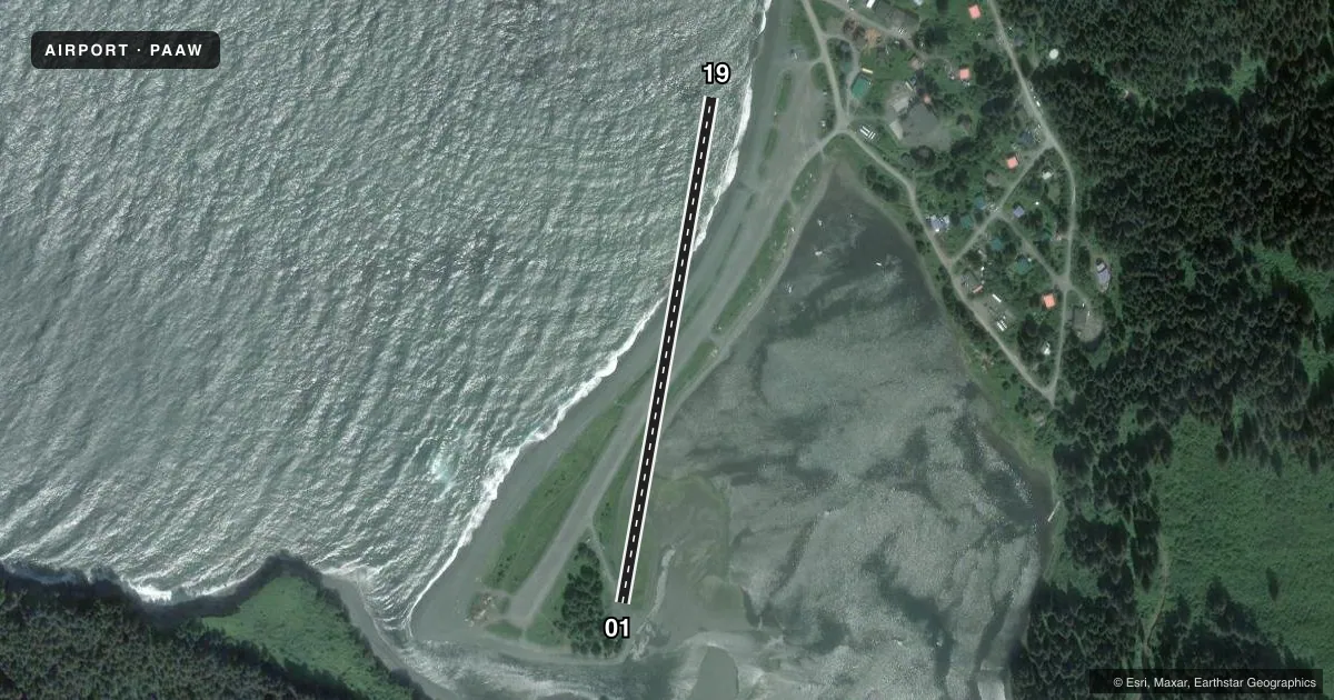
Airport sketch
Runways drawn to scale from FAA survey coordinates, rendered over satellite imagery. Not for navigation.
Approaches & charts
Services on the field
Fuel grades, oxygen, maintenance, ramp storage and lighting — as declared to the FAA by the airport operator.
Fuel & services
- Fuel
- Not available
Ramp & ground
- Transient storage
- Not published
- Landing fee
- No fee published
- Customs
- Not available
- Wind indicator
- Yes
- Segmented circle
- No
Fuel & FBOs
Cheapest 100LL and Jet A on the field and nearby. Always confirm with the FBO before taxi.
Airport notes
Surface conditions, obstructions, local procedures, lighting outages and other notes published with each FAA cycle.
General notes
- LMTD TNST PRKG.
- DAY VFR ONLY.
- ATV TFC ON RWY.
- BE ALERT DURG E CROSSWIND; EXP DOWNDRAFTS & GUSTY CONDS.
- WX CAMERA AVBL ON INTERNET AT HTTPS://WEATHERCAMS.FAA.GOV
- RWY COND UNMNT: RCMD VISUAL INSP BFR USE.
Runway surface & condition
- 01/19EXP TURB; VRBL WINDS & CLOSE IN HIGH TRRN BOTH ENDS. ARC SHAPED RWY; MAG HDG 10 DEG ONE END & HDG 190 DEGS OTR END.
- 01/19N 1000 FT CLSD INDEFLY; RMNDR 850 FT SOFT.
- 01/19VRBL BTN 75-80 FT FULL LEN.
Approach & departure obstructions
- 19RISING TRRN & TREES E SIDE.
- 01APCH RSTRD BY MT FACE 0.21 NM FM END.
- 19APCH RSTRD BY VILLAGE ON HILLSIDE. NO OVRN.
Other notes
- RWY 01 WIND SOCK NA.
- MANAGER907-235-5217.
- 01/19SOFT AFT RAIN; RUTS & LOOSE ROCK.
VFR map & nearby airports
VFR sectional. Tap any ICAO chip to open that airport.
Key facts · PAAW
Answer card- ICAO
- PAAW
- Name
- NANWALEK
- Location
- NANWALEK, ALASKA
- Elevation
- 27 ft MSL
- Traffic pattern altitude
- 1,027 ft MSL (1,000 AGL)
- Control tower
- Non-towered (use CTAF)
- Total runways
- 1
- Longest runway
- 01/19 · 1,850 ft
- Published ILS approaches
- 0
- Published frequencies
- 1
- Magnetic variation
- 23°
- Current flight rules
- VFR
- Current wind
- 000° at 0 kt
- Favored runway now
- –