METAR & TAF PGM
PGM does not publish a METAR.
Showing the nearest reporting station: PASO (SELDOVIA) · 6.9 NM away. Conditions at PGM may differ.
METAR · PASO
Observed 03:53Z
PASO 280353Z AUTO 21005KT 10SM SCT032 OVC065 15/08 A2999 RMK AO2 SLP157 T01500078 TSNO $
- Wind
- 210° @ 5 kt
- Visibility
- 10 SM
- Temp / Dew
- 15°C / 8°C
- Altimeter
- 29.99 inHg
- Clouds
- OVC
- Density alt
- 29 ft
- Ceiling
- 6,500 ft AGL
- Rules
- VFR
Airport info & contacts
Manager on record, flight service, ARTCC, attendance schedule and pattern altitude — published by the FAA and refreshed every 28 days.
Location
- From city
- 0 NM W
- VFR sectional
- KODIAK
- ARTCC
- ZAN · ANCHORAGE
- NOTAM facility
- HOM (NOTAM-D)
Airport manager
- Name
- KEVIN JONES
- Phone
- 907-235-5217
- Address
- 2320 KACHEMAK DR, HOMER AK 99603
Flight service · Hours
- FSS HOM
- HOMER907-235-8588LC235-8588
- Attendance
- Unattended
Frequencies
Tap any row to copy the frequency to your clipboard.
Runways & pattern
Full pagePattern entry · RWY 12
LEFT TRAFFICRunway end performance
| End | TORA | TODA | ASDA | LDA | VGSI | Approach lights | Obstruction |
|---|---|---|---|---|---|---|---|
| 12 | — | — | — | — | — | — | 15', road, 0' from thr, 120' R of cntrln, slope 0 |
| 30 | — | — | — | — | — | — | 15', brush, 0' from thr, 56' R of cntrln, slope 0 |
Declared distances in feet. TORA = takeoff run available, TODA = takeoff distance, ASDA = accelerate-stop, LDA = landing distance.
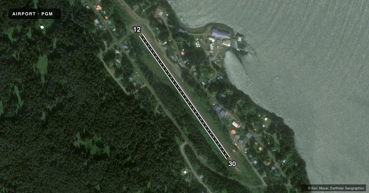
Airport sketch
Runways drawn to scale from FAA survey coordinates, rendered over satellite imagery. Not for navigation.
Approaches & charts
Services on the field
Fuel grades, oxygen, maintenance, ramp storage and lighting — as declared to the FAA by the airport operator.
Fuel & services
- Fuel
- Not available
- Oxygen (bottled)
- Not available
- Oxygen (bulk)
- Not available
- Airframe repair
- Not available
- Power plant repair
- Not available
Ramp & ground
- Transient storage
- Not published
- Landing fee
- No fee published
- Customs
- Not available
- Wind indicator
- Yes
- Segmented circle
- No
Fuel & FBOs
Cheapest 100LL and Jet A on the field and nearby. Always confirm with the FBO before taxi.
Airport notes
Surface conditions, obstructions, local procedures, lighting outages and other notes published with each FAA cycle.
General notes
- RWY NOT REGULARLY ATNDD BY MAINT PSNL; RECOMMEND VISUAL INSPECTION PRIOR TO USE.
- WATCH FOR CHILDREN AND DOGS ON RWY.
- TREES PENETRATE PART-77 TRANSITIONAL & APCH SURFACES.
- RWY30 DEVELOPS FROST HEAVES FIRST 300 FT & RWY12 FIRST 500 FT DURG WINTER.
- RWY DIPS IN CENTER & RY EDGES SOFT DURG SPRING MONTHS.
- RWY EDGES SOFT DURING BREAKUP.
- ROAD 150 FT FM APCH END OF RWY 12.
- TWR .04NM NE OF ARPT UNLGTD.
Approach & departure obstructions
- 12RWY 12/30 MKD WITH REFLECTIVE CONES.
- 12OBSTRUCTION IS ABEAM RUNWAY THR.
- 12TOWER (80FT AGL), UNLIGHTED, 59.21.3.90N, 151.49.57.10W, (.03NM NE RW12 THR).
Other notes
- MANAGER907-235-5217.
- 12/30SCATTERED SHARP EDGE ROCKS TO 3 INCHES ON RWY.
VFR map & nearby airports
VFR sectional. Tap any ICAO chip to open that airport.
Key facts · PGM
Answer card- ICAO
- PGM
- Name
- PORT GRAHAM
- Location
- PORT GRAHAM, ALASKA
- Elevation
- 93 ft MSL
- Traffic pattern altitude
- 1,093 ft MSL (1,000 AGL)
- Control tower
- Non-towered (use CTAF)
- Total runways
- 1
- Longest runway
- 12/30 · 1,975 ft
- Published ILS approaches
- 0
- Published frequencies
- 1
- Magnetic variation
- 23°
- Current flight rules
- VFR
- Current wind
- 210° at 5 kt
- Favored runway now
- RWY 12
Port Graham Airport (PGM) sits in Port Graham, Alaska. Field elevation is 93 ft MSL. The airport has one runway. Runway 12/30 is 1,975 ft long with a gravel-dirt surface. There is no control tower. CTAF is 122.9.
No ILS approaches are published here. Pattern altitude is not published, so use the standard 1,000 ft AGL unless the current FAA Chart Supplement says otherwise. That puts the light piston pattern at 1,093 ft MSL based on the field elevation. The runway is marked with reflective cones. Published remarks also call out soft edges during breakup, a center dip in the runway, scattered sharp rocks up to 3 inches and frost heaves in the first 300 ft of runway 30 and the first 500 ft of runway 12 during winter. Trees penetrate the Part 77 transitional and approach surfaces. There is also an unlighted tower near the airport. Visual inspection before use is a good idea here. Watch for children and dogs on the runway.
There are no on-field FBOs listed. Check the current FAA Chart Supplement or call the airport operator before you go. In this part of Alaska, runway condition and surface softness matter more than the charted length on paper.