METAR & TAF PAGA
Current METAR
Observed 06:56Z
PAGA 280656Z AUTO 25013KT 5SM RA BR OVC005 13/12 A2979
- Wind
- 250° @ 13 kt
- Visibility
- 5 SM
- Temp / Dew
- 13°C / 12°C
- Altimeter
- 29.79 inHg
- Clouds
- OVC
- Density alt
- 112 ft
- Ceiling
- 500 ft AGL
- Rules
- IFR
Airport info & contacts
Manager on record, flight service, ARTCC, attendance schedule and pattern altitude — published by the FAA and refreshed every 28 days.
Location
- From city
- 0 NM NW
- VFR sectional
- FAIRBANKS
- ARTCC
- ZAN · ANCHORAGE
- NOTAM facility
- GAL (NOTAM-D)
Airport manager
- Name
- JASON LUDINGTON
- Phone
- 907-451-5280
- Address
- BOX 9, GALENA AK 99741
Flight service · Hours
- FSS FAI
- FAIRBANKS907-474-07881-866-248-6516
- Attendance
- OCT-APR · MON-FRI · 0600-1700
Frequencies
Tap any row to copy the frequency to your clipboard.
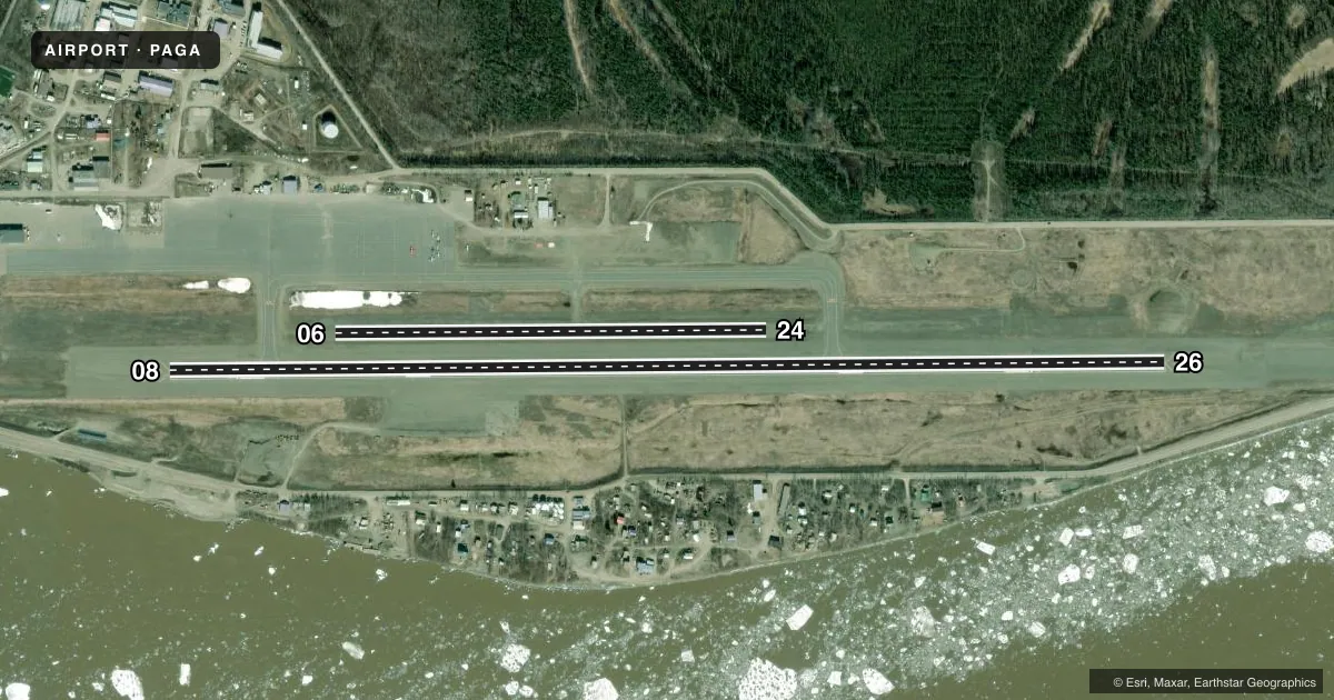
Runways & pattern
Full pagePattern entry · RWY 26
LEFT TRAFFIC| Runway | Heading (°M) | Length | Surface | Traffic |
|---|---|---|---|---|
| 08/26Favored | 77° / 257° | 6,000 ft | ASPH | Standard L |
| 06/24 | 77° / 257° | 2,600 ft | GRAVEL | Standard L |
Runway end performance
| End | TORA | TODA | ASDA | LDA | VGSI | Approach lights | Obstruction |
|---|---|---|---|---|---|---|---|
| 08 | 6,000' | 6,000' | 6,000' | 5,600' | — | — | — |
| 26 | 6,000' | 6,000' | 6,000' | 5,200' | — | — | 33', road, 447' from thr, 446' R of cntrln, slope 7 |
Declared distances in feet. TORA = takeoff run available, TODA = takeoff distance, ASDA = accelerate-stop, LDA = landing distance.
Airport sketch
Runways drawn to scale from FAA survey coordinates, rendered over satellite imagery. Not for navigation.
Approaches & charts
Services on the field
Fuel grades, oxygen, maintenance, ramp storage and lighting — as declared to the FAA by the airport operator.
Fuel & services
- Fuel
- 100LLA
- Other services
- CARGO
Ramp & ground
- Transient storage
- Tie-down
- Hangar
- Landing fee
- Yes
- Customs
- Not available
- Lighting schedule
- SEE RMK
- Beacon schedule
- SS-SR
- Beacon
- White / Green (civil land)(WG)
- Wind indicator
- Yes
- Segmented circle
- Yes
Fuel & FBOs
Cheapest 100LL and Jet A on the field and nearby. Always confirm with the FBO before taxi.
Airport notes
Surface conditions, obstructions, local procedures, lighting outages and other notes published with each FAA cycle.
General notes
- MAINT HRS 0800-1600 MON-FRI EXCP HOLS.
- HAZUS RPRTG DURG DUTY HR UNLESS PRIOR ARNGMT IN WRITING - AMGR, PO BOX 09, GALENA AK 99741.
- SNOW REMOVAL OPS - MONITOR CTAF.
- ACFT MAY BE CLOSER TO LNDG SFC THAN IT APPEARS.
- ULTRALIGHTS ON & INVOF ARPT.
- WX CAMERA AVBL ON INTERNET AT HTTPS://WEATHERCAMS.FAA.GOV.
- FUEL AVBL MON-FRI 0800-1700; AFT HR CALL OUT FEE - 907-656-1852.
Lighting notes
- ACTVT MIRL RWY 08/26 - CTAF.
Runway surface & condition
- 08/26WS PSBL BLW 2000 FT ON FNL.
Other notes
- PAY PHONE AVAILABLE.
- MANAGERLCTD FAIRBANKS.
VFR map & nearby airports
VFR sectional. Tap any ICAO chip to open that airport.
Key facts · PAGA
Answer card- ICAO
- PAGA
- Name
- EDWARD G PITKA SR
- Location
- GALENA, ALASKA
- Elevation
- 153.7 ft MSL
- Traffic pattern altitude
- 1,153.7 ft MSL (1,000 AGL)
- Control tower
- Non-towered (use CTAF)
- Total runways
- 2
- Longest runway
- 08/26 · 6,000 ft
- Published ILS approaches
- 0
- Published frequencies
- 1
- Magnetic variation
- 13°
- Current flight rules
- IFR
- Current wind
- 250° at 13 kt
- Favored runway now
- RWY 26
Edward G Pitka Sr Airport serves Galena, Alaska. The field elevation is 153.7 ft MSL. It has two runways. The longest is 6,000 ft on 08/26. The airport is non-towered, so CTAF 123.0 is the key frequency for traffic calls and for runway 08/26 lighting activation. No ILS approaches are published here.
The published pattern altitude is not listed. Use the standard 1,000 ft AGL pattern unless local procedures or the current Chart Supplement say otherwise. Crowley Aviation Fuels is on the field. It carries 100LL and Jet A. Call ahead if you need fuel after hours. Published remarks say fuel is available Monday through Friday from 0800 to 1700. After hours, a fee applies. Snow removal is active, so monitor CTAF for airport vehicle movement. Windshear is possible below 2,000 ft on final to 08/26. Ultralight aircraft also operate in and around the airport.
This is a practical Alaska field. Watch the weather closely. A weather camera is available online. Aircraft may be closer to the landing surface than it appears, so keep that in mind on short final. If you are carrying hazardous materials, check the duty-hour reporting requirement before arrival. The airport manager is based in Fairbanks, so plan ahead if you need special coordination.