METAR & TAF KVNC
Current METAR
Observed 20:15Z
KVNC 272015Z AUTO 33010KT 10SM SCT120 SCT360 28/23 A2991 RMK AO2 RAE1958 P0000 T02790230 $
- Wind
- 330° @ 10 kt
- Visibility
- 10 SM
- Temp / Dew
- 28°C / 23°C
- Altimeter
- 29.91 inHg
- Clouds
- SCT
- Density alt
- 1,595 ft
- Ceiling
- Unlimited
- Rules
- VFR
Airport info & contacts
Manager on record, flight service, ARTCC, attendance schedule and pattern altitude — published by the FAA and refreshed every 28 days.
Location
- From city
- 2 NM S
- VFR sectional
- MIAMI
- ARTCC
- ZMA · MIAMI
- NOTAM facility
- PIE (NOTAM-D)
Airport manager
- Name
- NICHOLAS DUMAS
- Phone
- 941-486-2711
- Address
- 150 AIRPORT AVE EAST, VENICE FL 34285
Flight service · Hours
- FSS PIE
- SAINT PETERSBURG1-800-WX-BRIEF
- Attendance
- 0700-1900
Frequencies
Tap any row to copy the frequency to your clipboard.
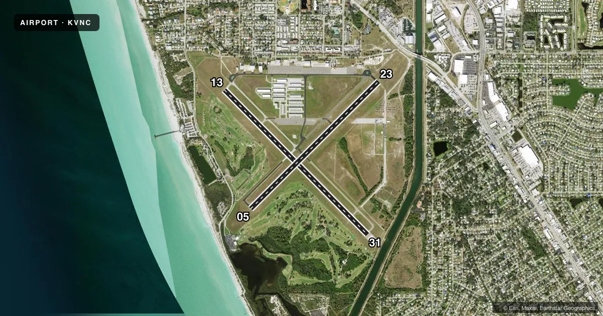
Runways & pattern
Full pagePattern entry · RWY 31
LEFT TRAFFIC| Runway | Heading (°M) | Length | Surface | Traffic |
|---|---|---|---|---|
| 13/31Favored | 130° / 310° | 5,640 ft | ASPH | 13 R |
| 05/23 | 40° / 220° | 5,000 ft | ASPH | Standard L |
Runway end performance
| End | TORA | TODA | ASDA | LDA | VGSI | Approach lights | Obstruction |
|---|---|---|---|---|---|---|---|
| 13 | 5,000' | 5,000' | 5,000' | 5,000' | PAPI 4-box left(3°) | — | 40', trees, 1155' from thr, 255' R of cntrln, slope 23 |
| 31 | 5,000' | 5,000' | 5,000' | 5,000' | PAPI 4-box left(3°) | — | 45', tree, 890' from thr, 110' R of cntrln, slope 15 |
| 05 | — | — | — | — | PAPI 4-box left(3°) | — | 14', trees, 865' from thr, 225' R of cntrln, slope 50 |
| 23 | 5,000' | 5,000' | 4,840' | 4,377' | PAPI 4-box left(3°) | — | 55', brdg, 1190' from thr, 90' R of cntrln, slope 18 |
Declared distances in feet. TORA = takeoff run available, TODA = takeoff distance, ASDA = accelerate-stop, LDA = landing distance.
Airport sketch
Runways drawn to scale from FAA survey coordinates, rendered over satellite imagery. Not for navigation.
Approaches & charts
Services on the field
Fuel grades, oxygen, maintenance, ramp storage and lighting — as declared to the FAA by the airport operator.
Fuel & services
- Fuel
- 100LLA
- Oxygen (bottled)
- Not available
- Oxygen (bulk)
- Not available
- Airframe repair
- Major
- Power plant repair
- Major
- Other services
- AVNCS,CHTR,INSTR,RNTL,SALES
Ramp & ground
- Transient storage
- Tie-down
- Hangar
- Landing fee
- No fee published
- Customs
- Not available
- Lighting schedule
- SEE RMK
- Beacon schedule
- SS-SR
- Beacon
- White / Green (civil land)(WG)
- Wind indicator
- Lighted
Fuel & FBOs
Cheapest 100LL and Jet A on the field and nearby. Always confirm with the FBO before taxi.
Airport notes
Surface conditions, obstructions, local procedures, lighting outages and other notes published with each FAA cycle.
General notes
- ARPT HAS EXTENSIVE FLIGHT TRAINING.
- BIRD AND WILDLIFE ON AND INVOF THE ARPT.
- PAEW ADJ TO ALL RYS AND TWYS DURG DALGT HRS.
- PPR FOR ACFT EXCEEDING RY WEIGHT BEARING CAPACITY.
- PARASAILING ACTIVITY WEST THE ARPT ALONG BEACH.
- RY 23 IS CALM WIND RY.
- NOISE ABATEMENT PROCEDURES IN EFFECT, CALL AMGR 941-486-2711.
- ARPT SFC CONDS NOT RPRTD.
- FOR CD CTC TAMPA APCH AT 813-878-2528
- 24 HR PPR FOR ACFT EQUIPPED WITH WEATHER MODIFICATION OR GEOENGINEERING EQPT 941-486-2711.
Lighting notes
- ACTVT REIL RWY 5, 23, & 13; MIRL RWY 5/23, 13/31 - CTAF.
Approach & departure obstructions
- 05RWY 05/23 PREF APCH.
- 23PREF DEP CALM WIND RWY.
- 13RWY 13 APCH SLOPE 45:1 TO DTHR.
- 23RWY 23 APCH RATIO 30:1 TO DTHR.
- 31RWY 31 APCH SLOPE 34:1 TO DTHR.
Arresting gear
- 13_EMASENGINEERED MATERIAL ARRESTING SYSTEM 260 FT IN LENGTH BY 165 FT IN WIDTH LCTD AT THE DER 13.
VFR map & nearby airports
VFR sectional. Tap any ICAO chip to open that airport.
Key facts · KVNC
Answer card- ICAO
- KVNC
- Name
- VENICE MUNI
- Location
- VENICE, FLORIDA
- Elevation
- 18.1 ft MSL
- Traffic pattern altitude
- 1,018.1 ft MSL (1,000 AGL)
- Control tower
- Non-towered (use CTAF)
- Total runways
- 2
- Longest runway
- 13/31 · 5,640 ft
- Published ILS approaches
- 0
- Published frequencies
- 6
- Magnetic variation
- 5°
- Current flight rules
- VFR
- Current wind
- 330° at 10 kt
- Favored runway now
- RWY 31
Venice Muni is in Venice, Florida. Field elevation is 18.1 ft MSL. The airport has two asphalt runways. The longest is 5,640 ft on runway 13/31. There is no control tower. CTAF and UNICOM are 122.725. Approach and departure service is handled by Tampa on the published frequencies.
No ILS approaches are published here. Pattern altitude is not published in the facts. Use the current Chart Supplement before you fly the pattern. The field has extensive flight training. Expect a busy local pattern. Runway 23 is published as the calm wind runway. Noise abatement procedures are in effect. Call the airport manager at 941-486-2711 for current guidance.
Skyport Aviation is on the field. It carries 100LL, Jet A and Jet A Prist. The airport also has an EMAS area at the departure end of runway 13. Runway 23 has a displaced-threshold approach note. Runway 13 has its own approach slope note. Parasailing occurs west of the airport along the beach. Bird and wildlife activity is also reported in the area. If you are new to KVNC, plan for a non-towered airport with training traffic, published lighting on the runways and a field that can feel active even outside peak hours.