METAR & TAF KVGT
Current METAR
Observed 10:53Z
KVGT 271053Z AUTO 18007KT 10SM CLR 34/08 A2986 RMK AO2 SLP090 T03440083
- Wind
- 180° @ 7 kt
- Visibility
- 10 SM
- Temp / Dew
- 34°C / 8°C
- Altimeter
- 29.86 inHg
- Clouds
- CLR
- Density alt
- 5,089 ft
- Ceiling
- Unlimited
- Rules
- VFR
Airport info & contacts
Manager on record, flight service, ARTCC, attendance schedule and pattern altitude — published by the FAA and refreshed every 28 days.
Location
- From city
- 3 NM NW
- VFR sectional
- LAS VEGAS
- Pattern altitude
- 800 ft AGL · 3,005 ft MSL
- ARTCC
- ZLA · LOS ANGELES
- NOTAM facility
- VGT (NOTAM-D)
Airport manager
- Name
- KARINA TARNOWSKA
- Phone
- 702-261-3804
- Address
- 2730 AIRPORT DR SUITE 101, NORTH LAS VEGAS NV 89032
Flight service · Hours
- FSS RNO
- RENO1-800-WX-BRIEF
- Attendance
- 0500-2230
Frequencies
Tap any row to copy the frequency to your clipboard.
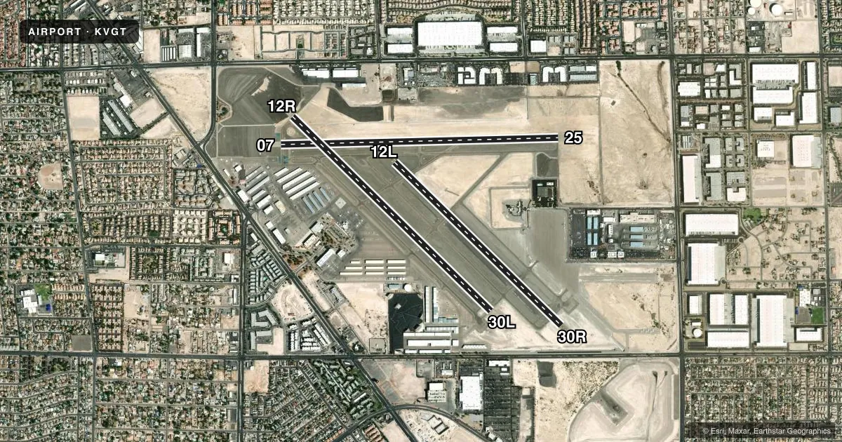
Runways & pattern
Full pagePattern entry · RWY 12R
LEFT TRAFFIC| Runway | Heading (°M) | Length | Surface | Traffic |
|---|---|---|---|---|
| 07/25 | 74° / 254° | 5,005 ft | ASPH | Standard L |
| 12R/30LFavored | 120° / 300° | 5,000 ft | ASPH | Standard L |
| 12L/30R | 120° / 300° | 4,199 ft | ASPH | Standard L |
Runway end performance
| End | TORA | TODA | ASDA | LDA | VGSI | Approach lights | Obstruction |
|---|---|---|---|---|---|---|---|
| 07 | 5,005' | 5,005' | 5,005' | 5,005' | PAPI 4-box left(3°) | — | 50', pole, 1434' from thr, 0' R of cntrln, slope 24 |
| 25 | 5,005' | 5,005' | 5,005' | 5,005' | PAPI 4-box left(3°) | — | — |
| 12R | 5,000' | 5,000' | 5,000' | 5,000' | PAPI 4-box left(3°) | — | 45', bldg, 1500' from thr, 0' R of cntrln, slope 28 |
| 30L | 5,000' | 5,000' | 5,000' | 5,000' | PAPI 4-box left(3°) | — | — |
| 12L | 4,199' | 4,199' | 4,199' | 4,199' | PAPI 4-box left(3.2°) | — | 45', bldg, 2019' from thr, 0' R of cntrln, slope 45 |
| 30R | 4,199' | 4,199' | 4,199' | 4,000' | PAPI 4-box left(3°) | — | — |
Declared distances in feet. TORA = takeoff run available, TODA = takeoff distance, ASDA = accelerate-stop, LDA = landing distance.
Airport sketch
Runways drawn to scale from FAA survey coordinates, rendered over satellite imagery. Not for navigation.
Approaches & charts
ILS · 1
Services on the field
Fuel grades, oxygen, maintenance, ramp storage and lighting — as declared to the FAA by the airport operator.
Fuel & services
- Fuel
- 100LLA
- Oxygen (bulk)
- High pressure
- Airframe repair
- Major
- Power plant repair
- Major
- Other services
- AMB,AVNCS,CARGO,CHTR,INSTR,RNTL,SALES
Ramp & ground
- Transient storage
- Tie-down
- Landing fee
- No fee published
- Customs
- Not available
- Lighting schedule
- SEE RMK
- Beacon schedule
- SS-SR
- Beacon
- White / Green (civil land)(WG)
- Wind indicator
- Lighted
- Segmented circle
- Yes
Fuel & FBOs
Cheapest 100LL and Jet A on the field and nearby. Always confirm with the FBO before taxi.
Airport notes
Surface conditions, obstructions, local procedures, lighting outages and other notes published with each FAA cycle.
General notes
- AIMING POINT MKD AT 1000 FT - ALL RWYS.
- RWY GUARD LGTS AT ALL INTXNS.
- FOR CD WHEN ATCT IS CLSD CTC LAS APCH ON 124.0 OR PH 725-200-4432.
- WHEN SPL EVENT PRKG PPR PROGRAM NOTAM IS ACTV, TSNT ACFT OPERS NOT PERM BASED NEED TO OBTAIN A PPR NR FM AN FBO FOR EA LDG. PPR APPVL & CONFIRMATION NRS CAN BE OBTAINED FM THE SEL FBO AT 702-261-7775. PPR CONFIRMATION NRS SHOULD BE ENTERED IN THE RMKS SECTION OF EACH FLT PLAN.
- RWY 12R CALM WIND RWY.
Lighting notes
- WHEN ATCT CLSD ACTVT REIL RWY 07 & 25, 12L & 30R, 12R & 30L; PAPI RWY 07 & 25, 12L & 30R, 12R & 30L; MIRL RWY 07/25, 12L/30R, 12R/30L; TWY LGTS - CTAF.
Other notes
- ARFF INDEX A, 139.315 (E)
- MANAGERMGR. ALSO 702-261-3802. 702.261.3804, NORTH LAS VEGAS AIRPORT 2730 AIRPORT DRIVE, SUITE 101 NORTH LAS VEGAS, NV 89032
VFR map & nearby airports
VFR sectional. Tap any ICAO chip to open that airport.
Key facts · KVGT
Answer card- ICAO
- KVGT
- Name
- NORTH LAS VEGAS
- Location
- LAS VEGAS, NEVADA
- Elevation
- 2,205 ft MSL
- Traffic pattern altitude
- 3,005 ft MSL (800 AGL)
- Control tower
- Towered · 0600-2000 OCT-MAR; 0600-2100 APR-SEP
- Total runways
- 3
- Longest runway
- 07/25 · 5,005 ft
- Published ILS approaches
- 1
- Published frequencies
- 13
- Magnetic variation
- 14°
- Current flight rules
- VFR
- Current wind
- 180° at 7 kt
- Favored runway now
- RWY 12R
North Las Vegas Airport (KVGT) sits in North Las Vegas, Nevada, in the Las Vegas area. Field elevation is 2,205 ft MSL. The airport has 3 asphalt runways. The longest is 5,005 ft on 07/25. The tower is open 0600-2000 OCT-MAR and 0600-2100 APR-SEP. There is one ILS approach. It serves runway 12L. Pattern altitude is 800 ft AGL, which is 3,005 ft MSL.
North Las Vegas Airport has one on-field FBO, North Las Vegas Airport. It carries 100LL, Jet A and Jet A Prist. The airport sits in a busy metro area, so expect close traffic and stay sharp on tower instructions. Runway 12R is the calm wind runway. The published remarks also note an aiming point marking at 1,000 ft on all runways. When the tower is closed, lighting and clearance delivery procedures change, so verify the current Chart Supplement before a night arrival or any after-hours operation. If the special event parking prior permission required program is active, transient aircraft may need prior permission approval before landing. Check that status before you go.