METAR & TAF KVBT
Current METAR
Observed 20:56Z
KVBT 272056Z AUTO 25010G14KT 10SM CLR 36/21 A2990 RMK AO2 SLP111 T03560211 56021
- Wind
- 250° @ 10G14 kt
- Visibility
- 10 SM
- Temp / Dew
- 36°C / 21°C
- Altimeter
- 29.90 inHg
- Clouds
- CLR
- Density alt
- 4,154 ft
- Ceiling
- Unlimited
- Rules
- VFR
Airport info & contacts
Manager on record, flight service, ARTCC, attendance schedule and pattern altitude — published by the FAA and refreshed every 28 days.
Location
- From city
- 2 NM S
- VFR sectional
- KANSAS CITY
- ARTCC
- ZME · MEMPHIS
- NOTAM facility
- VBT (NOTAM-D)
Airport manager
- Name
- MARK SLAUGHTER
- Phone
- 817-946-4991
- Address
- 1000 SW 14TH STREET, BENTONVILLE AR 72712
Flight service · Hours
- FSS JBR
- JONESBORO1-800-WX-BRIEF
- Attendance
- OCT-MAR · 0730-1600
- APR-SEP · 0730-1600
Frequencies
Tap any row to copy the frequency to your clipboard.
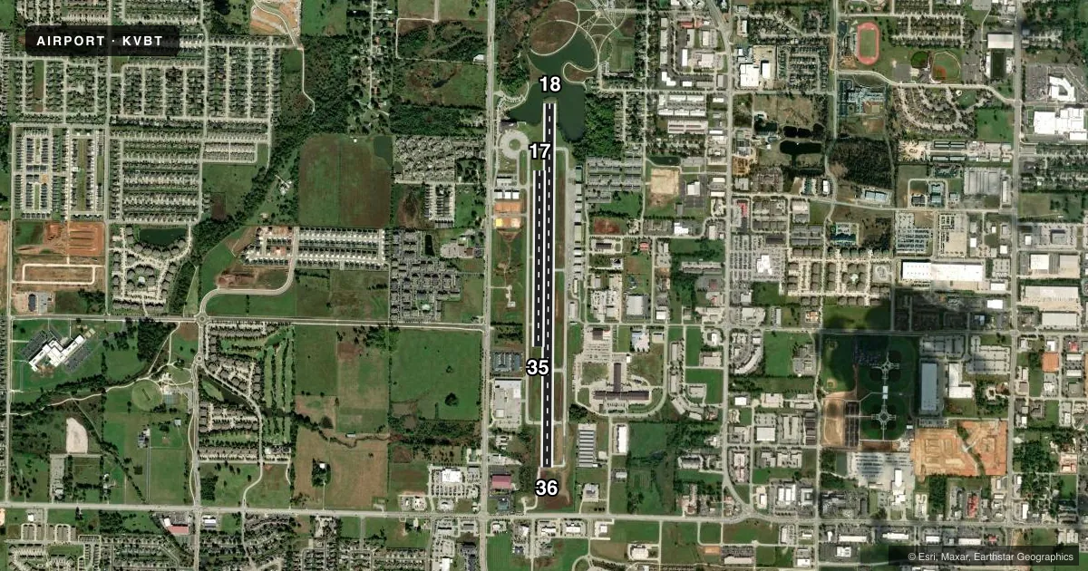
Runways & pattern
Full pagePattern entry · RWY 18
LEFT TRAFFIC| Runway | Heading (°M) | Length | Surface | Traffic |
|---|---|---|---|---|
| 18/36Favored | 179° / 359° | 5,053 ft | ASPH | Standard L |
| 17/35 | 179° / 359° | 2,448 ft | TURF | Standard L |
Runway end performance
| End | TORA | TODA | ASDA | LDA | VGSI | Approach lights | Obstruction |
|---|---|---|---|---|---|---|---|
| 18 | 4,453' | 4,453' | 4,453' | 4,196' | PAPI 2-box left(3°) | — | 19', brush, 510' from thr, 285' R of cntrln, slope 16 |
| 36 | 4,453' | 4,453' | 4,196' | 4,196' | PAPI 2-box right(3°) | — | 12', pole, 615' from thr, 170' R of cntrln, slope 34 |
| 17 | 2,448' | 2,448' | — | — | — | — | — |
| 35 | 2,448' | 2,448' | — | — | — | — | — |
Declared distances in feet. TORA = takeoff run available, TODA = takeoff distance, ASDA = accelerate-stop, LDA = landing distance.
Airport sketch
Runways drawn to scale from FAA survey coordinates, rendered over satellite imagery. Not for navigation.
Approaches & charts
Services on the field
Fuel grades, oxygen, maintenance, ramp storage and lighting — as declared to the FAA by the airport operator.
Fuel & services
- Fuel
- 100LLA
- Oxygen (bottled)
- High pressure
- Oxygen (bulk)
- Not available
- Airframe repair
- Major
- Power plant repair
- Major
- Other services
- CHTR,INSTR,RNTL,SALES
Ramp & ground
- Transient storage
- Tie-down
- Hangar
- Landing fee
- No fee published
- Customs
- Not available
- Lighting schedule
- SEE RMK
- Beacon schedule
- SS-SR
- Beacon
- White / Green (civil land)(WG)
- Wind indicator
- Lighted
- Segmented circle
- No
Fuel & FBOs
Cheapest 100LL and Jet A on the field and nearby. Always confirm with the FBO before taxi.
Airport notes
Surface conditions, obstructions, local procedures, lighting outages and other notes published with each FAA cycle.
General notes
- BEGINNING 60 FT BYD NORTH END OF RY 18 PAVEMENT, GND HAS APROXLY 12 FT DROP OVER 60 FT LENGTH TO POND.
- FOR CD CTC RAZORBACK APCH 479-649-2416, WHEN APCH CLSD CTC MEMPHIS ARTCC AT 901-368-8453/8449.
- MIGRATORY BIRDS ON & INVOF ARPT
- RWY 17/35 VFR DALGT OPNS ONLY.
- SIMUL USE OF RWYS 17/35 AND 18/36 NA.
Lighting notes
- ACTVT PAPI RWY 18 & 36, MIRL RWY 18/36 - CTAF.
Runway surface & condition
- 18/36PCR VALUE: 214/F/D/X/T
Approach & departure obstructions
- 18APCH RATIO 38:1 TO DTHR.
VFR map & nearby airports
VFR sectional. Tap any ICAO chip to open that airport.
Key facts · KVBT
Answer card- ICAO
- KVBT
- Name
- BENTONVILLE MUNI/LOUISE M THADEN FLD
- Location
- BENTONVILLE, ARKANSAS
- Elevation
- 1,297.9 ft MSL
- Traffic pattern altitude
- 2,297.9 ft MSL (1,000 AGL)
- Control tower
- Non-towered (use CTAF)
- Total runways
- 2
- Longest runway
- 18/36 · 5,053 ft
- Published ILS approaches
- 0
- Published frequencies
- 6
- Magnetic variation
- 1°
- Current flight rules
- VFR
- Current wind
- 250° at 10 kt
- Favored runway now
- RWY 18
Bentonville Muni/Louise M Thaden Fld (KVBT) sits in Bentonville, Arkansas at 1,297.9 ft MSL. The field has two runways. The longest is 18/36 at 5,053 ft. Runway 17/35 is turf at 2,448 ft. There is no control tower. Published traffic pattern altitude is not given, so use the standard 1,000 ft AGL for light piston operations unless the current Chart Supplement says otherwise.
No ILS approaches are published here. That matters if you are planning a low-weather arrival. Check the current Chart Supplement for the latest approach setup before you launch. Legends Air Center is on the field. It carries 100LL and Jet A Prist. For clearance delivery, Razorback Approach is listed in the remarks. If approach is closed, contact Memphis ARTCC directly.
A few operational notes matter here. Migratory birds are reported on and near the airport. Runway 17/35 is for VFR daylight use only. Simultaneous use of runways 17/35 and 18/36 is not authorized. For runway 18/36, the PAPI and medium intensity runway lights are activated on CTAF. The north end of runway 18 has a drop to a pond just beyond the pavement, so pay attention on rollout and on any short-field planning.