METAR & TAF KTBN
Current METAR
Observed 20:55Z
KTBN 272055Z 23006G16KT 10SM FEW050 FEW250 36/23 A2984 RMK AO2A SLP092 T03600225 55016 $
- Wind
- 230° @ 6G16 kt
- Visibility
- 10 SM
- Temp / Dew
- 36°C / 23°C
- Altimeter
- 29.84 inHg
- Clouds
- FEW
- Density alt
- 4,057 ft
- Ceiling
- Unlimited
- Rules
- VFR
Airport info & contacts
Manager on record, flight service, ARTCC, attendance schedule and pattern altitude — published by the FAA and refreshed every 28 days.
Location
- From city
- 0 NM SW
- VFR sectional
- KANSAS CITY
- ARTCC
- ZKC · KANSAS CITY
- NOTAM facility
- TBN (NOTAM-D)
Airport manager
- Name
- MIKE GUY
- Phone
- 573-596-0165
- Address
- FORNEY ARMY AIRFIELD, FT LEONARD WOOD MO 65473
Flight service · Hours
- FSS COU
- COLUMBIA1-800-WX-BRIEF
- Attendance
- MON-FRI · 0800-1700
Frequencies
Tap any row to copy the frequency to your clipboard.
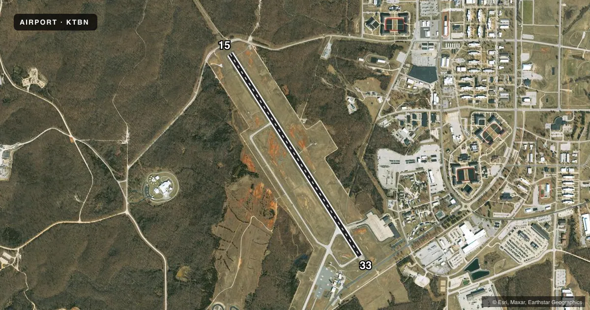
Runways & pattern
Full pagePattern entry · RWY 15
LEFT TRAFFICRunway end performance
| End | TORA | TODA | ASDA | LDA | VGSI | Approach lights | Obstruction |
|---|---|---|---|---|---|---|---|
| 15 | — | — | — | — | PAPI 4-box left(3°) | MALSR | 9', pole, 210' from thr, 450' R of cntrln, slope 1 |
| 33 | — | — | — | — | PAPI 4-box right(3°) | MALS | 17', road, 450' from thr, 0' R of cntrln, slope 14 |
Declared distances in feet. TORA = takeoff run available, TODA = takeoff distance, ASDA = accelerate-stop, LDA = landing distance.
Airport sketch
Runways drawn to scale from FAA survey coordinates, rendered over satellite imagery. Not for navigation.
Approaches & charts
ILS · 1
Services on the field
Fuel grades, oxygen, maintenance, ramp storage and lighting — as declared to the FAA by the airport operator.
Fuel & services
- Fuel
- 100LLA
- Oxygen (bottled)
- Not available
- Oxygen (bulk)
- Not available
- Airframe repair
- Not available
- Power plant repair
- Not available
Ramp & ground
- Transient storage
- Tie-down
- Hangar
- Landing fee
- No fee published
- Customs
- Not available
- Lighting schedule
- SEE RMK
- Beacon schedule
- SS-SR
- Beacon
- Split White / Green (military)(SWG)
- Wind indicator
- Lighted
- Segmented circle
- No
Fuel & FBOs
Cheapest 100LL and Jet A on the field and nearby. Always confirm with the FBO before taxi.
Airport notes
Surface conditions, obstructions, local procedures, lighting outages and other notes published with each FAA cycle.
General notes
- RSTD: PPR FOR ALL TRAN MIL ACFT DSN 581-0165/4819; C573-596-0165/4819.
- SFC VSBY LIMITED BY TREE LINE FM E TO S TO W.
- WX SVC AVBL MON-FRI EXC HOL 1300-0400Z++. AN/FMQ-19 AUTOMATED OBSERVING SYS IN USE; AUGMENTED BY HUMAN OBSN WHEN NEC DUR AFLD HRS. OT REMOTE BRIEFING SVC AVBL 26 OWS BARKSDALE AFB DSN 781-4775, C318-456-4775, C866-223-2398 (TOLL FREE).
- MILITARY SERVICE: NO MIL FUEL AVBL. CIV: NC A AVBL 1400-2300Z++ OT C573-329-4216. 100LL AVBL H24 WITH CREDIT CARD.
- MILITARY: SVC: SOUTH END OF RWY SAFETY ZONE UNPROTECTED WHEN TWR CLSD.
- WHEN ATCT CLSD, FOR CD CTC KANSAS CITY ARTCC AT 913-254-8508.
- RSTD: CIV FBO RAMP CLSD TO MIL ACFT.
- ARR AND DEP LRG ACFT MUST USE THE ALPHA TWY INT AT THE SE EOR 15-33 TO ACES AND EXIT THE RWY. ARR AND DEP LRG ACFT ARE REQUIRED TO BACK-TAXI ON THE RWY.
Lighting notes
- WHEN TWR CLSD ACTVT MALS RWY 33; MALSR RWY 15; REIL RWY 15 & 33; PAPI RWY 15 & 33; HIRL RWY 15/33 - CTAF.
Runway surface & condition
- 15/33PCR VALUE: 300/F/C/X/U
Approach & departure obstructions
- 33+15' GND AT 200'; 200-500' R CTRLN; OBST LIGHTED FENCE.
- 1550:1 TO DSPLCD THR.
- 3350:1 TO DSPLCD THR.
Other notes
- 1EXCLUDING HOLS.
- MANAGERAIRPORT MANAGER (CIVIL) MIKE GUY 573-329-4216
VFR map & nearby airports
VFR sectional. Tap any ICAO chip to open that airport.
Key facts · KTBN
Answer card- ICAO
- KTBN
- Name
- WAYNESVILLE-ST ROBERT RGNL FORNEY FLD
- Location
- FORT LEONARD WOOD, MISSOURI
- Elevation
- 1,159.5 ft MSL
- Traffic pattern altitude
- 2,159.5 ft MSL (1,000 AGL)
- Control tower
- Towered · 1300-0400Z++ MON-FRI EXC HOL
- Total runways
- 1
- Longest runway
- 15/33 · 6,037 ft
- Published ILS approaches
- 1
- Published frequencies
- 11
- Magnetic variation
- 0°
- Current flight rules
- VFR
- Current wind
- 230° at 6 kt
- Favored runway now
- RWY 15
Waynesville-St Robert Rgnl Forney Fld sits at Fort Leonard Wood in Missouri. The field elevation is 1,159.5 ft MSL. KTBN has one runway, 15/33, at 6,037 ft on asphalt. The airport is towered. Tower hours are 1300-0400Z Monday through Friday except holidays. One ILS approach is published for runway 15. Pattern altitude is not published in the facts, so verify the current Chart Supplement before you fly. For light piston traffic, use the standard 1,000 ft AGL pattern only if the current published data supports that choice.
St. Robert Cities Aviation is on the field. It carries 100LL and Jet A Prist. 100LL is available 24 hours with credit card. Civilian fuel service is available 1400-2300Z and later. Military fuel is not available. The published remarks also note that large aircraft must use the Alpha taxiway intersection at the southeast end of runway 15-33 to ACES and then back-taxi. That is worth planning for if you are bringing in a larger airframe.
A few operational details matter here. Surface visibility is limited by the tree line from east to south to west. The south end of the runway safety zone is unprotected when the tower is closed. When the tower is closed, use CTAF to activate the runway lighting. Check the current Chart Supplement for any published noise or curfew restrictions before flying into the field.