METAR & TAF KSPK
Current METAR
Observed 13:35Z
KSPK 271335Z AUTO 13009KT 10SM SCT120 28/10 A3007 RMK AO2
- Wind
- 130° @ 9 kt
- Visibility
- 10 SM
- Temp / Dew
- 28°C / 10°C
- Altimeter
- 30.07 inHg
- Clouds
- SCT
- Density alt
- 6,991 ft
- Ceiling
- Unlimited
- Rules
- VFR
Airport info & contacts
Manager on record, flight service, ARTCC, attendance schedule and pattern altitude — published by the FAA and refreshed every 28 days.
Location
- From city
- 2 NM N
- VFR sectional
- SALT LAKE CITY
- ARTCC
- ZLC · SALT LAKE CITY
- NOTAM facility
- CDC (NOTAM-D)
Airport manager
- Name
- CHRISTIAN DAVIS
- Phone
- 801-804-4593
- Address
- 2050 NORTH 300 WEST, SPANISH FORK UT 84660
Flight service · Hours
- FSS CDC
- CEDAR CITY1-800-WX-BRIEF
- Attendance
- MON-SAT · 0900-1700
Frequencies
Tap any row to copy the frequency to your clipboard.
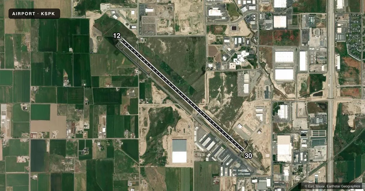
Runways & pattern
Full pagePattern entry · RWY 12
LEFT TRAFFICRunway end performance
| End | TORA | TODA | ASDA | LDA | VGSI | Approach lights | Obstruction |
|---|---|---|---|---|---|---|---|
| 12 | — | — | — | — | PAPI 4-box left(3°) | — | — |
| 30 | — | — | — | — | PAPI 4-box left(3°) | — | 16', road, 350' from thr, 0' R of cntrln, slope 20 |
Declared distances in feet. TORA = takeoff run available, TODA = takeoff distance, ASDA = accelerate-stop, LDA = landing distance.
Airport sketch
Runways drawn to scale from FAA survey coordinates, rendered over satellite imagery. Not for navigation.
Approaches & charts
Services on the field
Fuel grades, oxygen, maintenance, ramp storage and lighting — as declared to the FAA by the airport operator.
Fuel & services
- Fuel
- 100LLA
- Oxygen (bottled)
- Not available
- Oxygen (bulk)
- Not available
- Airframe repair
- Major
- Power plant repair
- Major
- Other services
- AVNCS,INSTR,RNTL
Ramp & ground
- Transient storage
- Tie-down
- Hangar
- Lighting schedule
- SEE RMK
- Beacon schedule
- SS-SR
- Beacon
- White / Green (civil land)(WG)
- Wind indicator
- Lighted
- Segmented circle
- Yes
Fuel & FBOs
Cheapest 100LL and Jet A on the field and nearby. Always confirm with the FBO before taxi.
Airport notes
Surface conditions, obstructions, local procedures, lighting outages and other notes published with each FAA cycle.
General notes
- FOR CD CTC SALT LAKE CITY APCH AT 801-325-9670.
- COLD TEMPERATURE AIRPORT. ALTITUDE CORRECTION REQUIRED AT OR BELOW -17C.
- RWY 12 APCH, 60 FT MKD/LGTD PLINE, 1475 FT DSTC, 0 FT BOTH, APCH SLOPE 21:1.
- LNDG FEES IN EFCT FOR ALL ACFT.
Lighting notes
- ACTVT REIL RWY 12 & 30; PAPI RWY 12 & 30; MIRL RWY 12/30 - CTAF.
Fuel notes
- 100LLSELF SVC 100LL AVBL 24 HRS.
- AFOR JET A FUEL CALL 801-798-9888.
Other notes
- TPA FOR FIXED WING ACFT IS 1000 FT AGL; TPA FOR ROTARY WING ACFT IS 500 FT AGL.
- 1AFT HRS FUEL ATNDT 801-798-9888.
VFR map & nearby airports
VFR sectional. Tap any ICAO chip to open that airport.
Key facts · KSPK
Answer card- ICAO
- KSPK
- Name
- SPANISH FORK MUNI/WOODHOUSE FLD
- Location
- SPANISH FORK, UTAH
- Elevation
- 4,529.5 ft MSL
- Traffic pattern altitude
- 5,529.5 ft MSL (1,000 AGL)
- Control tower
- Non-towered (use CTAF)
- Total runways
- 1
- Longest runway
- 12/30 · 6,500 ft
- Published ILS approaches
- 0
- Published frequencies
- 3
- Magnetic variation
- 11°
- Current flight rules
- VFR
- Current wind
- 130° at 9 kt
- Favored runway now
- RWY 12
Spanish Fork Muni/Woodhouse Fld is in Spanish Fork, Utah. Field elevation is 4,529.5 ft MSL. The airport has one runway. Runway 12/30 is 6,500 ft of asphalt, so you have a single long strip to work with. There is no control tower. CTAF is 122.9. Salt Lake City Approach handles the approach and departure side on 118.85 and 233.7. No ILS approaches are published here.
For fixed wing traffic, the published pattern altitude is 1,000 ft AGL. That puts the pattern at 5,529.5 ft MSL. This is a high-elevation field, so density altitude planning matters even on a cool day. The airport is also a cold temperature airport. Altitude correction is required at or below minus 17 degrees Celsius.
Utah Aviation Services is on the field. It carries 100LL and Jet A with Prist. Self-serve 100LL is available 24 hours. After-hours fuel service is handled through the same phone number. Published remarks also note landing fees apply to all aircraft. Runway 12 has a marked and lighted power line on short final. The runway also has REILs, PAPI and medium intensity lights that are controlled by CTAF. If you are new to the field, brief the elevation, the non-towered pattern and the runway 12 obstacle picture before you go.