METAR & TAF KSNA
Current METAR
Observed 09:53Z
KSNA 270953Z AUTO 18003KT 8SM OVC012 22/20 A2991 RMK AO2 SLP127 T02170200
- Wind
- 180° @ 3 kt
- Visibility
- 8 SM
- Temp / Dew
- 22°C / 20°C
- Altimeter
- 29.91 inHg
- Clouds
- OVC
- Density alt
- 922 ft
- Ceiling
- 1,200 ft AGL
- Rules
- MVFR
Airport info & contacts
Manager on record, flight service, ARTCC, attendance schedule and pattern altitude — published by the FAA and refreshed every 28 days.
Location
- From city
- 4 NM S
- VFR sectional
- LOS ANGELES
- ARTCC
- ZLA · LOS ANGELES
- NOTAM facility
- SNA (NOTAM-D)
Airport manager
- Name
- CHARLENE V. REYNOLDS
- Phone
- 949-252-5171
- Address
- 3160 AIRWAY AVE, COSTA MESA CA 92626
Flight service · Hours
- FSS RAL
- RIVERSIDE1-800-WX-BRIEF
- Attendance
- ALL
Frequencies
Tap any row to copy the frequency to your clipboard.
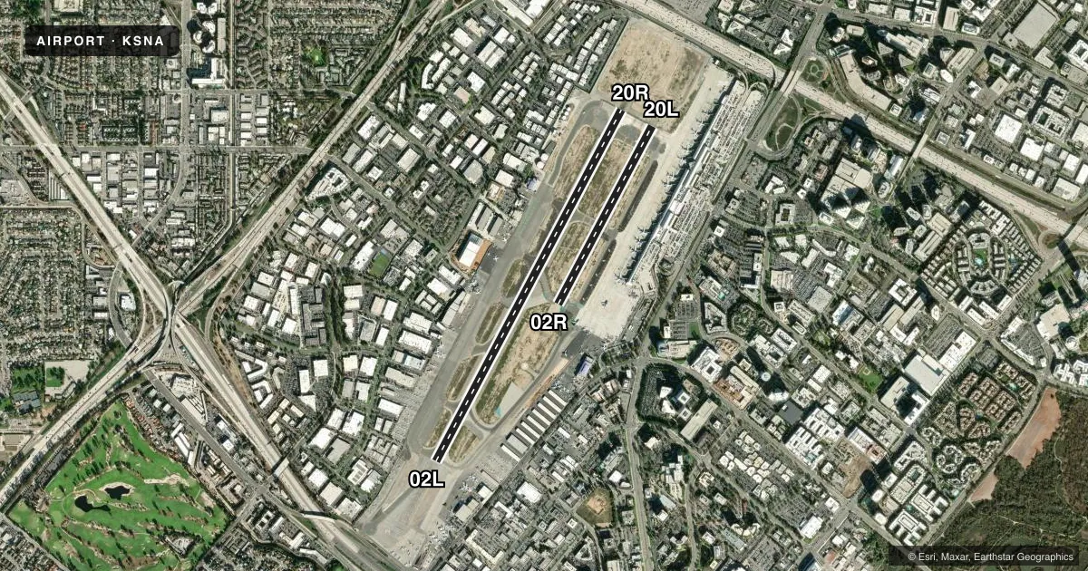
Runways & pattern
Full pagePattern entry · RWY 20R
RIGHT TRAFFIC| Runway | Heading (°M) | Length | Surface | Traffic |
|---|---|---|---|---|
| 02L/20RFavored | 16° / 196° | 5,700 ft | ASPH | 20R R |
| 02R/20L | 16° / 196° | 2,886 ft | ASPH | 02R R |
Runway end performance
| End | TORA | TODA | ASDA | LDA | VGSI | Approach lights | Obstruction |
|---|---|---|---|---|---|---|---|
| 02L | 5,700' | 5,700' | 5,700' | 5,700' | PAPI 4-box left(3°) | — | — |
| 20R | 5,700' | 5,700' | 5,700' | 5,700' | PAPI 4-box left(3°) | MALSR | — |
| 20L | — | — | — | — | PAPI 4-box left(3°) | — | 15', bldg, 500' from thr, 115' R of cntrln, slope 20 |
Declared distances in feet. TORA = takeoff run available, TODA = takeoff distance, ASDA = accelerate-stop, LDA = landing distance.
Airport sketch
Runways drawn to scale from FAA survey coordinates, rendered over satellite imagery. Not for navigation.
Approaches & charts
ILS · 2
Services on the field
Fuel grades, oxygen, maintenance, ramp storage and lighting — as declared to the FAA by the airport operator.
Fuel & services
- Fuel
- 100LLA
- Oxygen (bottled)
- HIGH/LOW
- Airframe repair
- Major
- Power plant repair
- Major
- Other services
- AFRT,AMB,AVNCS,CHTR,INSTR,RNTL,SALES,SURV
Ramp & ground
- Transient storage
- Tie-down
- Landing fee
- No fee published
- Customs
- Not available
- Lighting schedule
- SEE RMK
- Beacon schedule
- SS-SR
- Beacon
- White / Green (civil land)(WG)
- Wind indicator
- Lighted
- Segmented circle
- Yes
Fuel & FBOs
Cheapest 100LL and Jet A on the field and nearby. Always confirm with the FBO before taxi.
Airport notes
Surface conditions, obstructions, local procedures, lighting outages and other notes published with each FAA cycle.
General notes
- WHEN ATCT CLSD NO LCL TRNG OR TOUCH & GO OPNS.
- BE ALERT TO BIRDS ON AND IN VICINITY OF ARPT.
- TWY C GWT LMTD 60000 LBS.
- MAINTAIN AT OR ABOVE 300 FT AGL UNTIL ESTABLISHED ON FINAL .
- FBO GENERAL AVIATION APRONS LIMITED TO MAX GWT OF 100,000 LBS (DUAL GEAR) AND WITH WINGSPANS LESS THAN 100 FT. GENERAL AVIATION AIRCRAFT PROHIBITED FROM USING ANY PORTION OF THE AIR CARRIER COMMERCIAL RAMP.
- NOISE ABATEMENT PROCEDURES IN EFFECT CTC ARPT NOISE OFFICE (949) 252-5185.
- RWY 02L/20R TPA 1000 FT AGL SMALL ACFT; 1500 FT AGL TURBINE ACFT OVER 12500 LBS; RWY 02R/20L TPA 800 FT AGL SMALL SGL ENG ACFT; 1000 FT AGL TWIN ENG ACFT.
- FOR CD WHEN ATCT CLSD CTC SOCAL APCH AT 800-448-3724.
- ACFT LDG RWY 20L, USE CTN FOR JET BLAST FROM ACFT HLDG BTN RWY 20L AND RWY 20R AT TWY L AND CTN WAKE TURB FROM JET ACFT LDG RWY 20R.
- VFR ACFT: TO AVOID OVERFLIGHT OF RWY 20R, RWY 20L ARRS FLY FINAL AT 15 DEG ANGLE TO RWY; RWY 20L DEPS TURN 15 DEGS LEFT AT DEP END OF RWY. TO AVOID OVERFLIGHT OF RWY 02L, RWY 02R DEPS TURN 15 DEGS RIGHT AT DEP END OF RWY.
- CTC GND CTL PRIOR TO PUSHBACK ON TWY A AND TWY B.
Lighting notes
- WHEN ATCT CLSD ACTVT MALSR RY 20R & PAPI RYS 02L & 20R - CTAF.
Runway surface & condition
- 02L/20RPCR VALUE: 602/F/A/X/T
- 02R/20LRWY 02R/20L NOT AVBL FOR PART 121/PART 380 OPS WITH SKED PAX CARRYING OPS MORE THAN 9 PAX SEATS AND NON-SKED PAX CARRYING OPS MORE THAN 30 PAX SEATS. RWY 02R/20L CLSD WHEN ATCT CLSD.
- 20XRY 20X CREATED TO SUPPORT OJW LDA ASSOCIATED WITH SNA ILS RY 20R.
Other notes
- OVERNIGHT TIE-DOWN FEE.
- MANAGERRON MCCLELLAN, MGR, AIRSIDE OPNS 949-252-5247.
VFR map & nearby airports
VFR sectional. Tap any ICAO chip to open that airport.
Key facts · KSNA
Answer card- ICAO
- KSNA
- Name
- JOHN WAYNE/ORANGE COUNTY
- Location
- SANTA ANA, CALIFORNIA
- Elevation
- 55.9 ft MSL
- Traffic pattern altitude
- 1,055.9 ft MSL (1,000 AGL)
- Control tower
- Towered · 0615-2300
- Total runways
- 2
- Longest runway
- 02L/20R · 5,700 ft
- Published ILS approaches
- 2
- Published frequencies
- 29
- Magnetic variation
- 12°
- Current flight rules
- MVFR
- Current wind
- 180° at 3 kt
- Favored runway now
- RWY 20R
KSNA is in Santa Ana, California. Field elevation is 55.9 ft MSL. The airport has 2 asphalt runways. The longest is runway 02L/20R at 5,700 ft. The tower is open daily from 0615 to 2300. When the tower is closed, runway 02R/20L is not available. That matters if you are planning a late arrival or an early departure.
Two ILS approaches are published here. They serve runway ends 20R and 20X. SOCAL handles the Class C airspace and approach control. Pattern altitude is published by runway and aircraft type. Runway 02L/20R uses 1,000 ft AGL for small aircraft. Turbine aircraft over 12,500 lb use 1,500 ft AGL. Runway 02R/20L uses 800 ft AGL for small single-engine aircraft. Twins use 1,000 ft AGL.
On field FBOs are Clay Lacy Aviation, ACI Jet - Orange County South and ACI Jet - Orange County North. They carry 100LL, Jet A and Jet A Prist. Noise abatement is active. The airport also has specific runway departure and arrival angles to reduce overflight of the parallel runway. If you are new to KSNA, brief those procedures before taxi. Keep the airport noise office number handy if you need the current local rules. The field also has ramp and weight limits that matter for larger aircraft.