METAR & TAF KSFO
Current METAR
Observed 07:56Z
KSFO 280756Z 28015G22KT 10SM FEW006 BKN012 16/13 A2997 RMK AO2 SLP149 T01560133 402110144
- Wind
- 280° @ 15G22 kt
- Visibility
- 10 SM
- Temp / Dew
- 16°C / 13°C
- Altimeter
- 29.97 inHg
- Clouds
- BKN
- Density alt
- 74 ft
- Ceiling
- 1,200 ft AGL
- Rules
- MVFR
Airport info & contacts
Manager on record, flight service, ARTCC, attendance schedule and pattern altitude — published by the FAA and refreshed every 28 days.
Location
- From city
- 8 NM SE
- VFR sectional
- SAN FRANCISCO
- ARTCC
- ZOA · OAKLAND
- NOTAM facility
- SFO (NOTAM-D)
Airport manager
- Name
- MIKE NAKORNKHET
- Phone
- 650-821-5000
- Address
- PO BOX 8097, SAN FRANCISCO CA 94128
Flight service · Hours
- FSS OAK
- OAKLAND1-800-WX-BRIEF
- Attendance
- ALL
Frequencies
Tap any row to copy the frequency to your clipboard.
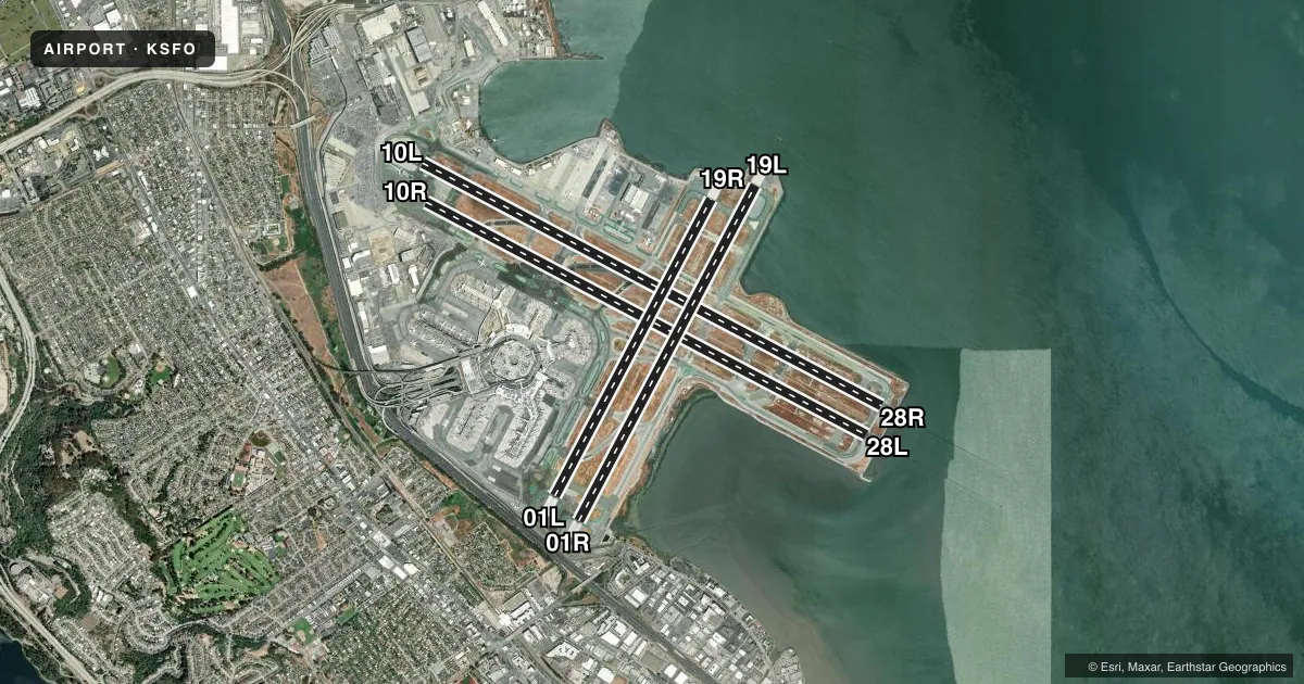
Runways & pattern
Full pagePattern entry · RWY 28R
RIGHT TRAFFIC| Runway | Heading (°M) | Length | Surface | Traffic |
|---|---|---|---|---|
| 10L/28RFavored | 104° / 284° | 11,870 ft | ASPH | 28R R |
| 10R/28L | 104° / 284° | 11,381 ft | ASPH | 10R R |
| 01R/19L | 14° / 194° | 8,650 ft | ASPH | Standard L |
| 01L/19R | 14° / 194° | 7,650 ft | ASPH | Standard L |
Runway end performance
| End | TORA | TODA | ASDA | LDA | VGSI | Approach lights | Obstruction |
|---|---|---|---|---|---|---|---|
| 10L | 11,870' | 11,870' | 11,193' | 11,193' | PAPI 4-box left(3°) | — | 88', tower, 3280' from thr, 1300' R of cntrln, slope 35 |
| 28R | 11,870' | 11,870' | 11,870' | 11,236' | PAPI 4-box left(3°) | ALSF2 | — |
| 10R | 11,381' | 11,381' | 10,704' | 10,704' | PAPI 4-box left(3°) | — | 87', tower, 3875' from thr, 950' R of cntrln, slope 42 |
| 28L | 11,381' | 11,381' | 10,981' | 10,275' | PAPI 4-box left(2.85°) | MALSR | — |
| 01R | 8,650' | 8,650' | 8,650' | 8,090' | — | — | 177', tree, 4000' from thr, 200' R of cntrln, slope 21 |
| 19L | 8,650' | 8,650' | 8,650' | 8,650' | PAPI 4-box left(3°) | MALSF | — |
| 01L | 7,650' | 7,650' | 7,650' | 7,010' | — | — | — |
| 19R | 7,650' | 7,650' | 7,650' | 7,650' | PAPI 4-box left(3.15°) | — | — |
Declared distances in feet. TORA = takeoff run available, TODA = takeoff distance, ASDA = accelerate-stop, LDA = landing distance.
Airport sketch
Runways drawn to scale from FAA survey coordinates, rendered over satellite imagery. Not for navigation.
Approaches & charts
ILS · 3
Services on the field
Fuel grades, oxygen, maintenance, ramp storage and lighting — as declared to the FAA by the airport operator.
Fuel & services
- Fuel
- 100LLAA++
- Oxygen (bottled)
- HIGH/LOW
- Oxygen (bulk)
- Not available
- Airframe repair
- Not available
- Power plant repair
- Not available
- Other services
- AFRT,AVNCS,CARGO,CHTR
Ramp & ground
- Transient storage
- Hangar
- Landing fee
- Yes
- Customs
- Not available
- Beacon schedule
- SS-SR
- Beacon
- White / Green (civil land)(WG)
- Wind indicator
- Lighted
- Segmented circle
- No
Fuel & FBOs
Cheapest 100LL and Jet A on the field and nearby. Always confirm with the FBO before taxi.
Airport notes
Surface conditions, obstructions, local procedures, lighting outages and other notes published with each FAA cycle.
General notes
- FLOCKS OF BIRDS FEEDING ALONG SHORELINE ADJ TO ARPT; ON OCCASIONS FLY ACROSS VARIOUS PARTS OF THE ARPT.
- HIGH SPEED TWY (T) GRVD FULL WIDTH BTN RWY 28R AND 28L.
- NOISE SENSITIVE ARPT; FOR NOISE ABATEMENT PROCEDURES CTC ARPT NOISE OFFICE MON-FRI 0800-1700 BY CALLING 650-821-5100.
- SEVERAL RY HOLD POSITION SIGNS ARE ON THE RIGHT RATHER THAN THE LEFT SIDE OF THE TWYS.
- RY 10 PREFERRED RY BTWN 0100-0600 WEATHER AND FLIGHT CONDITIONS PERMITTING.
- AIRLINE PILOTS SHALL STRICTLY FOLLOW THE PAINTED NOSE GEAR LINES AND NO OVERSTEERING ADJUSTMENT IS PERMITTED.
- PAEW APCH END RYS 28L, 28R, 19L INDEFLY.
- ALL OUBD TWY ZULU 2 HVY ACFT WITH A WINGSPAN OF 171 FT OR GTR UNDER PWR PROHIBITED FROM ENTERING WB TWY ZULU.
- SIMULTANEOUS OPERATIONS IN EFFECT ALL RYS.
- RWY 1L CLSD TO DEPARTING TRIJET ACFT WITH WINGSPAN GREATER THAN 155 FT.
- RWY STATUS LGTS IN OPN.
- TWY S BTN TWY Z AND TWY S2 CLSD TO ACFT WITH WINGSPAN OVER 215 FT.
- DUE TO OBSTD VISION, SFO TWR IS ABLE TO PRVD ONLY LTD ARPT TFC CTL SVC ON TWY A BTN GATES F20 AND F21.
Runway surface & condition
- 01L/19RPCR VALUE: 956/F/C/W/T
- 01R/19LPCR VALUE: 986/F/C/W/T
- 10L/28RPCR VALUE: 918/F/C/W/T
- 10R/28LPCR VALUE: 866/F/B/W/T
Approach & departure obstructions
- 01RAPCH BLOCKED BY A BLAST FENCE AND LOC ANT.
- 01RAPCH RATIO 28:1 TO DISPLACED THRESHOLD.
Arresting gear
- 01L_EMASENGINEERED MATERIAL ARRESTING SYSTEM (EMAS) 413 FT IN LENGTH BY 227 FT IN WIDTH LCTD AT THE DER 1L.
- 01R_EMASENGINEERED MATERIALS ARRESTING SYSTEM (EMAS) 409 FT IN LENGTH BY 227 FT IN WIDTH LCTD AT THE DER 1R.
- 19L_EMASENGINEERED MATERIALS ARRESTING SYSTEM (EMAS) 373 FT IN LENGTH BY 227 FT IN WIDTH LCTD AT THE DER 19L.
- 19R_EMASENGINEERED MATERIALS ARRESTING SYSTEM (EMAS) 437 FT IN LENGTH BY 227 FT IN WIDTH LCTD AT THE DER 19R.
Other notes
- MANAGERJACK BELL: AIRSIDE OPNS DIR PHONE 650-821-3348.
- OWNERGLENN BROTMAN: AIRFIELD OPERATIONS PHONE 650-821-3349 AND FAX 650-821-4670. SHANNON WILSON: AIRFIELD OPERATIONS PHONE 650-821-3366.
VFR map & nearby airports
VFR sectional. Tap any ICAO chip to open that airport.
Key facts · KSFO
Answer card- ICAO
- KSFO
- Name
- SAN FRANCISCO INTL
- Location
- SAN FRANCISCO, CALIFORNIA
- Elevation
- 13.1 ft MSL
- Traffic pattern altitude
- 1,013.1 ft MSL (1,000 AGL)
- Control tower
- Towered · 24
- Total runways
- 4
- Longest runway
- 10L/28R · 11,870 ft
- Published ILS approaches
- 3
- Published frequencies
- 33
- Magnetic variation
- 14°
- Current flight rules
- MVFR
- Current wind
- 280° at 15 kt
- Favored runway now
- RWY 28R
San Francisco Intl is in San Francisco, California. The field elevation is 13.1 ft MSL. It has four asphalt runways. The longest is 11,870 ft. The tower is open 24 hours. Three ILS approaches are published for runway ends 19L, 28L and 28R.
For pattern work, the published pattern altitude is not listed. Use the standard 1,000 ft AGL for light piston operations unless ATC or the current Chart Supplement says otherwise. The airport sits at sea level on the bay side of the city. Expect a busy Class B environment. Check the current chart for the airspace details before you go.
Signature Aviation is on the field. It carries 100LL and Jet A. Call (650) 877-6800 for current ramp or fuel availability. Published remarks also note simultaneous operations on all runways. That matters here. Runway 01R has an approach note about a blast fence and localizer antenna. The airport is noise sensitive. For noise abatement procedures, contact the airport noise office Monday through Friday from 0800 to 1700 at 650-821-5100. Taxiing can also be unusual here. Several hold position signs are on the right side of taxiways rather than the left. If you are new to SFO, brief the taxi carefully. Expect dense airline traffic.