METAR & TAF KRNT
Current METAR
Observed 15:09Z
KRNT 271509Z 18007KT 10SM BKN022 OVC033 18/13 A3009 RMK AO2 T01780128
- Wind
- 180° @ 7 kt
- Visibility
- 10 SM
- Temp / Dew
- 18°C / 13°C
- Altimeter
- 30.09 inHg
- Clouds
- OVC
- Density alt
- 189 ft
- Ceiling
- 2,200 ft AGL
- Rules
- MVFR
Airport info & contacts
Manager on record, flight service, ARTCC, attendance schedule and pattern altitude — published by the FAA and refreshed every 28 days.
Location
- From city
- 0 NM NW
- VFR sectional
- SEATTLE
- Pattern altitude
- 1,218 ft AGL · 1,250 ft MSL
- ARTCC
- ZSE · SEATTLE
- NOTAM facility
- RNT (NOTAM-D)
Airport manager
- Name
- MANNY CRUZ
- Phone
- 425-430-7476
- Address
- 243 WEST PERIMETER ROAD, UNIT A, RENTON WA 98057
Flight service · Hours
- FSS SEA
- SEATTLE1-800-WX-BRIEF
- Attendance
- 0700-DUSK
Frequencies
Tap any row to copy the frequency to your clipboard.
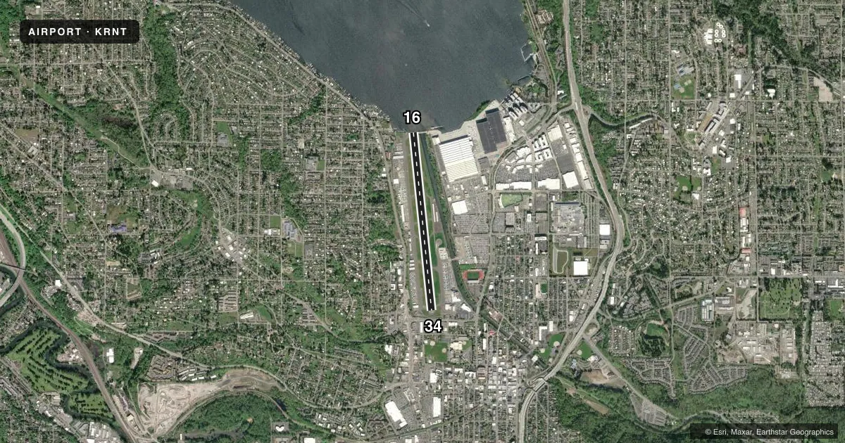
Runways & pattern
Full pagePattern entry · RWY 16
LEFT TRAFFICRunway end performance
| End | TORA | TODA | ASDA | LDA | VGSI | Approach lights | Obstruction |
|---|---|---|---|---|---|---|---|
| 16 | 5,382' | 5,382' | 5,042' | 4,742' | PAPI 2-box left(3.5°) | — | 290', trees, 10000' from thr, 0' R of cntrln, slope 33 |
| 34 | 5,382' | 5,382' | 5,082' | 4,742' | PAPI 2-box left(3.75°) | — | 15', road, 200' from thr, 0' R of cntrln, slope 0 |
Declared distances in feet. TORA = takeoff run available, TODA = takeoff distance, ASDA = accelerate-stop, LDA = landing distance.
Airport sketch
Runways drawn to scale from FAA survey coordinates, rendered over satellite imagery. Not for navigation.
Approaches & charts
Services on the field
Fuel grades, oxygen, maintenance, ramp storage and lighting — as declared to the FAA by the airport operator.
Fuel & services
- Fuel
- 100LLAA+
- Oxygen (bottled)
- HIGH/LOW
- Oxygen (bulk)
- HIGH/LOW
- Airframe repair
- Major
- Power plant repair
- Major
- Other services
- AVNCS,BCHGR,CHTR,INSTR,RNTL
Ramp & ground
- Transient storage
- Tie-down
- Landing fee
- No fee published
- Customs
- Not available
- Lighting schedule
- SEE RMK
- Beacon schedule
- SS-SR
- Beacon
- White / Green (civil land)(WG)
- Wind indicator
- Lighted
- Segmented circle
- No
Fuel & FBOs
Cheapest 100LL and Jet A on the field and nearby. Always confirm with the FBO before taxi.
Airport notes
Surface conditions, obstructions, local procedures, lighting outages and other notes published with each FAA cycle.
General notes
- NUMEROUS FLOCKS OF BIRDS INVOF ARPT & ALONG LAKE WASHINGTON SHORELINE AT ALL TIMES.
- WEST TWY CLSD TO ACFT WITH WING SPAN 118 FT OR OVR.
- AFIS (ADCUS) AVBL.
- BE ALERT FOR BOEING PRODUCTION ACFT BEING TOWED ACRS THE RY DURG HRS ATCT CLOSED.
- NOISE ABATEMENT PROC IN EFCT: CTC ADMIN 425-430-7471.
- SPB NW CORNER ARPT.
- RY 34 12 FT BLAST FENCE 155 FT FM EOR.
- TWY B BTN TWY B3 AND TWY B5 CLSD TO ACFT WITH WING SPAN 50 FT OR OVR.
- EMER FREQ 121.5 NOT MNT AT TWR.
- DURG RNT TWR HRS OF OPS AND VMC WX, RNT TWR HAS CTL OF THE WEST CHANNEL, OVR THE WATER BLO 800 FT AGL. IF OPR IN THE WEST CHANNEL ABV 800 FT AGL OR WHEN RNT ATCT CLSD, CTC BOEING TWR, 118.3, PRIOR TO OPR IN THE WEST CHANNEL.
- FOR CD WHEN ATCT IS CLSD CTC SEATTLE APCH AT 206-214-4722.
- WHEN ATCT CLSD RNAV (GPS) RWY 16 IS PREFERRED IAP.
Lighting notes
- ACTVT REIL RWY 16 & 34; MIRL RWY 16/34 AND TWY LGTS - CTAF. PAPI RWY 16 & 34 ON CONSLY.
Approach & departure obstructions
- 1610,000 FT FM RWY THR.
- 34APCH SLOPE 13:1 TO DTHR DUE TO 1323 FT TREE 442 FT LEFT OF CNTRLN; 17:1 TO DTHR DUE TO 933 FT TREE 180 FT LEFT OF CTRLN; 26:1 DUE TO 20 FT BLAST FENCE 530 FT FM DTHR.
Other notes
- ESTAB PRIOR TO 1959.
- TPA WEST OF THE ARPT IS 1218 FT AGL DUE TO TRRN IMTLY WEST OF THE ARPT.
- PILOTS PROVD OWN TIEDOWN CHAINS.
- ACFT RQRG SVCS CTC 122.85 OR 122.77.
- MANAGEREMAIL - MCRUZ@RENTONWA.GOV
VFR map & nearby airports
VFR sectional. Tap any ICAO chip to open that airport.
Key facts · KRNT
Answer card- ICAO
- KRNT
- Name
- RENTON MUNI
- Location
- RENTON, WASHINGTON
- Elevation
- 32 ft MSL
- Traffic pattern altitude
- 1,250 ft MSL (1,218 AGL)
- Control tower
- Towered · OCT 1-APR 30 0700-2000; MAY 1-SEP 30 0700-2100
- Total runways
- 1
- Longest runway
- 16/34 · 5,382 ft
- Published ILS approaches
- 0
- Published frequencies
- 49
- Magnetic variation
- 17°
- Current flight rules
- MVFR
- Current wind
- 180° at 7 kt
- Favored runway now
- RWY 16
Renton Muni sits in Renton, Washington, just south of Seattle on the east side of Lake Washington. Field elevation is 32 ft MSL. The airport has one runway, 16/34, which is 5,382 ft long. The tower is open daily. Hours are 0700-2000 from October 1 through April 30. Hours are 0700-2100 from May 1 through September 30. No ILS approaches are published here.
Pattern altitude is 1,250 ft MSL. That equals 1,218 ft AGL. West of the airport, the terrain drives that pattern altitude. Expect close-in traffic and pay attention to the west channel procedures over the water. During tower hours in VMC, Renton tower controls the west channel below 800 ft AGL. If you are above 800 ft AGL in the west channel or the tower is closed, contact Boeing tower on 118.3 before operating there.
Vesper Aviation is on the field. It carries 100LL, Jet A and Jet A Prist. Birds are a known factor around the airport and along the Lake Washington shoreline. Be alert for Boeing production aircraft being towed across the runway when the tower is closed. Runway 16 and 34 have runway end identifier lights, medium intensity runway lights and PAPI. The airport also has automatic flight information service with ADS-B support.