METAR & TAF KRNM
Current METAR
Observed 12:09Z
KRNM 271209Z AUTO 28003KT 1/4SM FG VV002 18/17 A2995 RMK AO2 T01780172 $
- Wind
- 280° @ 3 kt
- Visibility
- 0.25 SM
- Temp / Dew
- 18°C / 17°C
- Altimeter
- 29.95 inHg
- Clouds
- VV
- Density alt
- 2,052 ft
- Ceiling
- 200 ft AGL
- Rules
- LIFR
Airport info & contacts
Manager on record, flight service, ARTCC, attendance schedule and pattern altitude — published by the FAA and refreshed every 28 days.
Location
- From city
- 2 NM W
- VFR sectional
- LOS ANGELES
- ARTCC
- ZLA · LOS ANGELES
- NOTAM facility
- RNM (NOTAM-D)
Airport manager
- Name
- MEADOW CHASE
- Phone
- 760-788-3366
- Address
- 2926 MONTECITO ROAD, RAMONA CA 92065
Flight service · Hours
- FSS SAN
- SAN DIEGO1-800-WX-BRIEF
- Attendance
- 0800-2000
Frequencies
Tap any row to copy the frequency to your clipboard.
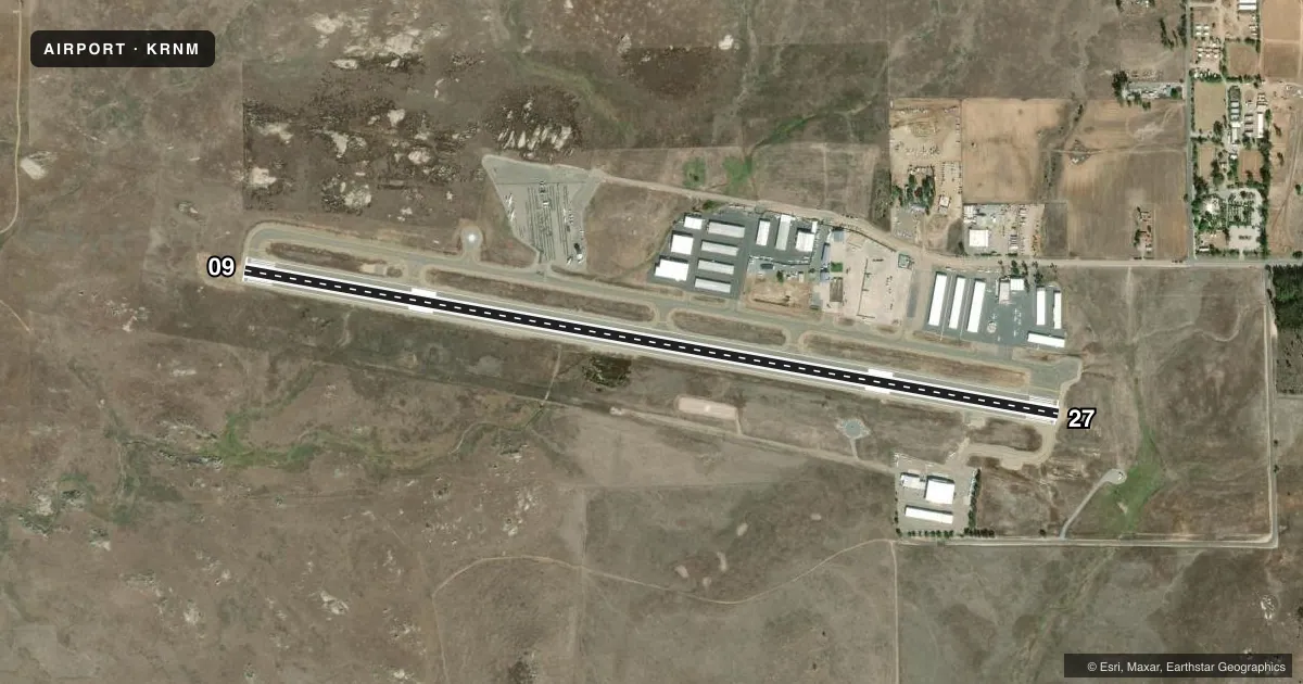
Runways & pattern
Full pagePattern entry · RWY 27
LEFT TRAFFICRunway end performance
| End | TORA | TODA | ASDA | LDA | VGSI | Approach lights | Obstruction |
|---|---|---|---|---|---|---|---|
| 09 | — | — | — | — | PAPI 2-box left(3.5°) | — | — |
| 27 | — | — | — | — | PAPI 2-box left(3.5°) | — | — |
Declared distances in feet. TORA = takeoff run available, TODA = takeoff distance, ASDA = accelerate-stop, LDA = landing distance.
Airport sketch
Runways drawn to scale from FAA survey coordinates, rendered over satellite imagery. Not for navigation.
Approaches & charts
Services on the field
Fuel grades, oxygen, maintenance, ramp storage and lighting — as declared to the FAA by the airport operator.
Fuel & services
- Fuel
- 100LLA
- Oxygen (bottled)
- Not available
- Oxygen (bulk)
- Not available
- Airframe repair
- Major
- Power plant repair
- Major
- Other services
- INSTR,RNTL,SALES
Ramp & ground
- Transient storage
- Tie-down
- Landing fee
- No fee published
- Customs
- Not available
- Lighting schedule
- SEE RMK
- Beacon schedule
- SS-SR
- Beacon
- White / Green (civil land)(WG)
- Wind indicator
- Lighted
- Segmented circle
- Yes
Fuel & FBOs
Cheapest 100LL and Jet A on the field and nearby. Always confirm with the FBO before taxi.
Airport notes
Surface conditions, obstructions, local procedures, lighting outages and other notes published with each FAA cycle.
General notes
- HELIPAD PRKG N OF RWY NOT OPEN TO PUB.
- VOLUNTARY JET CURFEW 2200-0700. NOISE SENSITIVE AREA NE-SE. NOISE ABATEMENT: TKOF CLIMB ON RWY HDG UNTIL 1900 FT MSL.
- FIRE FIGHTING ACFT ON AND IN THE VICINITY OF ARPT.
- AIR TANKERS IN VCNTY YEAR-ROUND FRQLY FLY NONSTD PAT ENTRIES.
- RWY 27 CALM WIND RWY.
- FOR FIRE FIGHTING ACTIVITY CALL AMGR.
- BE ALERT FOR BIRDS YEAR ROUND, VARIOUS SIZE AND SPECIES. OCNL COYOTE ON OR IN THE VICINITY OF RWY AND TWY.
- WHEN TWR CLSD ACFT MUST SELF-ANNOUNCE ON CTAF PRIOR TO LDG OR TKOF.
- PPR FOR ALL MIL ACFT CTC AMGR.
- COPTER SKID LNDGS ON RWY AND TWY PROHIBITED.
- HEL OPS TO HELIPAD S OF RWY RSTRD TO 6000 LBS OR LESS.
- REPETITIVE COPTER TRG CONDUCTED ON HELIPAD S OF RWY AND TWY A W OF TWR.
- HELIPAD S OF RWY UNLGTD.
- HELIPAD S OF RWY DAYTIME VFR USE ONLY.
- FOR CD WHEN ATCT CLSD CTC SOCAL APCH AT 800-448-3724.
- NO COPTER HOVER TAXI ON TWY A FROM TWY A1 UP TO, BUT NOT INCLG, TWY A4.
- PPR FOR ALL ACFT MORE THAN 65000 LBS AT WEST TSNT RAMP ADJ TO ATCT; CTC AMGR.
Lighting notes
- ACTVT REIL RWY 27; MIRL RWY 09/27; TWY LGTS - CTAF. PAPI RWYS 09 & 27 OPER CONSLY.
Approach & departure obstructions
- 09UNUSBL BYD 3.0 NM DUE TO TRRN.
Other notes
- 1000 FT SNGL ENG, 1500 FT MULT ENG.
- MANAGERARPT MGR: CAN ALSO BE REACHED AT FALLBROOK COMMUNITY AIRPARK 760-723-8395.
VFR map & nearby airports
VFR sectional. Tap any ICAO chip to open that airport.
Key facts · KRNM
Answer card- ICAO
- KRNM
- Name
- RAMONA
- Location
- RAMONA, CALIFORNIA
- Elevation
- 1,394.9 ft MSL
- Traffic pattern altitude
- 2,394.9 ft MSL (1,000 AGL)
- Control tower
- Towered · 0800-2000
- Total runways
- 1
- Longest runway
- 09/27 · 5,001 ft
- Published ILS approaches
- 0
- Published frequencies
- 15
- Magnetic variation
- 12°
- Current flight rules
- LIFR
- Current wind
- 280° at 3 kt
- Favored runway now
- RWY 27
Ramona Airport sits in Ramona, California. The field elevation is 1,394.6 ft MSL. It has one runway, 09/27, which is 5,001 ft long. The airport is towered from 0800 to 2000. No ILS approaches are published. Pattern altitude is not published, so use the standard 1,000 ft AGL for light piston operations unless the current Chart Supplement says otherwise.
The runway is aligned 09/27 with magnetic headings of 99° and 279°. Runway 27 is the calm wind runway. Runway 09 is unusable beyond 3.0 NM because of terrain. That matters here. The area has terrain. It also has year-round bird activity. Occasional coyotes have been reported near the runway and taxiway. Air tankers are in the vicinity year-round and often fly nonstandard pattern entries, so keep your scan sharp.
Two on-field FBOs are listed. Pacific Executive Aviation carries 100LL and Jet A. Chuck Hall Aviation carries 100LL and Jet A. The airport also has lighting details worth knowing. Runway end identifier lights are on runway 27. Medium intensity runway lights are on 09/27. Taxiway lights are controlled by CTAF. PAPI is available on both runway ends and operates 24 hours. Fire fighting aircraft are on and near the airport, so expect unusual traffic when that activity is active.