METAR & TAF KORK
Current METAR
Observed 18:15Z
KORK 271815Z AUTO 23009KT 10SM CLR 37/20 A2991 RMK AO2
- Wind
- 230° @ 9 kt
- Visibility
- 10 SM
- Temp / Dew
- 37°C / 20°C
- Altimeter
- 29.91 inHg
- Clouds
- CLR
- Density alt
- 3,329 ft
- Ceiling
- Unlimited
- Rules
- VFR
Airport info & contacts
Manager on record, flight service, ARTCC, attendance schedule and pattern altitude — published by the FAA and refreshed every 28 days.
Location
- From city
- 4 NM N
- VFR sectional
- MEMPHIS
- Pattern altitude
- 1,000 ft AGL · 1,545 ft MSL
- ARTCC
- ZME · MEMPHIS
- NOTAM facility
- JBR (NOTAM-D)
Airport manager
- Name
- VIRGINIA YOUNG
- Phone
- 501-835-5654
- Address
- 8240 REMOUNT ROAD, NORTH LITTLE ROCK AR 72118
Flight service · Hours
- FSS JBR
- JONESBORO1-800-WX-BRIEF
- Attendance
- 0600-2000
Frequencies
Tap any row to copy the frequency to your clipboard.
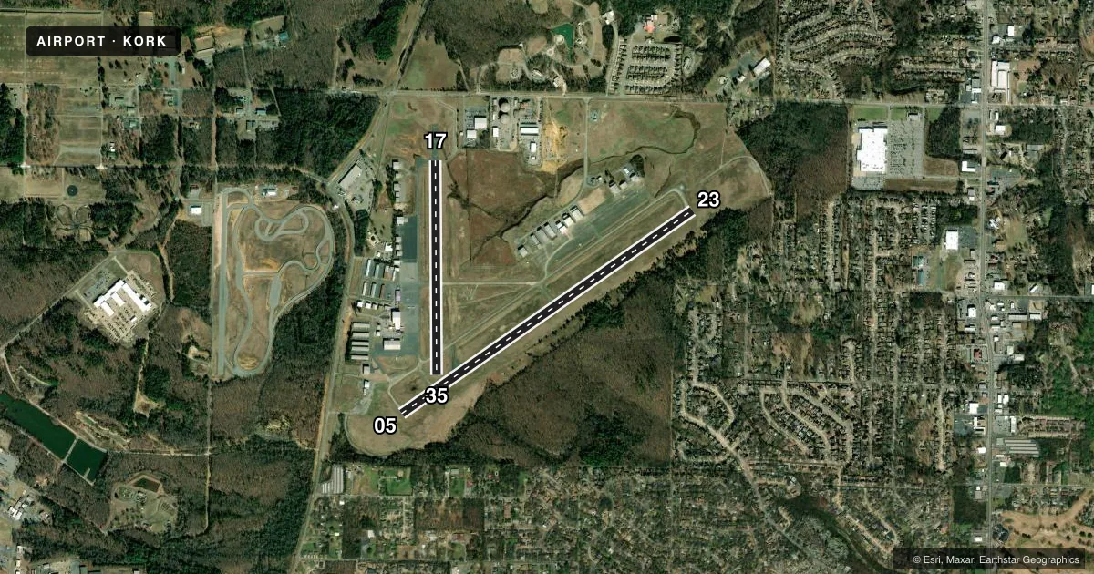
Runways & pattern
Full pagePattern entry · RWY 23
RIGHT TRAFFIC| Runway | Heading (°M) | Length | Surface | Traffic |
|---|---|---|---|---|
| 05/23Favored | 53° / 233° | 5,002 ft | CONC | 23 R |
| 17/35 | 178° / 358° | 3,019 ft | ASPH | 17 R |
Runway end performance
| End | TORA | TODA | ASDA | LDA | VGSI | Approach lights | Obstruction |
|---|---|---|---|---|---|---|---|
| 05 | — | — | — | — | PAPI 2-box right(3°) | — | 16', trees, 950' from thr, 100' R of cntrln, slope 46 |
| 23 | — | — | — | — | PAPI 2-box left(3°) | — | — |
| 17 | — | — | — | — | PAPI 2-box left(3°) | — | 12', gnd, 200' from thr, 200' R of cntrln, slope 0 |
| 35 | — | — | — | — | PAPI 2-box left(3°) | — | 26', trees, 1100' from thr, 0' R of cntrln, slope 34 |
Declared distances in feet. TORA = takeoff run available, TODA = takeoff distance, ASDA = accelerate-stop, LDA = landing distance.
Airport sketch
Runways drawn to scale from FAA survey coordinates, rendered over satellite imagery. Not for navigation.
Approaches & charts
ILS · 1
Services on the field
Fuel grades, oxygen, maintenance, ramp storage and lighting — as declared to the FAA by the airport operator.
Fuel & services
- Fuel
- 100LLA
- Oxygen (bottled)
- Not available
- Oxygen (bulk)
- Not available
- Airframe repair
- Major
- Power plant repair
- Major
- Other services
- CHTR,INSTR,RNTL,SALES
Ramp & ground
- Transient storage
- Tie-down
- Landing fee
- No fee published
- Customs
- Not available
- Lighting schedule
- SEE RMK
- Beacon schedule
- SS-SR
- Beacon
- White / Green (civil land)(WG)
- Wind indicator
- Lighted
- Segmented circle
- Yes
Fuel & FBOs
Cheapest 100LL and Jet A on the field and nearby. Always confirm with the FBO before taxi.
Airport notes
Surface conditions, obstructions, local procedures, lighting outages and other notes published with each FAA cycle.
General notes
- RY 23 THLD NOT VISIBLE FM RY 17 THLD.
- DEER ON & INVOF ARPT.
- RY 17/35 500 FT BLAST PAD NORTH END.
- FOR ARPT ACCESS CALL 501-835-5654; 501-529-1051
- ULTRALIGHT ACTIVITY ON & INVOF ARPT.
- FOR CD WHEN UNA VIA FREQ CTC LITTLE ROCK APCH 501-379-2908 OR LITTLE ROCK ATCT 501-379-2911
Lighting notes
- ACTVT REIL RWYS 05, 23, 17; MIRL RWYS 05/23 & 17/35 - CTAF. PAPI RWYS 05, 23, 17 & 35 OPR CONSLY.
Fuel notes
- 100LL100LL AVBL 24 HR SELF SERVICE WITH CREDIT CARD.
Approach & departure obstructions
- 17+12 FT BERM 100 FT FM RY END 200 FT L & R OF CNTRLN EXTENDED INTO PRIMARY SFC.
- 35CALM WIND PREFERRED TKOF/LNDG TO THE NORTH WHEN POSSIBLE.
Other notes
- TPA FOR HELS 500 FT AGL, PROP ACFT 1000 FT AGL, TURBOPROP ACFT 1500 FT AGL
VFR map & nearby airports
VFR sectional. Tap any ICAO chip to open that airport.
Key facts · KORK
Answer card- ICAO
- KORK
- Name
- NORTH LITTLE ROCK MUNI
- Location
- NORTH LITTLE ROCK, ARKANSAS
- Elevation
- 545.4 ft MSL
- Traffic pattern altitude
- 1,545.4 ft MSL (1,000 AGL)
- Control tower
- Non-towered (use CTAF)
- Total runways
- 2
- Longest runway
- 05/23 · 5,002 ft
- Published ILS approaches
- 1
- Published frequencies
- 5
- Magnetic variation
- 2°
- Current flight rules
- VFR
- Current wind
- 230° at 9 kt
- Favored runway now
- RWY 23
North Little Rock Muni sits in North Little Rock, Arkansas. Field elevation is 545.4 ft MSL. The airport has 2 runways. The longest is runway 05/23 at 5,002 ft. There is no control tower. The pattern altitude for propeller aircraft is 1,545.4 ft MSL. That is 1,000 ft AGL. Helicopters use 500 ft AGL. Turboprops use 1,500 ft AGL.
Runway 05 has the published ILS approach. The field also has runway lighting that is controlled via CTAF. PAPI is reported as operating continuously on runways 05, 23, 17 and 35. One thing to brief early is the local traffic picture. Ultralight activity occurs on and near the airport. Deer are also present on and near the field. Runway 17 has a berm near the departure end. Runway 23 threshold is not visible from the runway 17 threshold.
Two on-field FBOs are listed. North Little Rock Air carries 100LL and Jet A. North Little Rock Jet Center carries 100LL and Jet A. 100LL is also available 24 hours self-serve with credit card. For access or clearance help when frequency contact is not available, use the airport phone numbers in the Chart Supplement or call Little Rock Approach. Check current runway lighting. Check traffic flow and any local operating notes before departure.