METAR & TAF KOGS
Current METAR
Observed 20:35Z
KOGS 272035Z AUTO 00000KT 10SM CLR 26/20 A2971 RMK AO2
- Wind
- 000° @ 0 kt
- Visibility
- 10 SM
- Temp / Dew
- 26°C / 20°C
- Altimeter
- 29.71 inHg
- Clouds
- CLR
- Density alt
- 1,955 ft
- Ceiling
- Unlimited
- Rules
- VFR
Airport info & contacts
Manager on record, flight service, ARTCC, attendance schedule and pattern altitude — published by the FAA and refreshed every 28 days.
Location
- From city
- 2 NM SE
- VFR sectional
- MONTREAL
- ARTCC
- ZBW · BOSTON
- NOTAM facility
- OGS (NOTAM-D)
Airport manager
- Name
- CHARLIE GARRELTS
- Phone
- (315) 869-2676
- Address
- 5840 STATE HWY 812, OGDENSBURG NY 13669
Flight service · Hours
- FSS BTV
- BURLINGTON1-800-WX-BRIEF
- Attendance
- NOV 15 - APR 14 · 0600-2030
- 0630-1930
Frequencies
Tap any row to copy the frequency to your clipboard.
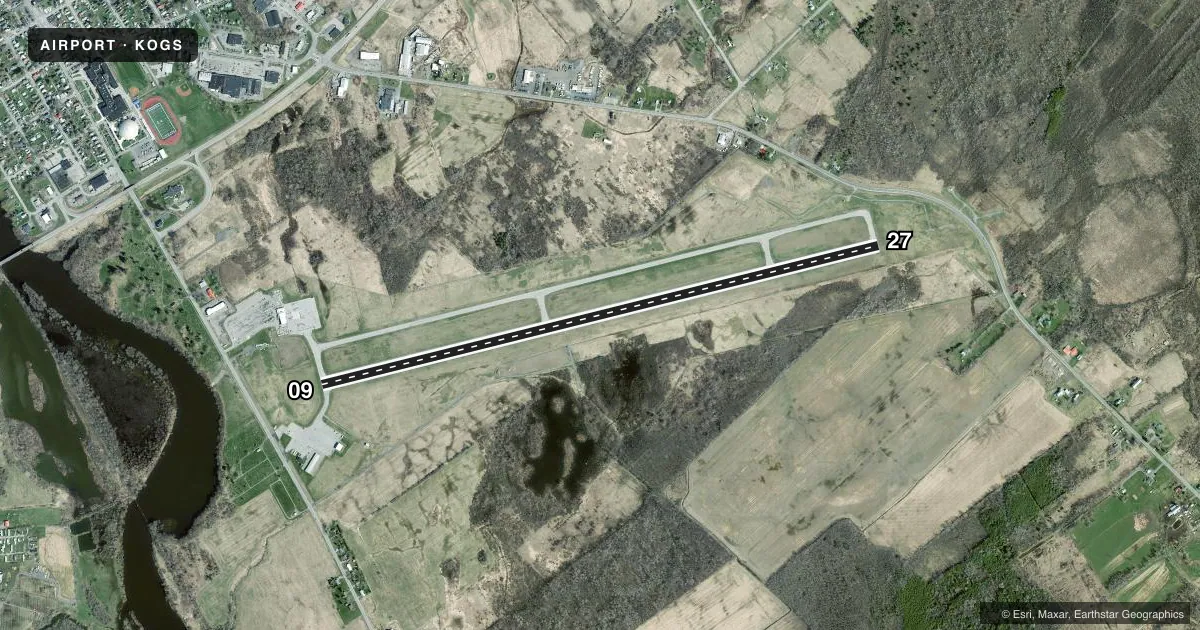
Runways & pattern
Full pagePattern entry · RWY 09
LEFT TRAFFICRunway end performance
| End | TORA | TODA | ASDA | LDA | VGSI | Approach lights | Obstruction |
|---|---|---|---|---|---|---|---|
| 09 | 6,400' | 6,400' | 6,006' | 6,006' | PAPI 4-box left(3°) | — | — |
| 27 | 6,400' | 6,400' | 6,035' | 6,035' | PAPI 4-box left(3°) | MALSF | — |
Declared distances in feet. TORA = takeoff run available, TODA = takeoff distance, ASDA = accelerate-stop, LDA = landing distance.
Airport sketch
Runways drawn to scale from FAA survey coordinates, rendered over satellite imagery. Not for navigation.
Approaches & charts
ILS · 1
Services on the field
Fuel grades, oxygen, maintenance, ramp storage and lighting — as declared to the FAA by the airport operator.
Fuel & services
- Fuel
- 100LLA
- Oxygen (bottled)
- Not available
- Oxygen (bulk)
- Not available
- Other services
- INSTR,RNTL
Ramp & ground
- Transient storage
- Tie-down
- Landing fee
- Yes
- Customs
- Available
- Lighting schedule
- SEE RMK
- Beacon schedule
- SS-SR
- Beacon
- White / Green (civil land)(WG)
- Wind indicator
- Lighted
- Segmented circle
- No
Fuel & FBOs
Cheapest 100LL and Jet A on the field and nearby. Always confirm with the FBO before taxi.
Airport notes
Surface conditions, obstructions, local procedures, lighting outages and other notes published with each FAA cycle.
General notes
- BIRDS & DEER ON & INVOF ARPT.
- FOR CD IF UNA TO CTC ON FSS FREQ, CTC BOSTON ARTCC AT 603-879-6859 .
- RWY/TWY/APN COND NOT MONITORED OUTSIDE NML ATTENDANCE HRS.
Lighting notes
- ACTVT MALSF RWY 27; HIRL RWY 09/27; TWY LGTS - CTAF. PAPI RWY 09 & 27 OPR CONSLY.
Fuel notes
- 100LLFUEL AVBL AFT 1600 CALL 315-869-2676.
Runway surface & condition
- 09/27PCR VALUE: 523/F/D/X/T
Other notes
- FILED FOR RECORD PURPOSES ONLY.
- FREE EXCEPT SUN AFTER 0000 & HOL.
- PPR 24 HRS FOR UNSKED ACR OPS WITH MORE THAN 30 PAX SEATS, CALL AMGR. ARFF INDEX B COVERAGE IS AVBL UPON REQ.
- ACFT APCHING FROM THE WEST AND LDG ON RWY 09 SHOULD MNT BROCKVILLE ARPT (CNL3) UNICOM ON 123.0.
VFR map & nearby airports
VFR sectional. Tap any ICAO chip to open that airport.
Key facts · KOGS
Answer card- ICAO
- KOGS
- Name
- OGDENSBURG INTL
- Location
- OGDENSBURG, NEW YORK
- Elevation
- 301.8 ft MSL
- Traffic pattern altitude
- 1,301.8 ft MSL (1,000 AGL)
- Control tower
- Non-towered (use CTAF)
- Total runways
- 1
- Longest runway
- 09/27 · 6,400 ft
- Published ILS approaches
- 1
- Published frequencies
- 2
- Magnetic variation
- 13°
- Current flight rules
- VFR
- Current wind
- 000° at 0 kt
- Favored runway now
- –
Ogdensburg Intl is in Ogdensburg, New York near the St. Lawrence River. Field elevation is 301.8 ft MSL. The airport has one runway, 09/27, which is 6,400 ft long. There is no control tower. Use CTAF 122.8 for traffic calls and UNICOM 122.8 for the same frequency.
An ILS is published for runway 27. The lighting setup matters here. MALSR is active on runway 27. High intensity runway lights are on both runway ends. Taxiway lights are controlled by CTAF. PAPI on runways 09 and 27 operate continuously. Pattern altitude is not published, so use the standard 1,000 ft AGL for light piston aircraft unless the current Chart Supplement says otherwise.
Ogdensburg Bridge & Port Authority is on the field. It carries 100LL, Jet A and Jet A Prist. Fuel is available after 1600. Call ahead if you need an attendant after 2000. Published remarks also call out birds and deer in the airport area, so plan your scan on taxi and final. Aircraft approaching from the west and landing runway 09 should monitor Brockville Airport UNICOM on 123.0. For larger unscheduled aircraft with more than 30 passenger seats, prior permission is required 24 hours in advance. Check the current Chart Supplement for any noise or curfew restrictions before flying into the field.