METAR & TAF KMAL
KMAL does not publish a METAR.
Showing the nearest reporting station: KMSS (MASSENA INTL-RICHARDS FLD) · 22.5 NM away. Conditions at KMAL may differ.
METAR · KMSS
Observed 17:53Z
KMSS 271753Z AUTO 23009KT 10SM CLR 29/18 A2976 RMK AO2 LTG DSNT NW SLP076 T02890183 10289 20200 56015
- Wind
- 230° @ 9 kt
- Visibility
- 10 SM
- Temp / Dew
- 29°C / 18°C
- Altimeter
- 29.76 inHg
- Clouds
- CLR
- Density alt
- 2,858 ft
- Ceiling
- Unlimited
- Rules
- VFR
Airport info & contacts
Manager on record, flight service, ARTCC, attendance schedule and pattern altitude — published by the FAA and refreshed every 28 days.
Location
- From city
- 2 NM W
- VFR sectional
- MONTREAL
- ARTCC
- ZBW · BOSTON
- NOTAM facility
- BTV (NOTAM-D)
Airport manager
- Name
- BRUCE BURDITT
- Phone
- (518) 483-4740
- Address
- 27 AIRPORT ROAD, MALONE NY 12953
Flight service · Hours
- FSS BTV
- BURLINGTON1-800-WX-BRIEF
Frequencies
Tap any row to copy the frequency to your clipboard.
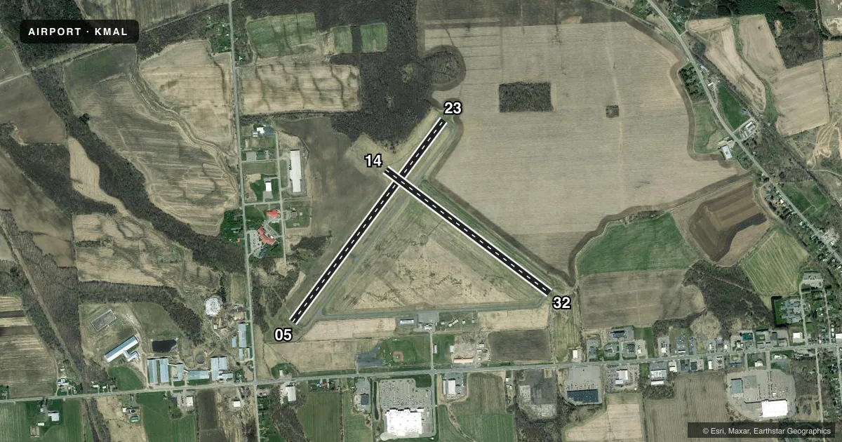
Runways & pattern
Full pagePattern entry · RWY 23
LEFT TRAFFIC| Runway | Heading (°M) | Length | Surface | Traffic |
|---|---|---|---|---|
| 05/23Favored | 22° / 202° | 3,994 ft | ASPH | Standard L |
| 14/32 | 112° / 292° | 3,250 ft | ASPH | Standard L |
Runway end performance
| End | TORA | TODA | ASDA | LDA | VGSI | Approach lights | Obstruction |
|---|---|---|---|---|---|---|---|
| 05 | 3,994' | 3,994' | 3,994' | 3,994' | PAPI 2-box left(3.15°) | — | 16', trees, 262' from thr, 172' R of cntrln, slope 3 |
| 23 | 3,994' | 3,994' | 3,994' | 3,994' | PAPI 2-box left(3°) | — | 52', trees, 696' from thr, 322' R of cntrln, slope 9 |
| 14 | 3,250' | 3,250' | 3,250' | 3,250' | — | — | 30', trees, 815' from thr, 144' R of cntrln, slope 20 |
| 32 | 3,250' | 3,250' | 3,250' | 2,902' | — | — | 34', tree, 203' from thr, 85' R of cntrln, slope 0 |
Declared distances in feet. TORA = takeoff run available, TODA = takeoff distance, ASDA = accelerate-stop, LDA = landing distance.
Airport sketch
Runways drawn to scale from FAA survey coordinates, rendered over satellite imagery. Not for navigation.
Approaches & charts
Services on the field
Fuel grades, oxygen, maintenance, ramp storage and lighting — as declared to the FAA by the airport operator.
Fuel & services
- Fuel
- 100LL
- Oxygen (bottled)
- Not available
- Oxygen (bulk)
- Not available
- Airframe repair
- Not available
- Power plant repair
- Not available
Ramp & ground
- Transient storage
- Tie-down
- Landing fee
- No fee published
- Customs
- Not available
- Lighting schedule
- SEE RMK
- Beacon schedule
- SS-SR
- Beacon
- White / Green (civil land)(WG)
- Wind indicator
- Lighted
- Segmented circle
- Yes
Fuel & FBOs
Cheapest 100LL and Jet A on the field and nearby. Always confirm with the FBO before taxi.
Airport notes
Surface conditions, obstructions, local procedures, lighting outages and other notes published with each FAA cycle.
General notes
- HAYING ACTIVITY & EQUIPMENT PRESENT JUN - SEP.
- RY 14/32 HAS SNOW REMOVAL BUT VISUAL INSPECTION & NOTAM CHECK MUST BE DONE AS TOWN ROADS ARE PLOWED BEFORE ARPT.
- FOR CD CTC BOSTON ARTCC AT 603-879-6859.
- AIRPORT NOT ATTENDED
Lighting notes
- ACTVT PAPI RWY 05 & 23, MIRL RWY 05/23, 14/32 & TWY LGTS - CTAF.
Approach & departure obstructions
- 32APCH SLOPE 21:1, DUE TO +72 FT BLDG, 1572 FT FM DSPLCD THLD; +38 FT TREES, 805 FT FM DSPLCD THLD.
Other notes
- FILED FOR RECORD PURPOSES ONLY.
VFR map & nearby airports
VFR sectional. Tap any ICAO chip to open that airport.
Key facts · KMAL
Answer card- ICAO
- KMAL
- Name
- MALONE-DUFORT
- Location
- MALONE, NEW YORK
- Elevation
- 789.9 ft MSL
- Traffic pattern altitude
- 1,789.9 ft MSL (1,000 AGL)
- Control tower
- Non-towered (use CTAF)
- Total runways
- 2
- Longest runway
- 05/23 · 3,994 ft
- Published ILS approaches
- 0
- Published frequencies
- 2
- Magnetic variation
- 15°
- Current flight rules
- VFR
- Current wind
- 230° at 9 kt
- Favored runway now
- RWY 23
Malone-Dufort Airport sits in Malone, New York at 789.9 ft MSL. It has two asphalt runways. The longest is 05/23 at 3,994 ft. The other runway is 14/32 at 3,250 ft. The field is not towered. CTAF and UNICOM are both 122.8.
No ILS approaches are published here. Pattern altitude is not published, so use the standard 1,000 ft AGL for light piston operations unless the current Chart Supplement says otherwise. The on-field FBO is Malone-Dufort Airport. It carries AVGAS 100LL. Call (518) 483-5073 before you go if you need current service details.
This is a field where the remarks matter. Runway 32 has a 72-foot building and trees on the approach path. Runway 14 has crops close to the threshold. There is also an 18-foot road with tall farm equipment near the runway centerline on the 32 side. The airport is not attended. Haying activity and equipment are present from June through September. Runway lights and PAPI are available on 05/23. Medium intensity runway lights are also on both runways. Snow removal is noted on 14/32, but you still need a visual inspection and a current NOTAM check before using it. For clearance delivery, contact Boston ARTCC.