METAR & TAF KMSS
Current METAR
Observed 17:53Z
KMSS 271753Z AUTO 23009KT 10SM CLR 29/18 A2976 RMK AO2 LTG DSNT NW SLP076 T02890183 10289 20200 56015
- Wind
- 230° @ 9 kt
- Visibility
- 10 SM
- Temp / Dew
- 29°C / 18°C
- Altimeter
- 29.76 inHg
- Clouds
- CLR
- Density alt
- 2,153 ft
- Ceiling
- Unlimited
- Rules
- VFR
Airport info & contacts
Manager on record, flight service, ARTCC, attendance schedule and pattern altitude — published by the FAA and refreshed every 28 days.
Location
- From city
- 2 NM E
- VFR sectional
- MONTREAL
- ARTCC
- ZBW · BOSTON
- NOTAM facility
- MSS (NOTAM-D)
Airport manager
- Name
- DYLAN CASSELMAN
- Phone
- 315-769-7605
- Address
- 90 AVIATION ROAD, MASSENA NY 13662
Flight service · Hours
- FSS BTV
- BURLINGTON1-800-WX-BRIEF
- Attendance
- MON-FRI · 0400-1700
- SAT-SUN · 0700-0800
Frequencies
Tap any row to copy the frequency to your clipboard.
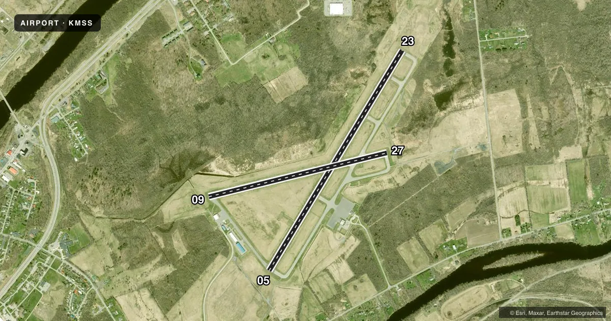
Runways & pattern
Full pagePattern entry · RWY 23
LEFT TRAFFIC| Runway | Heading (°M) | Length | Surface | Traffic |
|---|---|---|---|---|
| 05/23Favored | 17° / 197° | 5,601 ft | ASPH | Standard L |
| 09/27 | 62° / 242° | 4,000 ft | ASPH | Standard L |
Runway end performance
| End | TORA | TODA | ASDA | LDA | VGSI | Approach lights | Obstruction |
|---|---|---|---|---|---|---|---|
| 05 | 5,601' | 5,601' | 5,601' | 5,601' | PAPI 4-box left(3°) | — | 52', pole, 1649' from thr, 430' R of cntrln, slope 32 |
| 23 | 5,601' | 5,601' | 5,601' | 5,601' | PAPI 4-box left(3°) | — | — |
| 09 | 4,000' | 4,000' | 4,000' | 4,000' | — | — | 88', trees, 1764' from thr, 365' R of cntrln, slope 20 |
| 27 | 4,000' | 4,000' | 4,000' | 4,000' | PAPI 4-box left(3°) | — | — |
Declared distances in feet. TORA = takeoff run available, TODA = takeoff distance, ASDA = accelerate-stop, LDA = landing distance.
Airport sketch
Runways drawn to scale from FAA survey coordinates, rendered over satellite imagery. Not for navigation.
Approaches & charts
ILS · 1
Services on the field
Fuel grades, oxygen, maintenance, ramp storage and lighting — as declared to the FAA by the airport operator.
Fuel & services
- Fuel
- 100LLA
- Oxygen (bottled)
- Not available
- Oxygen (bulk)
- Not available
- Airframe repair
- Minor
- Power plant repair
- Not available
- Other services
- AFRT,CARGO,CHTR
Ramp & ground
- Transient storage
- Tie-down
- Hangar
- Landing fee
- Yes
- Customs
- Available
- Lighting schedule
- SEE RMK
- Beacon schedule
- SS-SR
- Beacon
- White / Green (civil land)(WG)
- Wind indicator
- Lighted
- Segmented circle
- No
Fuel & FBOs
Cheapest 100LL and Jet A on the field and nearby. Always confirm with the FBO before taxi.
Airport notes
Surface conditions, obstructions, local procedures, lighting outages and other notes published with each FAA cycle.
General notes
- FREQUENT CONCENTRATION OF SEAGULLS AND CANADA GEESE ON AND INVOF ARPT PARTICULARLY DURG POOR WX PERIODS.
- 421 FT LGTD/MKD TWR 6000 FT S OF ARPT.
- BIRDS & DEER ON & INVOF ARPT.
- RY CONDS RPRTD DUR NML HRS OF OPN.
- OVERNIGHT ACFT PARKING AVBL AT TERMINAL APRON.
- AFTER ATTENDANCE HRS VEHICLE & PEDESTRIAN ACCESS TO FBO APRON & HANGAR ONLY AVBL WITH KEY CARD FOR AUTOMATIC GATE.
- COMMUTER AIRCRAFT SECURE AREA CLOSED TO GENERAL AVIATION AIRCRAFT CLEARING CUSTOMS. PARKING AVAILABLE TO RIGHT OF TERMINAL BUILDING.
- CTN NVD OPS CONDUCTED PERIODICALLY IN ARPT TFC PAT AREA.
- MIL HEL TRNG ON & INVOF ARPT.
- FOR CD IF UNA TO CTC ON FSS FREQ, CTC BOSTON ARTCC AT 603-879-6859 .
- INDEX A COVERAGE AVBL DURG ATNDC HRS. FOR EMERGS OUTSIDE OF ATNDC HRS, CALL ST LAWRENCE CO EMERG SVCS AT 911.
Lighting notes
- ACTVT REIL RWY 05, 09 & 27; PAPI RWY 23, 27; HIRL RWY 05/23; MIRL RWY 09/27; TWY LGTS - CTAF. PAPI RWY 05 OPR CONSLY.
Runway surface & condition
- 05/23PCR VALUE: 360/F/D/X/T
- 09/27PCR VALUE: 343/F/D/X/T
Other notes
- FILED FOR RECORD PURPOSES ONLY.
- PPR 24 HRS FOR ACFT OPS WITH MORE THAN 30 PAX SEATS CALL AMGR (315) 769-7605.
- 05/23RWY 05 FIRST 50 FT NOT GRVD.
- 09/27RWY 09 FIRST 50 FT NOT GRVD. RWY 27 FIRST 50 FT NOT GRVD.
VFR map & nearby airports
VFR sectional. Tap any ICAO chip to open that airport.
Key facts · KMSS
Answer card- ICAO
- KMSS
- Name
- MASSENA INTL-RICHARDS FLD
- Location
- MASSENA, NEW YORK
- Elevation
- 221.5 ft MSL
- Traffic pattern altitude
- 1,221.5 ft MSL (1,000 AGL)
- Control tower
- Non-towered (use CTAF)
- Total runways
- 2
- Longest runway
- 05/23 · 5,601 ft
- Published ILS approaches
- 1
- Published frequencies
- 2
- Magnetic variation
- 14°
- Current flight rules
- VFR
- Current wind
- 230° at 9 kt
- Favored runway now
- RWY 23
Massena Intl-Richards Fld sits in Massena, New York, near the Canadian border. Field elevation is 221.5 ft MSL. The airport has two asphalt runways. The longest is runway 05/23 at 5,601 ft. This is an uncontrolled field. CTAF and UNICOM are both 123.0. The published pattern altitude is not listed, so use the standard 1,000 ft AGL for light piston traffic unless the current Chart Supplement says otherwise.
Runway 05 has an ILS. That is the only published ILS here. Runway 05/23 also has high intensity lighting. Runway 09/27 has medium intensity lighting. Runway end identifier lights are installed on 05, 09 and 27. The airport also has a 421-foot lighted and marked tower 6,000 ft south of the field. Keep that in mind on departure and in the pattern. Birds, geese and deer are reported in and around the airport. That matters here, especially in poor weather. Night vision device operations also happen periodically in the traffic pattern area.
Massena International Airport is the on-field FBO. It carries AVGAS 100LL and Jet A. Clearance delivery can be routed through Boston ARTCC if flight service is not available. For aircraft with more than 30 passenger seats, prior permission is required 24 hours in advance. Parking for customs arrivals is to the right of the terminal building. After attendance hours, access to the FBO apron and hangar needs a key card at the automatic gate.