METAR & TAF 1E8
1E8 does not publish a METAR.
Showing the nearest reporting station: KPTD (POTSDAM MUNI/DAMON FLD) · 18.1 NM away. Conditions at 1E8 may differ.
METAR · KPTD
Observed 17:15Z
KPTD 271715Z AUTO 23004KT 10SM CLR 28/19 A2978 RMK AO2 PNO
- Wind
- 230° @ 4 kt
- Visibility
- 10 SM
- Temp / Dew
- 28°C / 19°C
- Altimeter
- 29.78 inHg
- Clouds
- CLR
- Density alt
- 2,744 ft
- Ceiling
- Unlimited
- Rules
- VFR
Airport info & contacts
Manager on record, flight service, ARTCC, attendance schedule and pattern altitude — published by the FAA and refreshed every 28 days.
Location
- From city
- 3 NM N
- VFR sectional
- MONTREAL
- ARTCC
- ZBW · BOSTON
- NOTAM facility
- BTV (NOTAM-D)
Airport manager
- Name
- ROBIN CELLECK
- Phone
- (315) 379-1907
- Address
- 4482 CO. RT 27, CANTON NY 13617
Flight service · Hours
- FSS BTV
- BURLINGTON1-800-WX-BRIEF
- Attendance
- Unattended
Frequencies
Tap any row to copy the frequency to your clipboard.
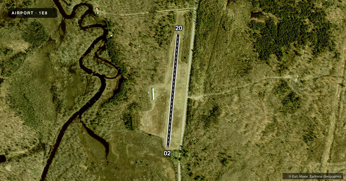
Runways & pattern
Full pagePattern entry · RWY 20
LEFT TRAFFICRunway end performance
| End | TORA | TODA | ASDA | LDA | VGSI | Approach lights | Obstruction |
|---|---|---|---|---|---|---|---|
| 02 | — | — | — | — | — | — | 37', trees, 32' from thr, 88' R of cntrln, slope 0 |
| 20 | — | — | — | — | — | — | 42', trees, 112' from thr, 112' R of cntrln, slope 2 |
Declared distances in feet. TORA = takeoff run available, TODA = takeoff distance, ASDA = accelerate-stop, LDA = landing distance.
Airport sketch
Runways drawn to scale from FAA survey coordinates, rendered over satellite imagery. Not for navigation.
Approaches & charts
Services on the field
Fuel grades, oxygen, maintenance, ramp storage and lighting — as declared to the FAA by the airport operator.
Fuel & services
- Fuel
- Not available
- Oxygen (bottled)
- Not available
- Oxygen (bulk)
- Not available
- Airframe repair
- Not available
- Power plant repair
- Not available
Ramp & ground
- Transient storage
- Tie-down
- Landing fee
- No fee published
- Customs
- Not available
- Wind indicator
- Yes
- Segmented circle
- No
Fuel & FBOs
Cheapest 100LL and Jet A on the field and nearby. Always confirm with the FBO before taxi.
Airport notes
Surface conditions, obstructions, local procedures, lighting outages and other notes published with each FAA cycle.
General notes
- DEER ON AND INVOF ARPT.
- 2 FT DITCH IMT RT OF THLD MKD BY CONES.
- RY 20, 58 FT TREES, 263 FT FM RY BEGINNING, ACROSS RY WIDTH & APPROXIMATELY 800 FT. ALONG BOTH SIDES.
- DIRT ROAD TO HANGAR CROSSES APPROXIMATE MIDPOINT OF RY.
- RWY 20 3 EARTHEN MOUNDS APPROX. 5 FT. HIGH OFF RIGHT SIDE OF RUNWAY 400 FT. FROM THRESHOLD. TREES/BRUSH NEXT TO RUNWAY THRESHOLD L/S.
- RWY 02 TREES/BRUSH NEXT TO CORNER OF THRESHOLD L/S.
- FOR CD CTC BOSTON ARTCC AT 603-879-6859.
Runway surface & condition
- 02/20RY 20 STARTS AT APPROX 250 FT FM TREES ON RY END.
Approach & departure obstructions
- 02CONTROLLING OBSTRUCTION EXCEEDS A 45 DEGREE SLOPE
Other notes
- AIRSPACE DETERMINATION PENDING.
VFR map & nearby airports
VFR sectional. Tap any ICAO chip to open that airport.
Key facts · 1E8
Answer card- ICAO
- 1E8
- Name
- DEGRASSE MOORES
- Location
- DEGRASSE, NEW YORK
- Elevation
- 815 ft MSL
- Traffic pattern altitude
- 1,815 ft MSL (1,000 AGL)
- Control tower
- Non-towered (use CTAF)
- Total runways
- 1
- Longest runway
- 02/20 · 2,200 ft
- Published ILS approaches
- 0
- Published frequencies
- 1
- Magnetic variation
- 14°
- Current flight rules
- VFR
- Current wind
- 230° at 4 kt
- Favored runway now
- RWY 20
DEGRASSE MOORES is in Degrasse, New York. Field elevation is 815 ft MSL. The airport has one runway. Runway 02/20 is 2,200 ft of turf, so plan for soft-field performance and keep runway condition in mind. There is no control tower. CTAF is 122.9.
No ILS approaches are published here. Pattern altitude is not published, so use the standard 1,000 ft AGL for light piston operations unless the current FAA Chart Supplement says otherwise. Airspace determination is pending, so check the current sectional or TAC before you go. The published remarks matter here. Runway 20 has mounds, a ditch near the threshold, trees and brush near both ends and a dirt road crossing near midfield. Deer are also reported on and near the airport. Runway 20 also has trees close off the departure end. That makes a careful arrival and a conservative go-around plan a good idea.
There are no on-field FBOs listed. Contact the airport operator directly before arrival. Call the field on CTAF for current local information. For clearance delivery, the published contact is Boston ARTCC at 603-879-6859.