METAR & TAF KMEV
Current METAR
Observed 13:35Z
KMEV 271335Z AUTO 17003KT 10SM CLR 08/00 A3017 RMK AO2
- Wind
- 170° @ 3 kt
- Visibility
- 10 SM
- Temp / Dew
- 8°C / 0°C
- Altimeter
- 30.17 inHg
- Clouds
- CLR
- Density alt
- 4,707 ft
- Ceiling
- Unlimited
- Rules
- VFR
Airport info & contacts
Manager on record, flight service, ARTCC, attendance schedule and pattern altitude — published by the FAA and refreshed every 28 days.
Location
- From city
- 4 NM N
- VFR sectional
- SAN FRANCISCO
- ARTCC
- ZOA · OAKLAND
- NOTAM facility
- MEV (NOTAM-D)
Airport manager
- Name
- HEATHER MACDONNELL
- Phone
- 775-782-9871
- Address
- 1146 AIRPORT ROAD, MINDEN NV 89423
Flight service · Hours
- FSS RNO
- RENO1-800-WX-BRIEF
- Attendance
- MON-FRI · 0730-1600
Frequencies
Tap any row to copy the frequency to your clipboard.
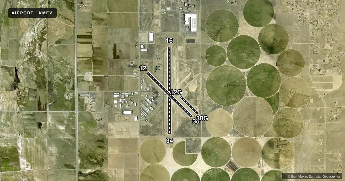
Runways & pattern
Full pagePattern entry · RWY 16
RIGHT TRAFFIC| Runway | Heading (°M) | Length | Surface | Traffic |
|---|---|---|---|---|
| 16/34Favored | 165° / 345° | 7,399 ft | ASPH | 16 R |
| 12/30 | 120° / 300° | 5,299 ft | ASPH | 12 R |
| 12G/30G | 120° / 300° | 2,050 ft | DIRT | Standard L |
Runway end performance
| End | TORA | TODA | ASDA | LDA | VGSI | Approach lights | Obstruction |
|---|---|---|---|---|---|---|---|
| 16 | — | — | — | — | VASI 4-box right(3°) | — | — |
| 34 | — | — | — | — | VASI 4-box left(3°) | — | — |
| 12 | — | — | — | — | — | — | 60', tree, 1430' from thr, 30' R of cntrln, slope 20 |
Declared distances in feet. TORA = takeoff run available, TODA = takeoff distance, ASDA = accelerate-stop, LDA = landing distance.
Airport sketch
Runways drawn to scale from FAA survey coordinates, rendered over satellite imagery. Not for navigation.
Approaches & charts
Services on the field
Fuel grades, oxygen, maintenance, ramp storage and lighting — as declared to the FAA by the airport operator.
Fuel & services
- Fuel
- 100LLA
- Oxygen (bottled)
- High pressure
- Airframe repair
- Major
- Power plant repair
- Major
- Other services
- AGRI,AVNCS,CHTR,GLD,INSTR,RNTL,SALES,TOW
Ramp & ground
- Transient storage
- Tie-down
- Hangar
- Landing fee
- No fee published
- Customs
- Not available
- Lighting schedule
- SEE RMK
- Beacon schedule
- SS-SR
- Beacon
- White / Green (civil land)(WG)
- Wind indicator
- Lighted
- Segmented circle
- Yes
Fuel & FBOs
Cheapest 100LL and Jet A on the field and nearby. Always confirm with the FBO before taxi.
Airport notes
Surface conditions, obstructions, local procedures, lighting outages and other notes published with each FAA cycle.
General notes
- GLIDER, ULTRALIGHT, SKYDIVING, SAILPLANE AND BALLOON ACT ON AND INVOF ARPT.
- EMERG AFT 1700 - 775-782-5126.
- SNOW REMOVAL DURG DALGT ONLY.
- NOISE ABATEMENT PROC IN EFCT - 775-782-9871.
- TREES 1,440 FT FROM APCH END RY 12. DITCH IN OBSTACLE FREE ZONE ADJ SW END TWY C. MEN & EQUIPMENT OCCASIONLY ON RWYS AND TWYS.
- MOWERS INVOF ARPT & RWYS.
- FOR CD CTC NORCAL APCH AT 916-361-6874.
Lighting notes
- ACTVT REIL RWY 16 & 34; VASI RWY 16 & 34; HIRL RWY 16/34 - CTAF.
Runway surface & condition
- 12/30PCR VALUE: 10/F/C/X/T
- 16/34PCR VALUE: 40/F/C/X/T
- 12G/30GRWY 30G LNDG ONLY; RWY 12G TKOF & LNDG NA.
Approach & departure obstructions
- 30SAILPLANE PAT RT TFC.
- 34SAILPLANE PAT RT TFC.
- 30GTHR MKD WITH ORANGE & WHITE PANELS.
VFR map & nearby airports
VFR sectional. Tap any ICAO chip to open that airport.
Key facts · KMEV
Answer card- ICAO
- KMEV
- Name
- MINDEN-TAHOE
- Location
- MINDEN, NEVADA
- Elevation
- 4,723.6 ft MSL
- Traffic pattern altitude
- 5,723.6 ft MSL (1,000 AGL)
- Control tower
- Non-towered (use CTAF)
- Total runways
- 3
- Longest runway
- 16/34 · 7,399 ft
- Published ILS approaches
- 0
- Published frequencies
- 5
- Magnetic variation
- 15°
- Current flight rules
- VFR
- Current wind
- 170° at 3 kt
- Favored runway now
- RWY 16
Minden-Tahoe Airport is in Minden, Nevada. The field elevation is 4,723.6 ft MSL, so density altitude can matter even on a normal day. KMEV has three runways. The longest is runway 16/34 at 7,399 ft. Runway 12/30 is 5,299 ft asphalt. Runway 12G/30G is a 2,050 ft dirt strip. There is no control tower. CTAF and UNICOM are both 123.05. No ILS approaches are published, so plan with current weather and the latest approach data before you go.
The published pattern altitude is not listed. Use the standard 1,000 ft AGL pattern for light piston aircraft unless the current Chart Supplement or local procedures say otherwise. Hutt Aviation is on the field. It carries 100LL and Jet A. Call ahead on (775) 782-8277 for current service details. Published remarks also note noise abatement procedures, so check the current Chart Supplement or call the airport operator before arrival. There is also mixed traffic on and near the airport, including gliders, ultralights, skydiving, sailplanes and balloons. Runway 30 has right traffic for sailplanes. Runway 34 also has right traffic for sailplanes. Runway 16/34 has high-intensity lights, REILs and VASI. Runway 30G is landing only. Runway 12G is not authorized for takeoff or landing. Trees are 1,440 ft from the approach end of runway 12. Men and equipment are occasionally on runways and taxiways.