METAR & TAF KMDH
Current METAR
Observed 15:52Z
KMDH 271552Z 24007KT 10SM CLR 31/22 A2989
- Wind
- 240° @ 7 kt
- Visibility
- 10 SM
- Temp / Dew
- 31°C / 22°C
- Altimeter
- 29.89 inHg
- Clouds
- CLR
- Density alt
- 2,467 ft
- Ceiling
- Unlimited
- Rules
- VFR
Airport info & contacts
Manager on record, flight service, ARTCC, attendance schedule and pattern altitude — published by the FAA and refreshed every 28 days.
Location
- From city
- 3 NM NW
- VFR sectional
- ST LOUIS
- ARTCC
- ZKC · KANSAS CITY
- NOTAM facility
- MDH (NOTAM-D)
Airport manager
- Name
- ALYSSA CONNELL
- Phone
- 618-529-1721
- Address
- P O BOX 1086, CARBONDALE IL 62903
Flight service · Hours
- FSS STL
- SAINT LOUIS1-800-WX-BRIEF
- Attendance
- ALL
Frequencies
Tap any row to copy the frequency to your clipboard.
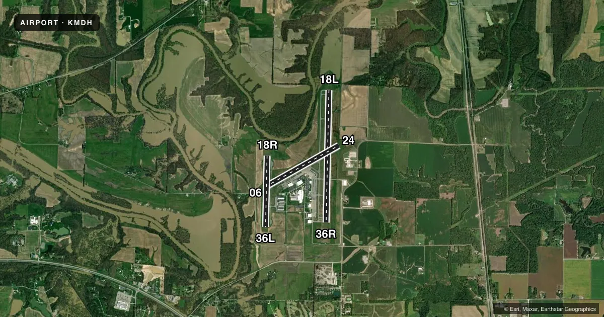
Runways & pattern
Full pagePattern entry · RWY 24
LEFT TRAFFIC| Runway | Heading (°M) | Length | Surface | Traffic |
|---|---|---|---|---|
| 18L/36R | 180° / 0° | 6,506 ft | ASPH | Standard L |
| 06/24Favored | 60° / 240° | 4,163 ft | ASPH | Standard L |
| 18R/36L | 180° / 0° | 3,498 ft | ASPH | Standard L |
Runway end performance
| End | TORA | TODA | ASDA | LDA | VGSI | Approach lights | Obstruction |
|---|---|---|---|---|---|---|---|
| 18L | 6,506' | 6,506' | 6,506' | 6,506' | — | MALSR | — |
| 36R | 6,506' | 6,506' | 6,506' | 6,506' | PAPI 4-box left(3°) | — | — |
| 06 | 4,163' | 4,163' | 4,163' | 4,163' | VASI 4-box left(3.5°) | — | — |
| 24 | 4,163' | 4,163' | 4,163' | 4,163' | PAPI 4-box right(3.5°) | — | — |
| 18R | 3,498' | 3,498' | 3,498' | 3,498' | PSIL(3°) | — | — |
| 36L | 3,498' | 3,498' | 3,498' | 3,498' | PSIL(3°) | — | — |
Declared distances in feet. TORA = takeoff run available, TODA = takeoff distance, ASDA = accelerate-stop, LDA = landing distance.
Airport sketch
Runways drawn to scale from FAA survey coordinates, rendered over satellite imagery. Not for navigation.
Approaches & charts
ILS · 1
Services on the field
Fuel grades, oxygen, maintenance, ramp storage and lighting — as declared to the FAA by the airport operator.
Fuel & services
- Fuel
- 100LLA
- Oxygen (bottled)
- Not available
- Oxygen (bulk)
- Not available
- Airframe repair
- Major
- Power plant repair
- Major
- Other services
- AMB,CARGO,CHTR,INSTR,RNTL,SALES
Ramp & ground
- Transient storage
- Tie-down
- Hangar
- Landing fee
- No fee published
- Customs
- Not available
- Lighting schedule
- SEE RMK
- Beacon schedule
- SS-SR
- Beacon
- White / Green (civil land)(WG)
- Wind indicator
- Lighted
- Segmented circle
- Yes
Fuel & FBOs
Cheapest 100LL and Jet A on the field and nearby. Always confirm with the FBO before taxi.
Airport notes
Surface conditions, obstructions, local procedures, lighting outages and other notes published with each FAA cycle.
General notes
- BIRDS ON & INVOF ARPT.
- HIGH STUDENT TRNG ACTVTY.
- RWY 6 & RWY 18R-36L INTERSECT; VERIFY CORRECT COMPASS HDG FOR RWY 6 DEP.
Lighting notes
- ACTVT MALSR RWY 18L; VASI RWY 06; PAPI RWY 24 & 36R; MIRL RWY 06/24; HIRL RWY 18L/36R - CTAF. WHEN ATCT CLSD HIRL RWY 18L/36R PRESET MED INTST; INCREASE INTST - CTAF. WHEN ATCT CLSD 18R/36L LTG BY REQUEST ONLY - CALL 618-534-3662.
Runway surface & condition
- 06/24RSTRD TO ACFT 12500 LBS OR LESS UNLESS PPR WITH ATCT.
- 06/24PCR VALUE: 350/F/D/X/T
- 18L/36RPCR VALUE: 270/F/D/X/T
- 18R/36LPCR VALUE: 40/F/D/X/T
- 06/24RWY 06/24 NOT AVBL FOR PART 121/PART 380 OPS WITH SKED PAX CARRYING OPS MORE THAN 9 PAX SEATS AND NON-SKED PAX CARRYING OPS MORE THAN 30 PAX SEATS.
- 18R/36LRWY 18R/36L NOT AVBL FOR PART 121/PART 380 OPS WITH SKED PAX CARRYING OPS MORE THAN 9 PAX SEATS AND NON-SKED PAX CARRYING OPS MORE THAN 30 PAX SEATS.
Approach & departure obstructions
- 18RUNUSBL BYD 6 DEG RIGHT OF COURSE. PVASI OTS INDEF.
- 36R39 FT MKD PLINE 1872 FT FM RWY 192 FT L OF CNTRLN. APCH RATIO 42:1.
Other notes
- CLSD TO SKED ACR OPS GTR THAN 9 PSGR SEATS. UNSKED ACR OPS GTR THAN 30 PSGR SEATS RQR 24 HR PPR - CALL AMGR MON-FRI.
VFR map & nearby airports
VFR sectional. Tap any ICAO chip to open that airport.
Key facts · KMDH
Answer card- ICAO
- KMDH
- Name
- SOUTHERN ILLINOIS
- Location
- CARBONDALE/MURPHYSBORO, ILLINOIS
- Elevation
- 411.2 ft MSL
- Traffic pattern altitude
- 1,411.2 ft MSL (1,000 AGL)
- Control tower
- Towered · 0700-2100
- Total runways
- 3
- Longest runway
- 18L/36R · 6,506 ft
- Published ILS approaches
- 1
- Published frequencies
- 7
- Magnetic variation
- 1°
- Current flight rules
- VFR
- Current wind
- 240° at 7 kt
- Favored runway now
- RWY 24
Southern Illinois Airport sits in Carbondale and Murphysboro, Illinois. Field elevation is 411.2 ft MSL. The airport has 3 asphalt runways. The longest is 18L/36R at 6,506 ft. The tower is open 0700-2100. One ILS is published for runway 18L. Pattern altitude is not published, so use the standard 1,000 ft AGL for light piston traffic unless ATC or the current Chart Supplement says otherwise.
Flightline is on the field. It carries 100LL and Jet A with Prist. If you are planning a stop, that is the confirmed fuel source to call first. The airport sees high student training activity. Birds are also reported on and near the field, so expect extra scan work in the pattern and on departure.
Runway 18L/36R is the main paved runway for longer arrivals. Runway 18R/36L is shorter and has a marked power line near the approach end. Runway 06/24 is available too, but it is restricted to aircraft 12,500 lb or less unless the tower gives prior permission. Runway 06 and 18R/36L intersect, so verify the correct heading before a 06 departure. If you need lighting details after tower hours, check the current Chart Supplement or call the airport operator. The field also has published restrictions for larger scheduled and unscheduled passenger operations.