METAR & TAF KMCW
Current METAR
Observed 19:53Z
KMCW 271953Z AUTO 32013KT 10SM CLR 32/21 A2975 RMK AO2 SLP057 T03220211
- Wind
- 320° @ 13 kt
- Visibility
- 10 SM
- Temp / Dew
- 32°C / 21°C
- Altimeter
- 29.75 inHg
- Clouds
- CLR
- Density alt
- 3,755 ft
- Ceiling
- Unlimited
- Rules
- VFR
Airport info & contacts
Manager on record, flight service, ARTCC, attendance schedule and pattern altitude — published by the FAA and refreshed every 28 days.
Location
- From city
- 5 NM W
- VFR sectional
- OMAHA
- Pattern altitude
- 800 ft AGL · 2,013 ft MSL
- ARTCC
- ZMP · MINNEAPOLIS
- NOTAM facility
- MCW (NOTAM-D)
Airport manager
- Name
- DAVID K. SIMS
- Phone
- 641-421-3397
- Address
- 9184 - 265TH STREET, CLEAR LAKE IA 50428-1484
Flight service · Hours
- FSS FOD
- FORT DODGE1-800-WX-BRIEF
- Attendance
- 0700-1700
Frequencies
Tap any row to copy the frequency to your clipboard.
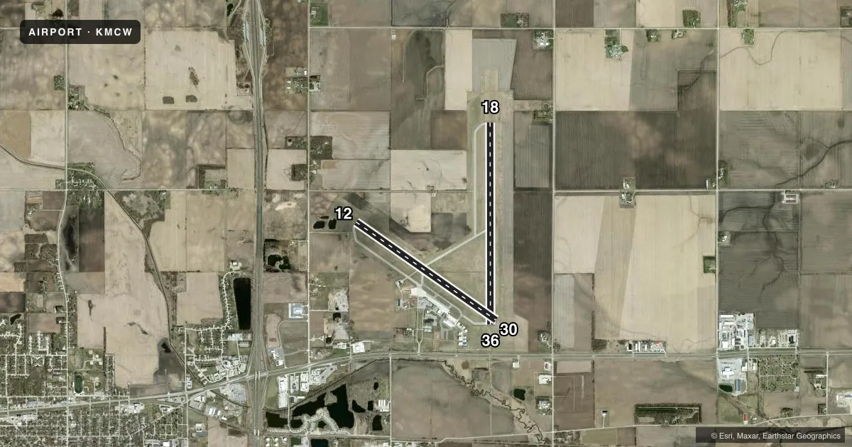
Runways & pattern
Full pagePattern entry · RWY 30
LEFT TRAFFIC| Runway | Heading (°M) | Length | Surface | Traffic |
|---|---|---|---|---|
| 18/36 | 180° / 0° | 6,501 ft | ASPH | Standard L |
| 12/30Favored | 125° / 305° | 5,502 ft | ASPH | Standard L |
Runway end performance
| End | TORA | TODA | ASDA | LDA | VGSI | Approach lights | Obstruction |
|---|---|---|---|---|---|---|---|
| 18 | 6,501' | 6,501' | 6,501' | 6,501' | VASI 4-box left(3°) | MALS | — |
| 36 | 6,501' | 6,501' | 6,401' | 6,401' | PAPI 4-box left(2.9°) | MALSR | — |
| 12 | 5,501' | 5,501' | 5,501' | 5,501' | PAPI 4-box left(3°) | — | 63', tree, 1700' from thr, 150' R of cntrln, slope 23 |
| 30 | 5,501' | 5,501' | 5,501' | 5,501' | PAPI 4-box left(3°) | — | 41', bldg, 1650' from thr, 450' R of cntrln, slope 35 |
Declared distances in feet. TORA = takeoff run available, TODA = takeoff distance, ASDA = accelerate-stop, LDA = landing distance.
Airport sketch
Runways drawn to scale from FAA survey coordinates, rendered over satellite imagery. Not for navigation.
Approaches & charts
ILS · 1
Services on the field
Fuel grades, oxygen, maintenance, ramp storage and lighting — as declared to the FAA by the airport operator.
Fuel & services
- Fuel
- 100LLA
- Airframe repair
- Major
- Power plant repair
- Major
- Other services
- AMB,CHTR,INSTR,RNTL
Ramp & ground
- Transient storage
- Tie-down
- Hangar
- Landing fee
- No fee published
- Customs
- Not available
- Lighting schedule
- SEE RMK
- Beacon schedule
- SS-SR
- Beacon
- White / Green (civil land)(WG)
- Wind indicator
- Lighted
- Segmented circle
- Yes
Fuel & FBOs
Cheapest 100LL and Jet A on the field and nearby. Always confirm with the FBO before taxi.
Airport notes
Surface conditions, obstructions, local procedures, lighting outages and other notes published with each FAA cycle.
General notes
- BIRD ACTVTY ON & INVOF ARPT.
- LANDING FEE FOR ALL COMMERCIAL OPERATED ACFT.
- DUE TO RY & TWY END ELEV DIFFERENTIALS & ACFT HEIGHT; PILOTS MAY LOSE LINE OF SIGHT OF OTHER ACFT ON OPPOSING RY & TWY ENDS. ALL DEP/ARR ACFT USE CTAF.
- RY 30 IS CALM WIND RY.
- AIRPORT OPERATIONS 641-430-0980.
- FOR CD IF UNA TO CTC ON FSS FREQ, CTC MINNEAPOLIS ARTCC AT 651-463-5588.
Lighting notes
- ACTVT HIRL RY 18/36; MIRL RY 12/30; REIL RY 12; MALS RY 18; MALSR RY 36; VASI RY 18; PAPI RYS 12; 30; & 36 - CTAF. ALL PAPIS ON DURG DALGT HRS.
Runway surface & condition
- 12/30PCR VALUE: 160/F/C/X/T
- 18/36PCR VALUE: 610/F/C/X/T
Other notes
- INDEX C AVAILABLE PPR CTC ARPT OPS 641-430-0980.
- 1FOR SVC OR FUEL AFT HRS PPR CALL 641-430-9898.
- MANAGERAIRPORT ADDRESS
- OWNERCITY HALL ADDRESS
VFR map & nearby airports
VFR sectional. Tap any ICAO chip to open that airport.
Key facts · KMCW
Answer card- ICAO
- KMCW
- Name
- MASON CITY MUNI
- Location
- MASON CITY, IOWA
- Elevation
- 1,213.4 ft MSL
- Traffic pattern altitude
- 2,013.4 ft MSL (800 AGL)
- Control tower
- Non-towered (use CTAF)
- Total runways
- 2
- Longest runway
- 18/36 · 6,501 ft
- Published ILS approaches
- 1
- Published frequencies
- 2
- Magnetic variation
- 0°
- Current flight rules
- VFR
- Current wind
- 320° at 13 kt
- Favored runway now
- RWY 30
Mason City Muni is in Mason City, Iowa. The field elevation is 1,213.4 ft MSL. It has two asphalt runways. The longest is runway 18/36 at 6,501 ft. There is no control tower, so traffic stays on CTAF 123.0. Pattern altitude is 800 ft AGL, which is 2,013.4 ft MSL.
The airport has one ILS approach. It serves runway 36. North Iowa Air Service is on the field. It carries 100LL and Jet A Prist. Bird activity is reported on and near the airport, so keep a sharp scan on arrival and departure. The published remarks also warn that runway and taxiway end elevation differences can block line of sight between aircraft on opposite ends. That matters here because everyone is working the common traffic advisory frequency.
Runway 18 has high intensity lighting. Runway 12/30 has medium intensity lighting. Runway 18 has a medium intensity approach lighting system. Runway 36 has medium intensity approach lighting with runway alignment indicator lights. PAPI is published on runways 12, 30 and 36. For a first-time arrival, plan for an uncontrolled field with active lighting options. One ILS is available. A calm wind runway on 30 may be useful. If you need after-hours service or fuel, prior permission is required.