METAR & TAF KLXT
Current METAR
Observed 21:53Z
KLXT 272153Z AUTO 23014KT 10SM CLR 37/22 A2980 RMK AO2 PK WND 21026/2133 SLP077 T03670217
- Wind
- 230° @ 14 kt
- Visibility
- 10 SM
- Temp / Dew
- 37°C / 22°C
- Altimeter
- 29.80 inHg
- Clouds
- CLR
- Density alt
- 4,034 ft
- Ceiling
- Unlimited
- Rules
- VFR
Airport info & contacts
Manager on record, flight service, ARTCC, attendance schedule and pattern altitude — published by the FAA and refreshed every 28 days.
Location
- From city
- 3 NM N
- VFR sectional
- KANSAS CITY
- Pattern altitude
- 1,000 ft AGL · 2,004 ft MSL
- ARTCC
- ZKC · KANSAS CITY
- NOTAM facility
- LXT (NOTAM-D)
Airport manager
- Name
- JOEL ARRINGTON
- Phone
- 816-969-1186
- Address
- 2720 NE HAGAN RD, LEES SUMMIT MO 64064
Flight service · Hours
- FSS COU
- COLUMBIA1-800-WX-BRIEF
- Attendance
- 0600-2000
Frequencies
Tap any row to copy the frequency to your clipboard.
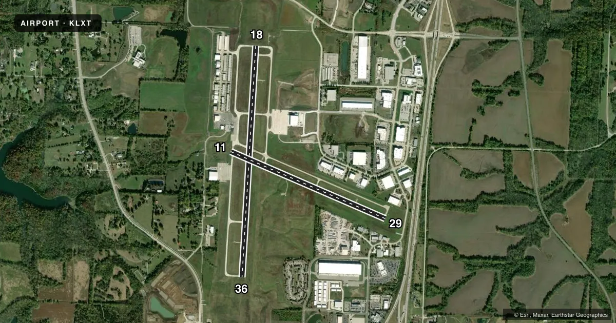
Runways & pattern
Full pagePattern entry · RWY 18
LEFT TRAFFIC| Runway | Heading (°M) | Length | Surface | Traffic |
|---|---|---|---|---|
| 18/36Favored | 181° / 1° | 5,501 ft | CONC | 36 R |
| 11/29 | 111° / 291° | 4,000 ft | CONC | 11 R |
Runway end performance
| End | TORA | TODA | ASDA | LDA | VGSI | Approach lights | Obstruction |
|---|---|---|---|---|---|---|---|
| 18 | — | — | — | — | PAPI 4-box left(3°) | — | — |
| 36 | — | — | — | — | PAPI 4-box left(3°) | — | — |
| 11 | — | — | — | — | PAPI 4-box left(3°) | — | — |
| 29 | — | — | — | — | PAPI 4-box right(3°) | — | — |
Declared distances in feet. TORA = takeoff run available, TODA = takeoff distance, ASDA = accelerate-stop, LDA = landing distance.
Airport sketch
Runways drawn to scale from FAA survey coordinates, rendered over satellite imagery. Not for navigation.
Approaches & charts
Services on the field
Fuel grades, oxygen, maintenance, ramp storage and lighting — as declared to the FAA by the airport operator.
Fuel & services
- Fuel
- 100LLAMOGAS
- Oxygen (bottled)
- Low pressure
- Oxygen (bulk)
- Not available
- Airframe repair
- Major
- Power plant repair
- Major
- Other services
- AVNCS,INSTR,RNTL,SALES,SURV
Ramp & ground
- Transient storage
- Tie-down
- Hangar
- Landing fee
- No fee published
- Customs
- Not available
- Lighting schedule
- SEE RMK
- Beacon schedule
- SS-SR
- Beacon
- White / Green (civil land)(WG)
- Wind indicator
- Lighted
- Segmented circle
- Yes
Fuel & FBOs
Cheapest 100LL and Jet A on the field and nearby. Always confirm with the FBO before taxi.
Airport notes
Surface conditions, obstructions, local procedures, lighting outages and other notes published with each FAA cycle.
General notes
- NO RIGHT TURNS UNDER 2500 FT MSL OR WITHIN 3 MI OF ARPT WHEN DEPARTING ON RWY 29.
- WILDLIFE ON & INVOF ARPT.
- WHEN WINDS ARE LESS THAN 5 KNOTS USE RWY 18.
- AER 18,36 & 29 ARE NOT MUTUALLY VSB DUE TO TRRN.
- ARPT TRML BLDG OPEN 24 HRS.
- RWY 18/36 GRAD 0.16%, RWY 11/29 GRAD 0.24%
- FOR CD CTC KANSAS CITY APCH 118.45 OR 816-329-2710.
- NO TOUCH-AND-GOES BTN 10 P.M. AND 7 A.M.
- REPEATED TKOF AND LNDGS BTN 10 P.M. AND 7 A.M. NEED TO BE TO A FULL STOP AND TAXI BACK.
- NO MID-FLD/INT DEP
- FLT TRNG ACFT ON RWY 36 MAKE CROSSWIND TURN AT 1500 MSL OR PRIOR TO WOODS CHAPEL RD, WHICHEVER OCCURS FIRST
- FLT TRNG ACFT ON RWY 18 MAKE CROSSWIND TURN AT 1500 MSL OR PRIOR TO HOSPITAL, WHICHEVER OCCURS FIRST.
Lighting notes
- ACTVT REIL RWY 18 & 36, 11 & 29; MIRL RWY 11 & 29, 18 & 36 - CTAF. PAPI RWY 11 & 29, 18 & 36 OPR CONSLY.
Fuel notes
- 100LL24 HR SELF SERVICE FUEL 100LL & MOGAS. MOBILE FUEL JET A AND 100LL. AFTER HRS FUEL CALL 816-969-1186. CALL OUT FEE.
Other notes
- TPA ACFT UNDER 6,000 LBS 1000 FT AGL, ACFT OVER 6,000 LBS 1,500 FT AGL.
- CTC AMGR FOR RAMP FEES.
VFR map & nearby airports
VFR sectional. Tap any ICAO chip to open that airport.
Key facts · KLXT
Answer card- ICAO
- KLXT
- Name
- KANSAS CITY/LEE'S SUMMIT RGNL
- Location
- LEE'S SUMMIT, MISSOURI
- Elevation
- 1,004.1 ft MSL
- Traffic pattern altitude
- 2,004.1 ft MSL (1,000 AGL)
- Control tower
- Non-towered (use CTAF)
- Total runways
- 2
- Longest runway
- 18/36 · 5,501 ft
- Published ILS approaches
- 0
- Published frequencies
- 5
- Magnetic variation
- 2°
- Current flight rules
- VFR
- Current wind
- 230° at 14 kt
- Favored runway now
- RWY 18
Kansas City/Lee's Summit Rgnl sits in Lee's Summit, Missouri. Field elevation is 1,004.1 ft MSL. The airport has two concrete runways. The longest is 18/36 at 5,501 ft. There is no control tower. No ILS approaches are published here.
Pattern altitude is 1,000 ft AGL for aircraft under 6,000 lb. That works out to 2,004.1 ft MSL. For aircraft over 6,000 lb, the published pattern altitude is 1,500 ft AGL. The field uses CTAF 122.8. UNICOM is also 122.8. Kansas City Approach handles clearance delivery on 118.45.
Lee's Summit Municipal Airport is the on-field FBO. It carries 100LL, Jet A Prist and mogas. The field also has 24-hour self-serve 100LL and mogas. Mobile fuel for Jet A and 100LL is available. After-hours fuel service requires a call to the FBO. A call-out fee applies.
A few local items matter on the first visit. When winds are less than 5 knots, runway 18 is the preferred runway. Repeated takeoffs and landings between 10 p.m. and 7 a.m. must be full stop and taxi back. Wildlife is reported on and near the airport. Runway 18/36 and 11/29 both have PAPI and medium-intensity lighting controlled by CTAF. The airport is busy enough that the published departure and training notes are worth reading before you go.