METAR & TAF KLUK
Current METAR
Observed 13:21Z
KLUK 271321Z 00000KT 2SM BR BKN003 21/21 A2994 RMK AO2 T02110211
- Wind
- 000° @ 0 kt
- Visibility
- 2 SM
- Temp / Dew
- 21°C / 21°C
- Altimeter
- 29.94 inHg
- Clouds
- BKN
- Density alt
- 1,292 ft
- Ceiling
- 300 ft AGL
- Rules
- LIFR
Airport info & contacts
Manager on record, flight service, ARTCC, attendance schedule and pattern altitude — published by the FAA and refreshed every 28 days.
Location
- From city
- 3 NM SE
- VFR sectional
- CINCINNATI
- ARTCC
- ZID · INDIANAPOLIS
- NOTAM facility
- LUK (NOTAM-D)
Airport manager
- Name
- SETH TIMMERMAN
- Phone
- 513-352-6340
- Address
- 465 WILMER AVE, CINCINNATI OH 45226-1833
Flight service · Hours
- FSS DAY
- DAYTON1-800-WX-BRIEF
- Attendance
- ALL
Frequencies
Tap any row to copy the frequency to your clipboard.
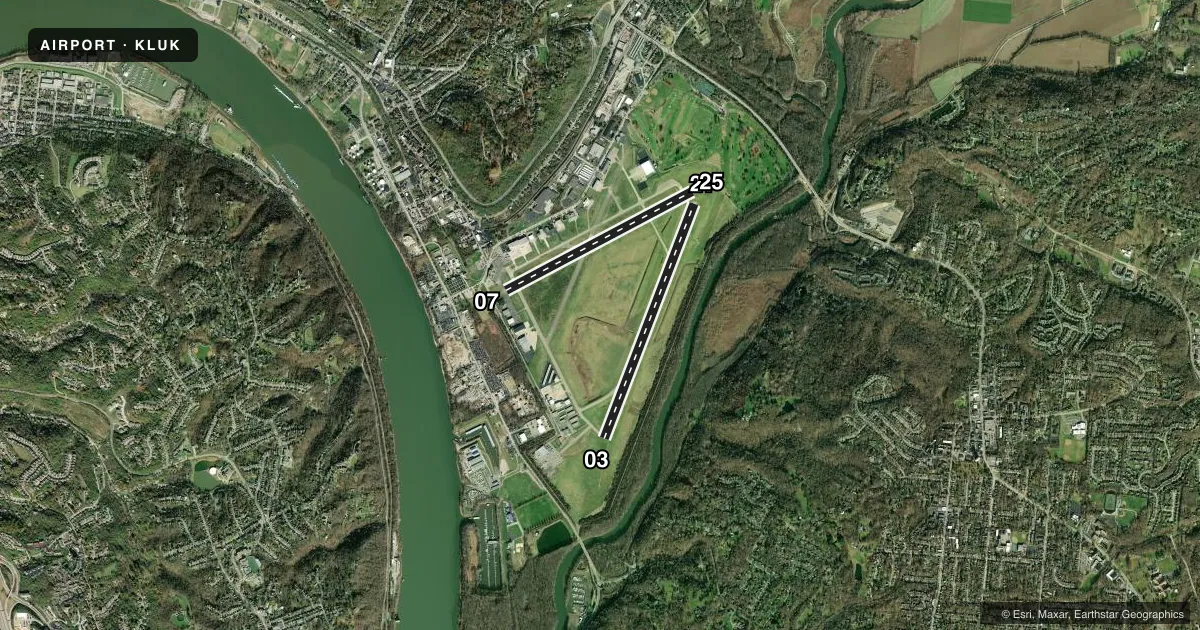
Runways & pattern
Full pagePattern entry · RWY 03
LEFT TRAFFIC| Runway | Heading (°M) | Length | Surface | Traffic |
|---|---|---|---|---|
| 03/21 | 17° / 197° | 6,101 ft | ASPH | Standard L |
| 07/25 | 58° / 238° | 5,127 ft | ASPH | Standard L |
Runway end performance
| End | TORA | TODA | ASDA | LDA | VGSI | Approach lights | Obstruction |
|---|---|---|---|---|---|---|---|
| 03 | 6,101' | 6,101' | 6,101' | 6,101' | PAPI 4-box right(3°) | — | 106', tree, 2094' from thr, 734' R of cntrln, slope 17 |
| 21 | 6,101' | 6,101' | 6,101' | 6,101' | PAPI 4-box left(3°) | MALSR | 47', tree, 962' from thr, 605' R of cntrln, slope 16 |
| 07 | — | — | — | — | — | — | 30', bldg, 210' from thr, 167' R of cntrln, slope 0 |
| 25 | — | — | — | — | VASI 4-box left(3°) | — | 57', tree, 1261' from thr, 254' R of cntrln, slope 18 |
Declared distances in feet. TORA = takeoff run available, TODA = takeoff distance, ASDA = accelerate-stop, LDA = landing distance.
Airport sketch
Runways drawn to scale from FAA survey coordinates, rendered over satellite imagery. Not for navigation.
Approaches & charts
ILS · 1
Services on the field
Fuel grades, oxygen, maintenance, ramp storage and lighting — as declared to the FAA by the airport operator.
Fuel & services
- Fuel
- 100LLA+
- Oxygen (bulk)
- High pressure
- Airframe repair
- Major
- Power plant repair
- Major
- Other services
- AMB,AVNCS,CHTR,INSTR,SALES
Ramp & ground
- Transient storage
- Tie-down
- Landing fee
- Yes
- Customs
- Not available
- Lighting schedule
- SEE RMK
- Beacon schedule
- SS-SR
- Beacon
- White / Green (civil land)(WG)
- Wind indicator
- Lighted
- Segmented circle
- No
Fuel & FBOs
Cheapest 100LL and Jet A on the field and nearby. Always confirm with the FBO before taxi.
Airport notes
Surface conditions, obstructions, local procedures, lighting outages and other notes published with each FAA cycle.
General notes
- DEER & BIRDS ON & INVOF ARPT.
- CLSD TO SKEDD ACR OPS GTR THAN 9 PAX SEATS. 48 HR PPR FOR UNSKED ACR OPS WITH GTR THAN 30 PAX SEATS CALL AMGR.
- NOISE ABATEMENT PROCS IN EFCT CALL AMGR. ACFT MAINT RUNUPS RSTRD BTN 2100-0700.
- AER 25 & 21 ARE CLOSELY LCTD; VFY COR RWY WITH COMPASS HDG BFR DEP.
- TWY D, E, G, & H CLSD TO UNSKED ACR OPS GTR THAN 30 PAX SEATS.
- ARPT SFC COND UNMON DLY 2300-0700.
- TWY H NOT VSB FM ATCT, CTC GC. WHEN ATCT CLSD, USE CTAF.
- CUST IN TEMPO FAC; CUST FAC REQS MUST BE SMTD TO ARPT FIRST BY CALLING 513-709-2761 OR EMAIL #DOTE-AVIATION@CINCINNATI-OH.GOV.
Lighting notes
- LCTD 1.7 NM E OF ARP.
- WHEN ATCT CLSD ACTVT OR INCR INTST MALSR RWY 21; HIRL RWY 03/21 - CTAF. HIRL RWY 03/21 PRESET MED INTST. RWY 07/25 PCL UNAVBL.
Fuel notes
- A+A+ C513-871-2020.
Runway surface & condition
- 03/21PCR VALUE: 377/R/C/X/T
- 07/25RWY 07/25 NOT AVBL FOR PART 121/PART 380 OPS WITH SKED PAX CARRYING OPS MORE THAN 9 PAX SEATS AND NON-SKED PAX CARRYING OPS MORE THAN 30 PAX SEATS.
Approach & departure obstructions
- 07+35 FT HNGR, 615 FT DIST, 157 FT R, APCH RATIO 19:1 TO DTHR.
- 03PAPI UNUSBL BYD 7 DEGS LEFT OF CNTRLN.
- 07CTLG OBSTN EXCEEDS A 45 DEG SLP.
VFR map & nearby airports
VFR sectional. Tap any ICAO chip to open that airport.
Key facts · KLUK
Answer card- ICAO
- KLUK
- Name
- CINCINNATI MUNI/LUNKEN FLD
- Location
- CINCINNATI, OHIO
- Elevation
- 481.6 ft MSL
- Traffic pattern altitude
- 1,481.6 ft MSL (1,000 AGL)
- Control tower
- Towered · 0700-2300
- Total runways
- 2
- Longest runway
- 03/21 · 6,101 ft
- Published ILS approaches
- 1
- Published frequencies
- 10
- Magnetic variation
- 4°
- Current flight rules
- LIFR
- Current wind
- 000° at 0 kt
- Favored runway now
- –
Cincinnati Muni/Lunken Field sits in Cincinnati, Ohio. The field elevation is 481.6 ft MSL. It has 2 asphalt runways. The longest is 6,101 ft on 03/21. The tower is open 0700-2300. One ILS is published for runway 21. Pattern altitude is not published. Use the standard 1,000 ft AGL for light piston traffic unless the current Chart Supplement says otherwise.
This is a busy controlled field with Cincinnati approach and departure frequencies in use. The airport also has a few operational notes worth having in mind before you taxi. Runway 07/25 has published limits for some passenger-carrying operations. Taxiways D, E, G and H are closed to unscheduled aircraft operations greater than 30 passenger seats. Taxiway H is not visible from the tower, so ground control matters there. The airport also notes that runways 21 and 25 are close together. Verify the runway with a compass heading before departure.
Signature Aviation is on the field. It carries 100LL and Jet A. Waypoint Aviation is also on the field. It carries 100LL, Jet A and Jet A Prist. A plus fuel is available. The beacon is 1.7 NM east of the airport reference point. If you are flying at night or in marginal weather, check the current Chart Supplement for the latest lighting notes and any runway-specific restrictions before you go.