METAR & TAF KLEE
Current METAR
Observed 15:53Z
KLEE 271553Z 17008KT 10SM CLR 31/26 A2993 RMK AO2 SLP133 T03060256
- Wind
- 170° @ 8 kt
- Visibility
- 10 SM
- Temp / Dew
- 31°C / 26°C
- Altimeter
- 29.93 inHg
- Clouds
- CLR
- Density alt
- 2,002 ft
- Ceiling
- Unlimited
- Rules
- VFR
Airport info & contacts
Manager on record, flight service, ARTCC, attendance schedule and pattern altitude — published by the FAA and refreshed every 28 days.
Location
- From city
- 3 NM NE
- VFR sectional
- JACKSONVILLE
- ARTCC
- ZJX · JACKSONVILLE
- NOTAM facility
- LEE (NOTAM-D)
Airport manager
- Name
- TRACEY DEAN
- Phone
- 352-728-9801
- Address
- PO BOX 490630, LEESBURG FL 34749
Flight service · Hours
- FSS PIE
- SAINT PETERSBURG1-800-WX-BRIEF
- Attendance
- 0700-1900
Frequencies
Tap any row to copy the frequency to your clipboard.
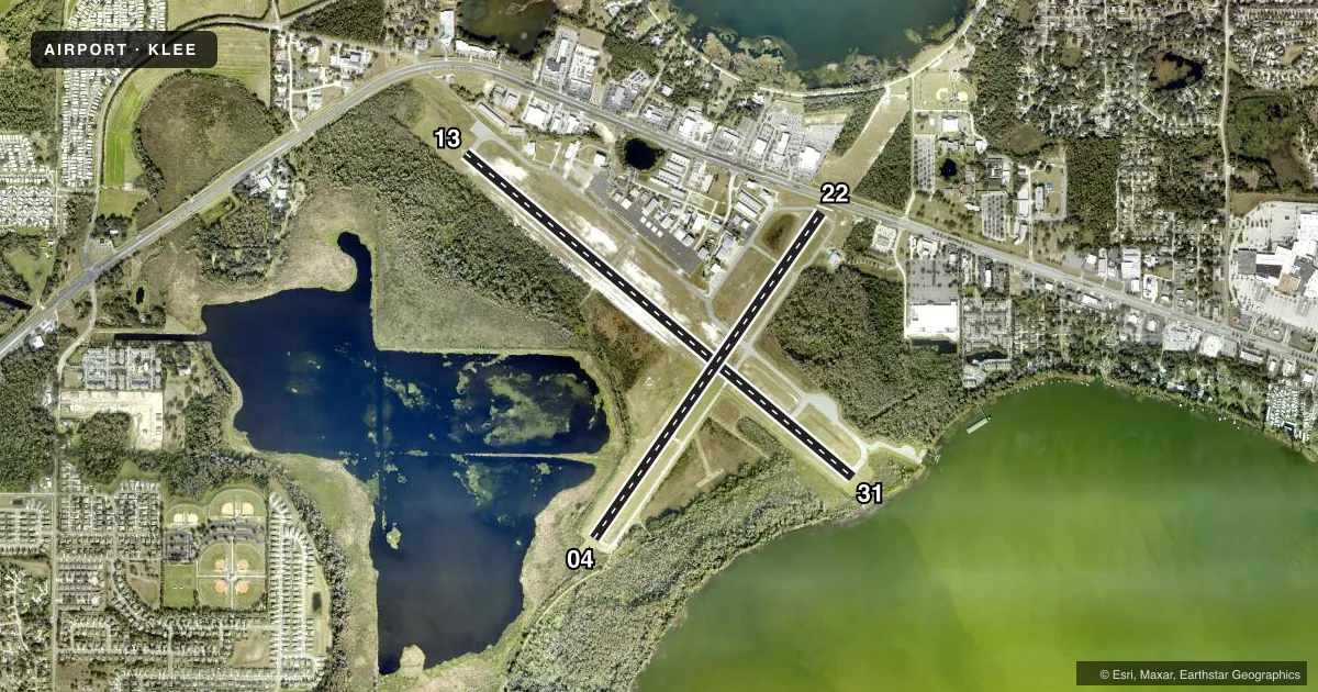
Runways & pattern
Full pagePattern entry · RWY 13
LEFT TRAFFIC| Runway | Heading (°M) | Length | Surface | Traffic |
|---|---|---|---|---|
| 13/31Favored | 125° / 305° | 6,300 ft | ASPH | Standard L |
| 04/22 | 30° / 210° | 4,957 ft | ASPH | Standard L |
Runway end performance
| End | TORA | TODA | ASDA | LDA | VGSI | Approach lights | Obstruction |
|---|---|---|---|---|---|---|---|
| 13 | 6,300' | 6,300' | 5,500' | 5,211' | PAPI 4-box left(3°) | — | 64', trees, 1870' from thr, 250' R of cntrln, slope 26 |
| 31 | 6,300' | 6,300' | 6,000' | 5,600' | PAPI 4-box left(3°) | — | 5', brush, 200' from thr, 170' R of cntrln, slope 0 |
| 04 | 4,957' | 4,957' | 4,688' | 4,688' | PAPI 4-box left(3°) | — | 9', brush, 200' from thr, 80' R of cntrln, slope 0 |
| 22 | 4,957' | 4,957' | 4,957' | 4,647' | PAPI 4-box right(3°) | — | 11', berm, 81' from thr, 0' R of cntrln, slope 0 |
Declared distances in feet. TORA = takeoff run available, TODA = takeoff distance, ASDA = accelerate-stop, LDA = landing distance.
Airport sketch
Runways drawn to scale from FAA survey coordinates, rendered over satellite imagery. Not for navigation.
Approaches & charts
Services on the field
Fuel grades, oxygen, maintenance, ramp storage and lighting — as declared to the FAA by the airport operator.
Fuel & services
- Fuel
- 100LLA
- Oxygen (bottled)
- Low pressure
- Oxygen (bulk)
- Not available
- Airframe repair
- Major
- Power plant repair
- Major
- Other services
- AGRI,AVNCS,CHTR,INSTR,RNTL,SALES
Ramp & ground
- Transient storage
- Tie-down
- Hangar
- Landing fee
- No fee published
- Customs
- Not available
- Lighting schedule
- SEE RMK
- Beacon schedule
- SS-SR
- Beacon
- White / Green (civil land)(WG)
- Wind indicator
- Lighted
Fuel & FBOs
Cheapest 100LL and Jet A on the field and nearby. Always confirm with the FBO before taxi.
Airport notes
Surface conditions, obstructions, local procedures, lighting outages and other notes published with each FAA cycle.
General notes
- BIRD ACT INVOF ARPT.
- UNLGTD 30 FT OBSTNS 440 FT BFR AER RWY 04.
- 24 HR PPR FOR ACFT EQUIPPED WITH WEATHER MODIFICATION OR GEOENGINEERING EQPT 352-516-7236.
Lighting notes
- ACTVT REILS 13 & 31; PAPI RWYS 04, 22, 13 & 31; MIRL RWYS 04/22 & 13/31 - CTAF. TWY LGTS OPR DUSK - 2200; AFT 2200 ACTVT - CTAF.
Fuel notes
- 100LL24 HR SELF SERVE.
Runway surface & condition
- 13/3125 FT PAVED SHOULDERS EACH SIDE. TREES ALG SW SIDE OF RWY IN TRSN SFC.
Approach & departure obstructions
- 0425 FT TREES 235 FT LEFT OF CNTRLN 100 FT FM RWY END.
- 2211 FT BERM FULL WID OF RWY 81 FT FM RWY END.
- 31BRUSH 5 FT TALL 200 FT BEFORE TO 920 FT AFTER AER INSIDE PRI SFC.
- 04TREES 235 FT W OF CNTRLN FOR FIRST 1000 FT INSIDE PRI SFC.
- 04BRUSH/TREES INSIDE PRI SFC 80 FT TO 250 FT L OF CL WITHIN FIRST 700 FT.
- 13APCH SLP 34:1 TO DTHR.
- 22CONTROLLING OBSTN EXCEEDS A 45 DEG SLP. APCH SLP 21:1 TO DTHR.
- 31CONTROLLING OBSTN EXCEEDS A 45 DEG SLP. APCH SLP 20:1 TO DTHR.
Other notes
- EXISTED PRIOR TO 1959.
- MANAGEREXT 1130 OR 352-728-9786.
VFR map & nearby airports
VFR sectional. Tap any ICAO chip to open that airport.
Key facts · KLEE
Answer card- ICAO
- KLEE
- Name
- LEESBURG INTL
- Location
- LEESBURG, FLORIDA
- Elevation
- 76 ft MSL
- Traffic pattern altitude
- 1,076 ft MSL (1,000 AGL)
- Control tower
- Towered · 0700-1900
- Total runways
- 2
- Longest runway
- 13/31 · 6,300 ft
- Published ILS approaches
- 0
- Published frequencies
- 9
- Magnetic variation
- 5°
- Current flight rules
- VFR
- Current wind
- 170° at 8 kt
- Favored runway now
- RWY 13
Leesburg Intl is in Leesburg, Florida. The field elevation is 76 ft MSL. It has two asphalt runways. The longest is runway 13/31 at 6,300 ft. The tower is open 0700-1900. No ILS approaches are published here. Pattern altitude is not published. Use 1,000 ft AGL for light piston traffic unless the current Chart Supplement says otherwise.
Sunair Aviation is on the field. It carries 100LL, Jet A and Jet A Prist. The airport sits in central Florida. Expect busy local traffic and bird activity in the area. Runway lighting is set up for night use, with REIL on 13 and 31. PAPI is installed on all four runway ends. Taxiway lights run from dusk to 2200. After 2200, lighting activation is on CTAF.
There are a few runway-specific items to brief before arrival. Runway 31 has a controlling obstruction on the approach. Runway 04 has brush and trees close to the primary surface. Runway 22 has an 11 ft berm near the departure end. Runways 13 and 31 also have 25 ft paved shoulders. If you are planning a first stop here, check the current Chart Supplement for any noise or operational notes before you go.