METAR & TAF KHND
Current METAR
Observed 11:56Z
KHND 271156Z AUTO 17008KT 10SM CLR 32/08 A2993 RMK AO2 SLP114 T03170078 10356 20317 53003 $
- Wind
- 170° @ 8 kt
- Visibility
- 10 SM
- Temp / Dew
- 32°C / 8°C
- Altimeter
- 29.93 inHg
- Clouds
- CLR
- Density alt
- 5,117 ft
- Ceiling
- Unlimited
- Rules
- VFR
Airport info & contacts
Manager on record, flight service, ARTCC, attendance schedule and pattern altitude — published by the FAA and refreshed every 28 days.
Location
- From city
- 11 NM S
- VFR sectional
- LAS VEGAS
- ARTCC
- ZLA · LOS ANGELES
- NOTAM facility
- HND (NOTAM-D)
Airport manager
- Name
- BRUCE DAUGHERTY
- Phone
- 702-261-4802
- Address
- 3500 EXECUTIVE TERMINAL DRIVE, SUITE 100, HENDERSON NV 89052
Flight service · Hours
- FSS RNO
- RENO1-800-WX-BRIEF
- Attendance
- 0500-2230
Frequencies
Tap any row to copy the frequency to your clipboard.
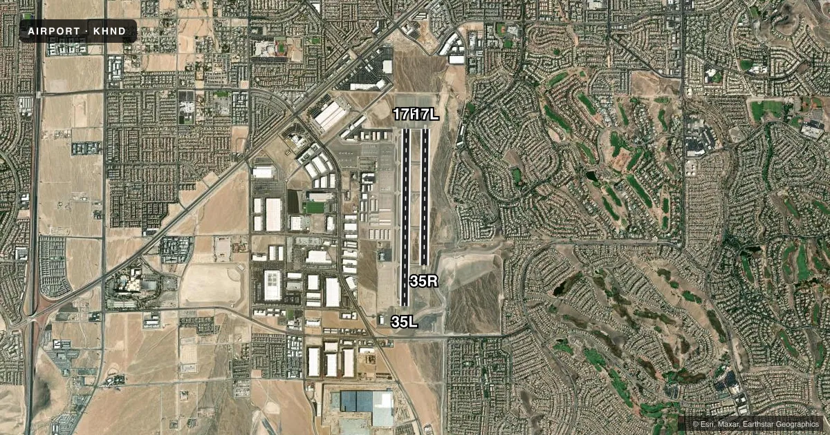
Runways & pattern
Full pagePattern entry · RWY 17R
LEFT TRAFFIC| Runway | Heading (°M) | Length | Surface | Traffic |
|---|---|---|---|---|
| 17R/35LFavored | 168° / 348° | 6,501 ft | ASPH | Standard L |
| 17L/35R | 168° / 348° | 5,001 ft | ASPH | Standard L |
Runway end performance
| End | TORA | TODA | ASDA | LDA | VGSI | Approach lights | Obstruction |
|---|---|---|---|---|---|---|---|
| 17R | — | — | — | — | PAPI 4-box left(3°) | — | — |
| 35L | — | — | — | — | PAPI 4-box left(4.3°) | — | 44', road, 1095' from thr, 0' R of cntrln, slope 20 |
| 17L | — | — | — | — | PAPI 4-box left(3°) | — | — |
| 35R | — | — | — | — | PAPI 4-box left(4.3°) | — | — |
Declared distances in feet. TORA = takeoff run available, TODA = takeoff distance, ASDA = accelerate-stop, LDA = landing distance.
Airport sketch
Runways drawn to scale from FAA survey coordinates, rendered over satellite imagery. Not for navigation.
Approaches & charts
Services on the field
Fuel grades, oxygen, maintenance, ramp storage and lighting — as declared to the FAA by the airport operator.
Fuel & services
- Fuel
- 100LLA
- Oxygen (bulk)
- HIGH/LOW
- Airframe repair
- Minor
- Power plant repair
- Minor
- Other services
- AMB,AVNCS,CHTR,INSTR,RNTL,SALES
Ramp & ground
- Transient storage
- Tie-down
- Landing fee
- No fee published
- Customs
- Not available
- Lighting schedule
- SEE RMK
- Beacon schedule
- SS-SR
- Beacon
- White / Green (civil land)(WG)
- Wind indicator
- Lighted
- Segmented circle
- Yes
Fuel & FBOs
Cheapest 100LL and Jet A on the field and nearby. Always confirm with the FBO before taxi.
Airport notes
Surface conditions, obstructions, local procedures, lighting outages and other notes published with each FAA cycle.
General notes
- COML AIR TOUR TFC ARR FM SE DALGT HR.
- CTN: ACFT DEP RWY 17R OR 35L MUST VFY PSN ON RWY NOT ON PARL TWY.
- FOR CD WHEN ATCT CLSD CTC LAS APCH ON 125.475 OR PH 725-200-4432.
- WHEN SPL EVENT PRKG PPR PROGRAM NOTAM IS ACTV, TSNT ACFT OPERS NOT PERM BASED NEED TO OBTAIN A PPR NR FM AN FBO FOR EA LDG. PPR APPVL & CONFIRMATION NRS CAN BE OBTAINED FM THE SEL FBO AT 702-261-7775. PPR CONFIRMATION NRS SHOULD BE ENTERED IN THE RMKS SECTION OF EACH FLT PLAN.
Lighting notes
- ACTVT REIL RWY 17R & 35L, 17L & 35R; PAPI RWY 17R & 35L, 17L & 35R; MIRL RWY 17R/35L, 17L/35R - CTAF.
Fuel notes
- 100LL100LL SELF-SVC H24.
Runway surface & condition
- 17L/35ROPS DLY 1900-0700.
Approach & departure obstructions
- 35LPAPI UNUSBL BYD 3.3 NM FM RWY THR.
- 35RPAPI UNUSBL BYD 3.5 NM FM RWY THR.
Other notes
- MANAGEROPS: 702-261-4851.
VFR map & nearby airports
VFR sectional. Tap any ICAO chip to open that airport.
Key facts · KHND
Answer card- ICAO
- KHND
- Name
- HENDERSON EXEC
- Location
- LAS VEGAS, NEVADA
- Elevation
- 2,491.4 ft MSL
- Traffic pattern altitude
- 3,491.4 ft MSL (1,000 AGL)
- Control tower
- Towered · 0600-2000
- Total runways
- 2
- Longest runway
- 17R/35L · 6,501 ft
- Published ILS approaches
- 0
- Published frequencies
- 9
- Magnetic variation
- 13°
- Current flight rules
- VFR
- Current wind
- 170° at 8 kt
- Favored runway now
- RWY 17R
Henderson Executive Airport sits in Las Vegas, Nevada. Field elevation is 2,491.4 ft MSL. The airport has two asphalt runways. The longest is 6,501 ft on 17R/35L. The control tower is open from 0600 to 2000. No ILS approaches are published here. Pattern altitude is not published, so use 1,000 ft AGL for light piston operations unless current local guidance says otherwise.
This is a busy Las Vegas area field, so expect a lot of traffic flow and stay sharp on taxi. The published remarks call out a runway safety item on 17R/35L. Verify your position on the runway before takeoff. Do not line up on the parallel taxiway by mistake. Commercial air tour traffic also arrives from the southeast daily at a light hour. That is worth keeping in mind when you are sequencing in the pattern.
Henderson Executive Airport, the on-field FBO, carries 100LL, Jet A and Jet A Prist. 100LL self-serve fuel is available 24 hours a day. Runway lighting is installed on both runways. PAPI and runway end identifier lights are also published. If the tower is closed, contact Las Vegas Approach on 125.475 for clearance delivery. Check the current FAA Chart Supplement for any special event prior permission required notices before you go.