METAR & TAF KHHR
Current METAR
Observed 12:53Z
KHHR 271253Z AUTO 14004KT 9SM BKN008 21/19 A2993 RMK AO2 SLP132 T02110189
- Wind
- 140° @ 4 kt
- Visibility
- 9 SM
- Temp / Dew
- 21°C / 19°C
- Altimeter
- 29.93 inHg
- Clouds
- BKN
- Density alt
- 789 ft
- Ceiling
- 800 ft AGL
- Rules
- IFR
Airport info & contacts
Manager on record, flight service, ARTCC, attendance schedule and pattern altitude — published by the FAA and refreshed every 28 days.
Location
- From city
- 1 NM E
- VFR sectional
- LOS ANGELES
- Pattern altitude
- 1,100 ft AGL · 1,166 ft MSL
- ARTCC
- ZLA · LOS ANGELES
- NOTAM facility
- HHR (NOTAM-D)
Airport manager
- Name
- GUIDO FERNANDEZ
- Phone
- 310-349-1637
- Address
- 12101 S.CRENSHAW BLVD, SUITE # 3, HAWTHORNE CA 90250
Flight service · Hours
- FSS HHR
- HAWTHORNE1-800-WX-BRIEF
- Attendance
- M-F · 0600-2200
- SAT · 0600-2200
- SUN · 0600-2200
Frequencies
Tap any row to copy the frequency to your clipboard.
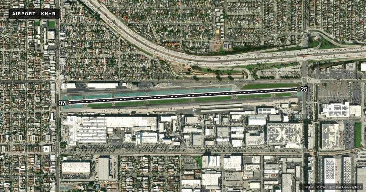
Runways & pattern
Full pagePattern entry · RWY 07
RIGHT TRAFFICRunway end performance
| End | TORA | TODA | ASDA | LDA | VGSI | Approach lights | Obstruction |
|---|---|---|---|---|---|---|---|
| 07 | 4,884' | 4,884' | 4,667' | 3,762' | VASI 2-box right(3.25°) | — | 13', road, 200' from thr, 0' R of cntrln, slope 0 |
| 25 | 4,884' | 4,884' | 4,654' | 4,194' | VASI 4-box right(3.5°) | ODALS | 23', pole, 200' from thr, 100' R of cntrln, slope 0 |
Declared distances in feet. TORA = takeoff run available, TODA = takeoff distance, ASDA = accelerate-stop, LDA = landing distance.
Airport sketch
Runways drawn to scale from FAA survey coordinates, rendered over satellite imagery. Not for navigation.
Approaches & charts
ILS · 1
Services on the field
Fuel grades, oxygen, maintenance, ramp storage and lighting — as declared to the FAA by the airport operator.
Fuel & services
- Fuel
- 100LLA
- Oxygen (bottled)
- High pressure
- Oxygen (bulk)
- High pressure
- Airframe repair
- Major
- Power plant repair
- Major
- Other services
- AVNCS,INSTR,RNTL,SALES
Ramp & ground
- Transient storage
- Tie-down
- Landing fee
- No fee published
- Customs
- Not available
- Lighting schedule
- SEE RMK
- Beacon schedule
- SS-SR
- Beacon
- White / Green (civil land)(WG)
- Wind indicator
- Lighted
- Segmented circle
- Yes
Fuel & FBOs
Cheapest 100LL and Jet A on the field and nearby. Always confirm with the FBO before taxi.
Airport notes
Surface conditions, obstructions, local procedures, lighting outages and other notes published with each FAA cycle.
General notes
- <OBSTN PT 77: HNGRS, PLINES, BLDG-ANT ON RWY 07; POLES & TRML ON RWY 25.
- BE ALERT TO 8 FT BLAST FENCE AER 25.
- (E81) N EDGE OF N TWY UNLGTD; WEST 1000' OF SOUTH TWY UNLGTD.
- NUMEROUS FLOCKS OF BIRDS ON AND INVOF ARPT.
- TGL, STOP AND GO LDG AND LOW APCH OPNS FOR ALL ACFT INCLG HELS LTD TO 1000-1700 DLY.
- NO PAT OPNS, NO TAXI-BACK OPNS MON-FRI 2200-0800, SAT-SUN 2200-1000.
- RWY 25 RUNUP SOUTH OF S TWY 900 FT WEST OF AER 25.
- N TWY WEST OF E TWY DESIGNATED NON-MOVEMENT AREA.
- FOR NOISE ABATEMENT INFO CTC ARPT SUPVR (310) 349-1637 OR 1636.
- NO FRMN TKOFS AUTH.
- RWY 25 TOUCH AND GO, STOP AND GO, AND INT TKOFS ARE REQSTD TO BE AIRBORNE BY D TWY.
- HOVER WORK LTD TO N TWY BTN C AND D TWYS.
- ALL PISTON ACFT MUST BE EQUIPPED WITH MUFFLER SYS.
- FOR CD WHEN ATCT CLSD CTC SOCAL APCH AT 800-448-3724.
- NO FLD COND NOTAMS AVBL 2100-0500.
Lighting notes
- WHEN ATCT CLSD ACTVT MIRL RY 07/25 & ODALS RY 25 - CTAF.
Fuel notes
- 100LL100LL FUEL AVBL 24 HRS SELF-SERVICE. JET A FUEL AVBL 0500-2200 M-F, 0600-2100 SAT, 0600-2200 SUN; AFTER HRS SVC CALL JET CENTER LOS ANGELES (310) 676-4673 OR HAWTHORNE HANGAR OPERATIONS (310) 644-0400.
Approach & departure obstructions
- 07LOC AT RY END. STREET AT 110 FT FROM RY END 07 +37 FT POLE 100 FT FROM E OR 250 FT RIGHT; +10 FT BLDG 100 FT FROM E OR 200 FT RIGHT.
- 25+8 FT BLAST FENCE LEFT AT 70 FT ON CNTRLN; +23 FT LGT STD AT 110 FT; STREET AT 110 FT FM RY END 25; 500 FT LEFT & RIGHT OF CNTRLN; +6 FT FENCE LEFT AT 105 FT FM EOR 500 FT LEFT & RIGHT OF CNTRLN.
- 07APCH RATIO 50:1 TO DSPLCD THR; APCH RATIO TO DSPLCD THR OVER +12 FT HGR -L 0 FT FROM DSPLCD THR 225 FT LEFT 0:1.
- 25APCH RATIO 28:1 TO DSPLCD THLD; APCH RATIO TO DSPLCD THLD OVER +15 FT ROAD 0 FT FM DSPLCD THLD 150 FT RIGHT 0:1.
Other notes
- TPA FOR TURBINE & HIGH PER ACFT 1600 (1534), LGT ACFT 1100 (1034), HELS 700 (634).
- MANAGEREMAIL: GFERNANDEZ@CITYOFHAWTHORNE.ORG
VFR map & nearby airports
VFR sectional. Tap any ICAO chip to open that airport.
Key facts · KHHR
Answer card- ICAO
- KHHR
- Name
- JACK NORTHROP FLD/HAWTHORNE MUNI
- Location
- HAWTHORNE, CALIFORNIA
- Elevation
- 65.9 ft MSL
- Traffic pattern altitude
- 1,165.9 ft MSL (1,100 AGL)
- Control tower
- Towered · 0600-2200
- Total runways
- 1
- Longest runway
- 07/25 · 4,884 ft
- Published ILS approaches
- 1
- Published frequencies
- 16
- Magnetic variation
- 14°
- Current flight rules
- IFR
- Current wind
- 140° at 4 kt
- Favored runway now
- RWY 07
Jack Northrop Fld/Hawthorne Muni is in Hawthorne, California. The field elevation is 65.9 ft MSL. KHHR has one runway, 07/25, which is 4,884 ft long. The tower is open daily from 0600 to 2200. There is one ILS approach. It serves runway 25.
Pattern altitude is 1,100 ft AGL, which is 1,165.9 ft MSL. ARCHER is the on-field FBO. It carries AVGAS 100LL, Jet A and Jet A Prist. Hawthorne sits in a busy metro area. Expect traffic flow discipline to matter. The published remarks also call out bird activity in and around the airport. That is worth keeping in mind on arrival and departure.
There are a few operational items to brief before you go. Touch-and-go, stop-and-go and low approach work are limited to 1000 to 1700 daily. No pattern operations or taxi-back operations are permitted Monday through Friday from 2200 to 0800. The same restriction applies Saturday through Sunday from 2200 to 1000. Piston aircraft must have a muffler system. The runway environment also has several nearby obstructions. Use the current Chart Supplement and the airport operator if you need the latest detail before a first visit.