METAR & TAF KHDC
Current METAR
Observed 11:55Z
KHDC 271155Z AUTO 00000KT 10SM CLR 25/25 A3000 RMK AO2 T02510247 10275 20250
- Wind
- 000° @ 0 kt
- Visibility
- 10 SM
- Temp / Dew
- 25°C / 25°C
- Altimeter
- 30.00 inHg
- Clouds
- CLR
- Density alt
- 1,158 ft
- Ceiling
- Unlimited
- Rules
- VFR
Airport info & contacts
Manager on record, flight service, ARTCC, attendance schedule and pattern altitude — published by the FAA and refreshed every 28 days.
Location
- From city
- 3 NM NE
- VFR sectional
- NEW ORLEANS
- Pattern altitude
- 956 ft AGL · 1,002 ft MSL
- ARTCC
- ZHU · HOUSTON
- NOTAM facility
- DRI (NOTAM-D)
Airport manager
- Name
- TONY MICHELLI
- Phone
- 985-277-5667
- Address
- 600 JUDGE LEON FORD DRIVE, HAMMOND LA 70401
Flight service · Hours
- FSS DRI
- DE RIDDER1-800-WX-BRIEF
- Attendance
- MON-FRI · 0600-2000
- SAT-SUN · 0800-1800
Frequencies
Tap any row to copy the frequency to your clipboard.
Runways & pattern
Full pagePattern entry · RWY 13
LEFT TRAFFIC| Runway | Heading (°M) | Length | Surface | Traffic |
|---|---|---|---|---|
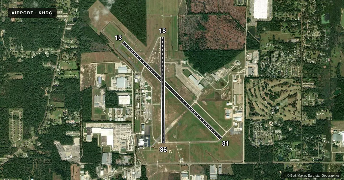
| 13/31 | 135° / 315° | 6,502 ft | ASPH-CONC | Standard L |
| 18/36 | 180° / 0° | 5,001 ft | CONC | Standard L |
Runway end performance
| End | TORA | TODA | ASDA | LDA | VGSI | Approach lights | Obstruction |
|---|---|---|---|---|---|---|---|
| 13 | — | — | — | — | PAPI 4-box left(3.3°) | — | — |
| 31 | — | — | — | — | PAPI 4-box left(3.3°) | — | 91', trees, 1700' from thr, 0' R of cntrln, slope 17 |
| 18 | — | — | — | — | PAPI 4-box left(3°) | MALSR | — |
| 36 | — | — | — | — | PAPI 4-box left(3°) | — | — |
Declared distances in feet. TORA = takeoff run available, TODA = takeoff distance, ASDA = accelerate-stop, LDA = landing distance.
Airport sketch
Runways drawn to scale from FAA survey coordinates, rendered over satellite imagery. Not for navigation.
Approaches & charts
ILS · 1
Services on the field
Fuel grades, oxygen, maintenance, ramp storage and lighting — as declared to the FAA by the airport operator.
Fuel & services
- Fuel
- 100LLA
- Oxygen (bottled)
- Not available
- Oxygen (bulk)
- Not available
- Airframe repair
- Major
- Power plant repair
- Major
- Other services
- AMB,CHTR,INSTR,RNTL
Ramp & ground
- Transient storage
- Tie-down
- Hangar
- Landing fee
- No fee published
- Customs
- Not available
- Lighting schedule
- SEE RMK
- Beacon schedule
- SS-SR
- Beacon
- White / Green (civil land)(WG)
- Wind indicator
- Lighted
- Segmented circle
- No
Fuel & FBOs
Cheapest 100LL and Jet A on the field and nearby. Always confirm with the FBO before taxi.
Airport notes
Surface conditions, obstructions, local procedures, lighting outages and other notes published with each FAA cycle.
General notes
- BIRDS, DEER & COYOTES ON & INVOF ARPT.
- MIL & GOVT ACFT SVCD AT NW APN AT FBO.
- FOR CD WHEN ATCT IS CLSD CTC MSY APCH AT 504-471-4350 OR 119.3.
- CAUTION: TWY D UNMKD AND UNLGTD.
- PILOTS CONDUCTING EFVS OPS; BE AWARE LED ALS IN USE RWY 18.
- CTC APRT MGR FOR DSGND RAMP SPACE FOR PUB USE.
Lighting notes
- ACTVT MALSR RWY 18; REIL RWY 13, 31, & 36; MIRL RWY 13/31 & 18/36; PRESET LOW INTST DUSK-DAWN; TO INCR INTST - CTAF.
Approach & departure obstructions
- 31RWY 31 RIGHT SIDE REIL OTS.
- 31APCH SLOPE 26:1 TO DSPLCD THLD.
VFR map & nearby airports
VFR sectional. Tap any ICAO chip to open that airport.
Key facts · KHDC
Answer card- ICAO
- KHDC
- Name
- HAMMOND NORTHSHORE RGNL
- Location
- HAMMOND, LOUISIANA
- Elevation
- 46.1 ft MSL
- Traffic pattern altitude
- 1,002.1 ft MSL (956 AGL)
- Control tower
- Towered · 0800-1600
- Total runways
- 2
- Longest runway
- 13/31 · 6,502 ft
- Published ILS approaches
- 1
- Published frequencies
- 8
- Magnetic variation
- 0°
- Current flight rules
- VFR
- Current wind
- 000° at 0 kt
- Favored runway now
- –
Hammond Northshore Rgnl Airport sits in Hammond, Louisiana. Field elevation is 46.1 ft MSL. The airport has two runways. The longest is runway 13/31 at 6,502 ft. Runway 18/36 is 5,001 ft. The tower is open from 0800 to 1800. When the tower is closed, clearance delivery is handled through New Orleans Approach on 119.3 or by phone at 504-471-4350.
There is one ILS approach. It serves runway 18. Pattern altitude is 956 ft AGL, which is 1,002.1 ft MSL. Runway 18 has MALSR lighting. REIL is available on runways 13, 31 and 36. Runway 31 right side REIL is out of service. Lighting is preset to low intensity from dusk to dawn. Use CTAF if you need higher intensity.
On field FBOs are Pierce Aviation, Top Gun Hammond and SKY X Aviation. Pierce carries 100LL and Jet A Prist. Top Gun carries 100LL, Jet A and Jet A Prist. SKY X carries 100LL. Taxiway D is unmarked and unlighted, so taxi with care. The field also notes birds, deer and coyotes in the area. Military and government aircraft are serviced at the northwest apron at the FBO. If you need ramp space for public use, contact the airport manager before arrival.