METAR & TAF KGFL
Current METAR
Observed 17:53Z
KGFL 271753Z AUTO 21008KT 10SM SCT050 SCT060 29/17 A2977 RMK AO2 SLP077 T02940172 10294 20206 56018
- Wind
- 210° @ 8 kt
- Visibility
- 10 SM
- Temp / Dew
- 29°C / 17°C
- Altimeter
- 29.77 inHg
- Clouds
- SCT
- Density alt
- 2,273 ft
- Ceiling
- Unlimited
- Rules
- VFR
Airport info & contacts
Manager on record, flight service, ARTCC, attendance schedule and pattern altitude — published by the FAA and refreshed every 28 days.
Location
- From city
- 3 NM NE
- VFR sectional
- NEW YORK
- ARTCC
- ZBW · BOSTON
- NOTAM facility
- GFL (NOTAM-D)
Airport manager
- Name
- ROBIN MAPP
- Phone
- 518-792-5995
- Address
- 443 QUEENSBURY AVE, RM 201, QUEENSBURY NY 12804
Flight service · Hours
- FSS BTV
- BURLINGTON1-800-WX-BRIEF
- Attendance
- 0800-1800
Frequencies
Tap any row to copy the frequency to your clipboard.
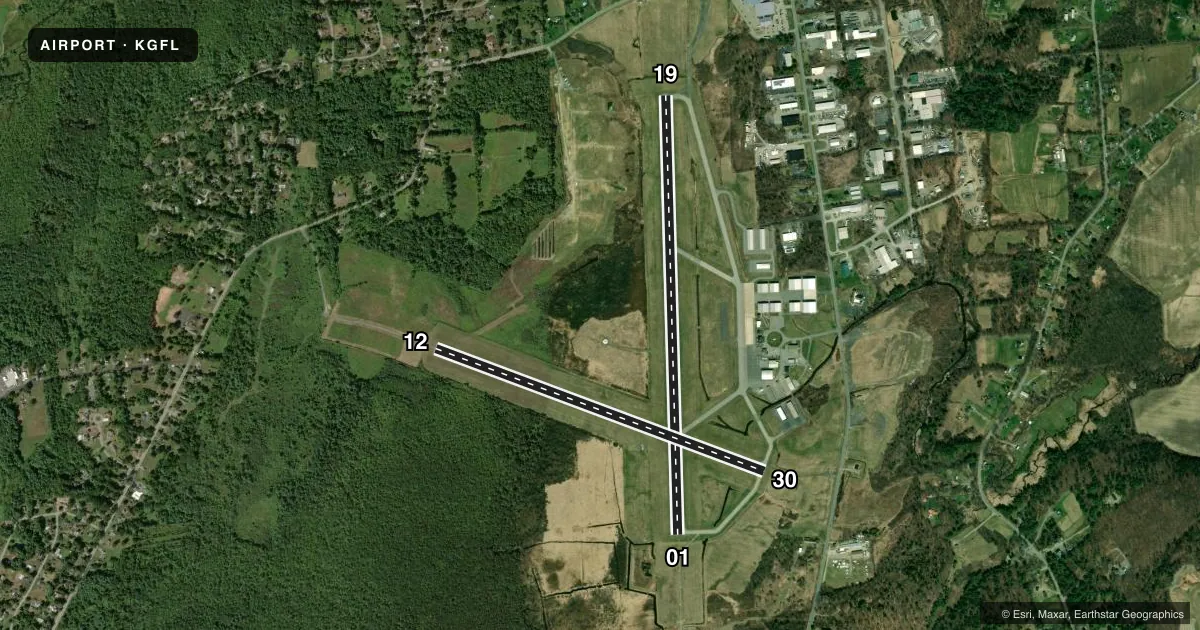
Runways & pattern
Full pagePattern entry · RWY 19
LEFT TRAFFIC| Runway | Heading (°M) | Length | Surface | Traffic |
|---|---|---|---|---|
| 01/19Favored | 344° / 164° | 5,000 ft | ASPH | Standard L |
| 12/30 | 96° / 276° | 3,999 ft | ASPH | Standard L |
Runway end performance
| End | TORA | TODA | ASDA | LDA | VGSI | Approach lights | Obstruction |
|---|---|---|---|---|---|---|---|
| 01 | 5,000' | 5,000' | 5,000' | 5,000' | PAPI 4-box left(3°) | MALSR | — |
| 19 | 5,000' | 5,000' | 5,000' | 5,000' | PAPI 4-box left(3.5°) | — | 57', trees, 1715' from thr, 315' R of cntrln, slope 26 |
| 12 | 3,999' | 3,999' | 3,999' | 3,999' | PAPI 4-box left(3.85°) | — | 147', trees, 2885' from thr, 567' R of cntrln, slope 19 |
| 30 | 3,999' | 3,999' | 3,999' | 3,999' | PAPI 4-box left(3°) | — | 71', trees, 1870' from thr, 0' R of cntrln, slope 23 |
Declared distances in feet. TORA = takeoff run available, TODA = takeoff distance, ASDA = accelerate-stop, LDA = landing distance.
Airport sketch
Runways drawn to scale from FAA survey coordinates, rendered over satellite imagery. Not for navigation.
Approaches & charts
ILS · 1
Services on the field
Fuel grades, oxygen, maintenance, ramp storage and lighting — as declared to the FAA by the airport operator.
Fuel & services
- Fuel
- 100LLA
- Oxygen (bottled)
- Not available
- Oxygen (bulk)
- Not available
- Airframe repair
- Major
- Power plant repair
- Major
- Other services
- CARGO,CHTR,INSTR,RNTL,SALES
Ramp & ground
- Transient storage
- Tie-down
- Hangar
- Landing fee
- No fee published
- Customs
- Not available
- Lighting schedule
- SEE RMK
- Beacon schedule
- SS-SR
- Beacon
- White / Green (civil land)(WG)
- Wind indicator
- Lighted
Fuel & FBOs
Cheapest 100LL and Jet A on the field and nearby. Always confirm with the FBO before taxi.
Airport notes
Surface conditions, obstructions, local procedures, lighting outages and other notes published with each FAA cycle.
General notes
- RWYS12 & 19 APCHS OBSCURED FM ONE ANOTHER DUE TO HIGH GND.
- FOUR OBSTN LGT POLES 1-1/2 MI TO 1-3/4 MI N OF RWY 19.
- BIRDS/DEER ON & INVOF ARPT.
- RWY 01 DSGND CALM WIND RWY.
- GRASS CUTTING EQPT OPS ADJACENT TO ALL OPERATIONAL SFCS DALGT HRS MAY THRU OCT.
- ULTRA-LIGHT ACT ON & INVOF ARPT.
- ULTRA-LIGHT ACFT USE 500 FT AGL LEFT TFC FOR ALL RWYS.
- DRG PDS OF SNOW REMOVAL OPNS NOV 1-APR 1 ACFT MUST CTC ARPT ON FREQ 123.0 10 MINS PRIOR TO LDG.
- RSCD MAY NOT BE MONITORED OR REPORTED WHEN THE ARPT IS UNATNDD.
- PJE AIRSPACE DEFINED AS 5 NM RADIUS OF GFL.
- COLD TEMPERATURE AIRPORT. ALTITUDE CORRECTION REQUIRED AT OR BELOW -18C.
- FOR AFT HRS ACFT MAINT ASSISTANCE CALL 518-798-3091.
- NOISE SENSITIVE AREA 1.5 MILES NORTH.
- USE NBAA NOISE ABATEMENT PROCEDURES.
- RCMD NO TOUCH AND GO OPS FM 2200Z-1200Z.
- FOR CD CTC ALBANY APCH AT 518-862-2299.
Lighting notes
- ACTVT MALSR RWY 01; PAPI RWY 01, 19, 12, 30; HIRL RWY 01/19; MIRL RWY 12/30; TWY LGTS - CTAF.
Fuel notes
- 100LLSELF-SERVICE 100LL FUEL AVBL. FULL SERVICE FUELING AVBL AFTER HRS BY PRE-ARRANGEMENT; CALL 518-798-3091.
Runway surface & condition
- 01/19PCR VALUE: 635/F/B/X/T
- 12/30PCR VALUE: 436/F/B/X/T
Other notes
- PPR 48 HRS FOR ACFT OPS WITH MORE THAN 30 PAX SEATS CALL AMGR 518-792-5995.
VFR map & nearby airports
VFR sectional. Tap any ICAO chip to open that airport.
Key facts · KGFL
Answer card- ICAO
- KGFL
- Name
- FLOYD BENNETT MEML
- Location
- GLENS FALLS, NEW YORK
- Elevation
- 328.4 ft MSL
- Traffic pattern altitude
- 1,328.4 ft MSL (1,000 AGL)
- Control tower
- Non-towered (use CTAF)
- Total runways
- 2
- Longest runway
- 01/19 · 5,000 ft
- Published ILS approaches
- 1
- Published frequencies
- 4
- Magnetic variation
- 14°
- Current flight rules
- VFR
- Current wind
- 210° at 8 kt
- Favored runway now
- RWY 19
Floyd Bennett Memorial Airport (KGFL) is in Glens Falls, New York. Field elevation is 328.4 ft MSL. The airport has two asphalt runways. The longest is runway 01/19 at 5,000 ft. Runway 12/30 is 3,999 ft. There is no control tower, so expect CTAF and UNICOM self-announce traffic. The published ILS is for runway 01. Pattern altitude is not published. Use the standard 1,000 ft AGL for light piston traffic unless the current Chart Supplement says otherwise.
Rich Air is on the field. It carries 100LL and Jet A. For after-hours aircraft maintenance help, the published number is the same one listed for Rich Air. The airport remarks call out birds and deer in the area. Ultralight activity is also noted on and near the field. There is a noise sensitive area 1.5 miles north. Use NBAA noise abatement procedures. Touch-and-go work is recommended to be avoided from 2200Z to 1200Z. Runway 12 and runway 19 approaches are obscured from one another by high ground, so plan your traffic flow with that in mind.
This is an uncontrolled airport with published approach frequencies through Albany Approach. Clearance delivery is also handled through Albany Approach. The field sits in a terrain-influenced area, so brief your arrival and departure paths carefully. Check the current FAA Chart Supplement before you go.