METAR & TAF KGEU
Current METAR
Observed 12:47Z
KGEU 271247Z 22011KT 10SM CLR 33/17 A2983 RMK FIRST
- Wind
- 220° @ 11 kt
- Visibility
- 10 SM
- Temp / Dew
- 33°C / 17°C
- Altimeter
- 29.83 inHg
- Clouds
- CLR
- Density alt
- 3,600 ft
- Ceiling
- Unlimited
- Rules
- VFR
Airport info & contacts
Manager on record, flight service, ARTCC, attendance schedule and pattern altitude — published by the FAA and refreshed every 28 days.
Location
- From city
- 6 NM W
- VFR sectional
- PHOENIX
- Pattern altitude
- 1,030 ft AGL · 2,101 ft MSL
- ARTCC
- ZAB · ALBUQUERQUE
- NOTAM facility
- GEU (NOTAM-D)
Airport manager
- Name
- MATTHEW SMITH
- Phone
- 623-930-2188
- Address
- 6801 N. GLEN HARBOR BLVD, SUITE 201, GLENDALE AZ 85307
Flight service · Hours
- FSS PRC
- PRESCOTT1-800-WX-BRIEF
- Attendance
- 0630-1930
Frequencies
Tap any row to copy the frequency to your clipboard.
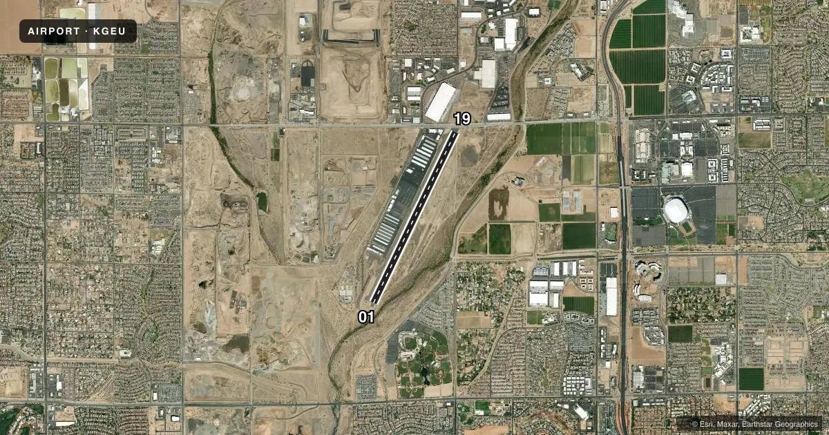
Runways & pattern
Full pagePattern entry · RWY 19
LEFT TRAFFICRunway end performance
| End | TORA | TODA | ASDA | LDA | VGSI | Approach lights | Obstruction |
|---|---|---|---|---|---|---|---|
| 01 | 7,150' | 7,150' | 6,980' | 6,279' | PAPI 2-box left(3°) | — | 13', road, 201' from thr, 150' R of cntrln, slope 0 |
| 19 | 7,150' | 7,150' | 7,116' | 6,115' | PAPI 2-box left(3°) | — | 6', fence, 201' from thr, 150' R of cntrln, slope 0 |
Declared distances in feet. TORA = takeoff run available, TODA = takeoff distance, ASDA = accelerate-stop, LDA = landing distance.
Airport sketch
Runways drawn to scale from FAA survey coordinates, rendered over satellite imagery. Not for navigation.
Approaches & charts
Services on the field
Fuel grades, oxygen, maintenance, ramp storage and lighting — as declared to the FAA by the airport operator.
Fuel & services
- Fuel
- 100LLA1+
- Oxygen (bottled)
- Low pressure
- Airframe repair
- Major
- Power plant repair
- Major
- Other services
- AVNCS,CHTR,INSTR,RNTL
Ramp & ground
- Transient storage
- Tie-down
- Lighting schedule
- SEE RMK
- Beacon schedule
- SS-SR
- Beacon
- White / Green (civil land)(WG)
- Wind indicator
- Lighted
- Segmented circle
- Yes
Fuel & FBOs
Cheapest 100LL and Jet A on the field and nearby. Always confirm with the FBO before taxi.
Airport notes
Surface conditions, obstructions, local procedures, lighting outages and other notes published with each FAA cycle.
General notes
- MIL JET TFC 5 MI W. COYOTES & BIRDS ON & INVOF ARPT.
- UNMKD & UNLGT PWR LINES 1/4 MI W PARL TO RWY.
- TGL DISCOURAGED BTN 2200-0600.
- AVOID NOISE SENSITIVE AREA N & SE; NOISE ABATEMENT PROC - AMGR.
- HEL PAT WEST NA SS-SR.
- FOR CD WHEN ATCT CLSD, CTC PHOENIX APCH AT 602-306-2565.
Lighting notes
- WHEN ATCT CLSD ACTVT REIL RWY 01 & 19; PAPI RWY 01 & 19; MIRL RWY 01/19 - 121.00.
Fuel notes
- 100LLSELF SERV AVBL H24.
- A1+JET A 0630-1930; FEE AFT HR - 623-877-3333.
Approach & departure obstructions
- 01+13 FT ROAD 0-200 FT FM RWY END 150 FT R.
- 19+12 FT BLAST FENCE 95 FT FM RWY END BOTH SIDES.
- 01PREFERRED FOR NOISE ABATEMENT.
- 01+13 FT ROAD 135 FT FM DTHR 275 FT R; APCH SLOPE 10:1 AT DTHR.
- 19+14 FT ROAD 470 FT FM DTHR 310 FT L; APCH SLOPE 33:1 AT DTHR.
Other notes
- THIS AIRPORT HAS BEEN SURVEYED BY THE NATIONAL GEODETIC SURVEY.
- PROVIDED INGRESS/EGRESS ROUTES SHOULD BE LTD SO AS TO BE COMPATIBLE WITH THE FIXED WING OPERATIONS ON THE ARPT RWYS.
- TPA HIGH PERFORMANCE 1530 FT AGL, HELICOPTER/ULTRALIGHTS 630 FT AGL.
- MANAGER623-930-2188 FM 0800-1700; 602-980-0433 FM 0600-2000.
VFR map & nearby airports
VFR sectional. Tap any ICAO chip to open that airport.
Key facts · KGEU
Answer card- ICAO
- KGEU
- Name
- GLENDALE RGNL
- Location
- GLENDALE, ARIZONA
- Elevation
- 1,071.3 ft MSL
- Traffic pattern altitude
- 2,101.3 ft MSL (1,030 AGL)
- Control tower
- Towered · 0600-2030 MON-FRI; 0700-1900 SAT & SUN
- Total runways
- 1
- Longest runway
- 01/19 · 7,150 ft
- Published ILS approaches
- 0
- Published frequencies
- 9
- Magnetic variation
- 12°
- Current flight rules
- VFR
- Current wind
- 220° at 11 kt
- Favored runway now
- RWY 19
Glendale Rgnl sits in Glendale, Arizona at 1,071.3 ft MSL. It has one runway, 01/19, which is 7,150 ft long. The airport is towered. Tower hours are 0600-2030 Monday through Friday. Weekend hours are 0700-1900. There are no published ILS approaches here. Plan with the current chart and your own approach setup if you are coming in IFR.
Pattern altitude is 1,030 ft AGL, which is 2,101.3 ft MSL. Glendale Aero Services is on the field. It carries 100LL and Jet A Prist. Self-serve 100LL is available 24 hours a day. Jet A fuel is available from 0630 to 1930. After-hours fuel use has a fee, so call ahead if you expect to arrive late.
This is a busy metro-area airport. Noise-sensitive areas lie north and southeast of the field. Runway 01 is preferred for noise abatement. Military jet traffic is 5 miles west. Coyotes and birds are reported on and near the airport. Runway 01 has road and threshold obstruction notes in the published remarks, so brief yourself on the current Chart Supplement before arrival. When the tower is closed, use 121.00 to activate the runway lights, REILs and PAPI for runways 01 and 19. Helicopter pattern west is not authorized from sunset to sunrise.