METAR & TAF KEVV
Current METAR
Observed 12:54Z
KEVV 271254Z 22005KT 10SM CLR 24/21 A2991 RMK AO2 SLP124 T02390206 $
- Wind
- 220° @ 5 kt
- Visibility
- 10 SM
- Temp / Dew
- 24°C / 21°C
- Altimeter
- 29.91 inHg
- Clouds
- CLR
- Density alt
- 1,615 ft
- Ceiling
- Unlimited
- Rules
- VFR
Airport info & contacts
Manager on record, flight service, ARTCC, attendance schedule and pattern altitude — published by the FAA and refreshed every 28 days.
Location
- From city
- 3 NM N
- VFR sectional
- ST LOUIS
- ARTCC
- ZID · INDIANAPOLIS
- NOTAM facility
- EVV (NOTAM-D)
Airport manager
- Name
- NATE HAHN
- Phone
- 812-421-4401
- Address
- 7801 BUSSING DR, EVANSVILLE IN 47725-6799
Flight service · Hours
- FSS HUF
- TERRE HAUTE1-800-WX-BRIEF
- Attendance
- ALL
Frequencies
Tap any row to copy the frequency to your clipboard.
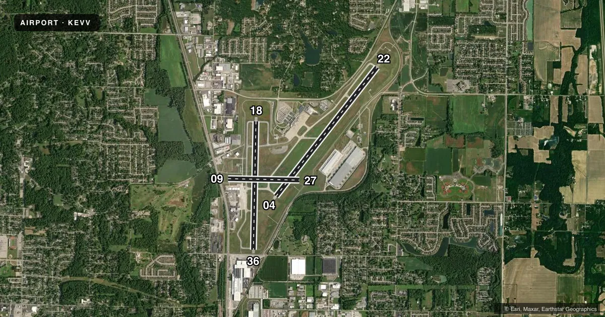
Runways & pattern
Full pagePattern entry · RWY 22
LEFT TRAFFIC| Runway | Heading (°M) | Length | Surface | Traffic |
|---|---|---|---|---|
| 04/22Favored | 35° / 215° | 8,021 ft | ASPH | Standard L |
| 18/36 | 178° / 358° | 6,286 ft | ASPH | Standard L |
| 09/27 | 88° / 268° | 3,497 ft | ASPH | Standard L |
Runway end performance
| End | TORA | TODA | ASDA | LDA | VGSI | Approach lights | Obstruction |
|---|---|---|---|---|---|---|---|
| 04 | 8,021' | 8,021' | 8,021' | 8,021' | PAPI 4-box right(3°) | — | 119', tree, 5713' from thr, 12' R of cntrln, slope 47 |
| 22 | 8,021' | 8,021' | 8,021' | 8,021' | — | MALSR | 43', pole, 2843' from thr, 808' R of cntrln, slope 50 |
| 18 | 5,498' | 5,498' | 5,498' | 5,498' | PAPI 4-box right(3°) | — | 64', pole, 1430' from thr, 120' R of cntrln, slope 19 |
| 36 | 6,287' | 6,287' | 6,287' | 5,498' | PAPI 4-box left(3°) | — | 15', road, 277' from thr, 10' R of cntrln, slope 5 |
| 09 | 3,497' | 3,497' | 3,497' | 2,968' | — | — | 14', road, 375' from thr, 250' R of cntrln, slope 12 |
| 27 | 3,497' | 3,497' | 3,497' | 3,279' | — | — | 17', road, 268' from thr, 0' R of cntrln, slope 4 |
Declared distances in feet. TORA = takeoff run available, TODA = takeoff distance, ASDA = accelerate-stop, LDA = landing distance.
Airport sketch
Runways drawn to scale from FAA survey coordinates, rendered over satellite imagery. Not for navigation.
Approaches & charts
ILS · 2
Services on the field
Fuel grades, oxygen, maintenance, ramp storage and lighting — as declared to the FAA by the airport operator.
Fuel & services
- Fuel
- 100LLA
- Oxygen (bottled)
- High pressure
- Airframe repair
- Major
- Power plant repair
- Major
- Other services
- AFRT,AVNCS,CHTR,INSTR,RNTL,SALES
Ramp & ground
- Transient storage
- Tie-down
- Hangar
- Landing fee
- No fee published
- Customs
- Not available
- Lighting schedule
- SEE RMK
- Beacon schedule
- SS-SR
- Beacon
- White / Green (civil land)(WG)
- Wind indicator
- Lighted
- Segmented circle
- No
Fuel & FBOs
Cheapest 100LL and Jet A on the field and nearby. Always confirm with the FBO before taxi.
Airport notes
Surface conditions, obstructions, local procedures, lighting outages and other notes published with each FAA cycle.
General notes
- BIRDS ON & INVOF ARPT.
- TWY E LGTS OTS.
- FOR CD WHEN ATCT CLSD CTC INDIANAPOLIS ARTCC AT 317-247-2411.
- RWY 09/27 & TWY E RSTRD TO LESS THAN 50000 LB.
Lighting notes
- ACTVT MALSR RWY 22; REIL RWY 4, 18 & 36; PAPI RWY 4; MIRL RWY 9/27; HIRL RWY 18/36 - CTAF. WHEN ATCT CLSD HIRL RWY 4/22 PRESET LOW INTS; INCR INTS - CTAF.
Runway surface & condition
- 04/22PCR VALUE: 660/F/B/X/T
- 18/36PCR VALUE: 1049/F/B/X/T
Approach & departure obstructions
- 09APCH RATIO 20:1 AT DTHR; 60 FT TREES 1400 FT FM THR 250 FT L.
- 27APCH RATIO 26:1 AT DTHR; 18 FT ROAD 475 FT FM THR 13 FT L.
- 36APCH RATIO 25:1 AT DTHR; 51 FT LGTD BLDG 1296 FT FM THR 308 FT L; APCH RATIO 50:1 AT DTHR OVR ROAD.
Other notes
- INDEX C ARFF AVBL O/R - 812-421-4408.
VFR map & nearby airports
VFR sectional. Tap any ICAO chip to open that airport.
Key facts · KEVV
Answer card- ICAO
- KEVV
- Name
- EVANSVILLE RGNL
- Location
- EVANSVILLE, INDIANA
- Elevation
- 421.7 ft MSL
- Traffic pattern altitude
- 1,421.7 ft MSL (1,000 AGL)
- Control tower
- Towered · 0600-2300
- Total runways
- 3
- Longest runway
- 04/22 · 8,021 ft
- Published ILS approaches
- 2
- Published frequencies
- 17
- Magnetic variation
- 3°
- Current flight rules
- VFR
- Current wind
- 220° at 5 kt
- Favored runway now
- RWY 22
Evansville Rgnl sits in Evansville, Indiana. Field elevation is 421.7 ft MSL. The airport has 3 asphalt runways. The longest is 8,021 ft on 04/22. The tower is open daily from 0600 to 2300. Two ILS approaches are published for runway ends 04 and 22.
Pattern altitude is not published in the facts. Use the standard 1,000 ft AGL pattern for light piston traffic unless ATC or the current FAA Chart Supplement says otherwise. United Companies Air Center is on the field. It carries 100LL and Jet A Prist. Call ahead at (812) 426-1221 for current service details.
This is a busy controlled field with Class C service on the published approach and departure frequency. Taxiway E lights are out of service. Birds are reported on and near the airport. Runway 09/27 and taxiway E are restricted to less than 50,000 pounds. Runway 22 has MALSR lighting. Runway 4 has PAPI. Runways 18 and 36 have high intensity lights that operate on CTAF. If the tower is closed, the runway 4 and 22 lights start at low intensity. Use CTAF to increase them. If you need clearance delivery after tower hours, contact Indianapolis ARTCC.