METAR & TAF KEMT
Current METAR
Observed 02:45Z
KEMT 270245Z 22007KT 10SM CLR 29/18 A2989
- Wind
- 220° @ 7 kt
- Visibility
- 10 SM
- Temp / Dew
- 29°C / 18°C
- Altimeter
- 29.89 inHg
- Clouds
- CLR
- Density alt
- 2,084 ft
- Ceiling
- Unlimited
- Rules
- VFR
Airport info & contacts
Manager on record, flight service, ARTCC, attendance schedule and pattern altitude — published by the FAA and refreshed every 28 days.
Location
- From city
- 1 NM N
- VFR sectional
- LOS ANGELES
- ARTCC
- ZLA · LOS ANGELES
- NOTAM facility
- EMT (NOTAM-D)
Airport manager
- Name
- SALVADOR EULLOQUI BOBADILLA
- Phone
- 626-776-4370
- Address
- 4233 SANTA ANITA AVE, EL MONTE CA 91731
Flight service · Hours
- FSS RAL
- RIVERSIDE1-800-WX-BRIEF
- Attendance
- ALL
Frequencies
Tap any row to copy the frequency to your clipboard.
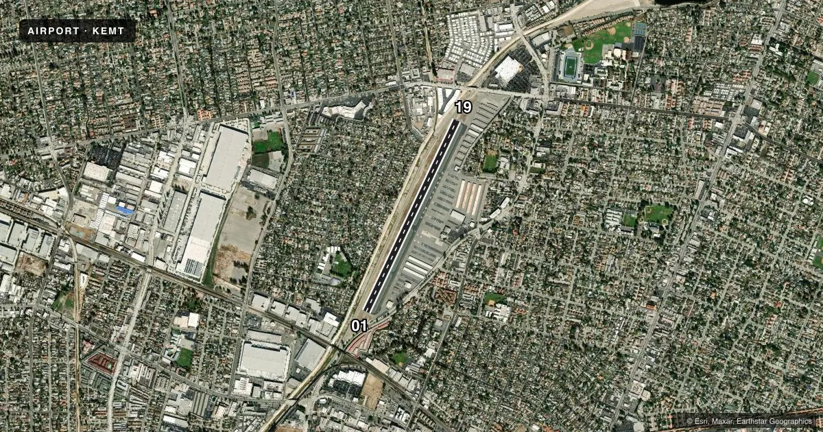
Runways & pattern
Full pagePattern entry · RWY 19
RIGHT TRAFFICRunway end performance
| End | TORA | TODA | ASDA | LDA | VGSI | Approach lights | Obstruction |
|---|---|---|---|---|---|---|---|
| 01 | 3,504' | 3,995' | 3,755' | 3,465' | PAPI 2-box left(4.57°) | — | 18', pole, 350' from thr, 85' R of cntrln, slope 8 |
| 19 | 3,995' | 3,995' | 3,995' | 3,354' | PAPI 2-box right(4.5°) | — | 30', pole, 800' from thr, 205' R of cntrln, slope 20 |
Declared distances in feet. TORA = takeoff run available, TODA = takeoff distance, ASDA = accelerate-stop, LDA = landing distance.
Airport sketch
Runways drawn to scale from FAA survey coordinates, rendered over satellite imagery. Not for navigation.
Approaches & charts
Services on the field
Fuel grades, oxygen, maintenance, ramp storage and lighting — as declared to the FAA by the airport operator.
Fuel & services
- Fuel
- 100LLA
- Oxygen (bulk)
- Not available
- Airframe repair
- Major
- Power plant repair
- Major
- Other services
- AVNCS,CHTR,INSTR,RNTL,SALES,SURV
Ramp & ground
- Transient storage
- Tie-down
- Landing fee
- No fee published
- Customs
- Not available
- Lighting schedule
- SEE RMK
- Beacon schedule
- SS-SR
- Beacon
- White / Green (civil land)(WG)
- Wind indicator
- Lighted
- Segmented circle
- Yes
Fuel & FBOs
Cheapest 100LL and Jet A on the field and nearby. Always confirm with the FBO before taxi.
Airport notes
Surface conditions, obstructions, local procedures, lighting outages and other notes published with each FAA cycle.
General notes
- REMAIN OVER PAVED CHANNEL ON CLIMB OUT TO SOUTH AND TO NORTH.
- HEAVY BIRD ACTIVITY ON & INVOF ARPT.
- LGTD WATER TWR 1 MI W-SW OF ARPT.
- (E81) CNTR TWY LGTS ONLY.
- NOISE ABATEMENT PROCEDURES IN EFFECT, CTC ARPT MANAGER FOR DETAILS.
- FOR CLNC DEL WHEN ATCT CLSD CALL SOCAL APP (800) 448-3724.
Lighting notes
- WHEN ATCT CLSD ACTVT REIL RWY 19, MIRL RWY 01/19 - CTAF.
Approach & departure obstructions
- 01RWY 01 +6 FT FENCE 120 FT R OF CNTRLN; +6 FT FENCE 120 FT LEFT & PARALLEL TO CNTRLN 0-200 FT FM END OF RY.
- 19+2 FT FENCE 75 FT RIGHT OF CNTRLN AT THR TO 0 FT RIGHT OF CNTRLN AT 200 FT.
- 01APCH RATIO 35:1 TO DSPLCD THR; APCH RATIO 33:1 TO DSPLCD THR OVER +45' PLINE OB 1490' FM DSPLCD THR.
- 19APCH RATIO 48:1 TO DSPLCD THR.
Other notes
- THIS AIRPORT HAS BEEN SURVEYED BY THE NATIONAL GEODETIC SURVEY.
- OWNERLA COUNTY CTC: PAUL MASELBAS, 626-300-4600 X4615.
VFR map & nearby airports
VFR sectional. Tap any ICAO chip to open that airport.
Key facts · KEMT
Answer card- ICAO
- KEMT
- Name
- SAN GABRIEL VALLEY
- Location
- EL MONTE, CALIFORNIA
- Elevation
- 295.6 ft MSL
- Traffic pattern altitude
- 1,295.6 ft MSL (1,000 AGL)
- Control tower
- Towered · 0800-2000
- Total runways
- 1
- Longest runway
- 01/19 · 3,995 ft
- Published ILS approaches
- 0
- Published frequencies
- 11
- Magnetic variation
- 14°
- Current flight rules
- VFR
- Current wind
- 220° at 7 kt
- Favored runway now
- RWY 19
San Gabriel Valley Airport is in El Monte, California. Field elevation is 295.6 ft MSL. The airport has one runway, 01/19, which is 3,995 ft long and paved. The control tower is open 0800 to 2000. No ILS approaches are published here. Pattern altitude is not published, so use the standard 1,000 ft AGL for light piston traffic unless the current Chart Supplement says otherwise.
Billion Air Aviation is on the field. It carries 100LL, Jet A and Jet A Prist. If you need fuel or ramp details, call them directly at (626) 208-3708. The airport sits under SoCal Class C procedures. Check the current chart for the exact airspace picture before you go.
A few local items matter on a first visit. Noise abatement procedures are in effect. Contact the airport manager for details. There is heavy bird activity on and near the airport. Remain over the paved channel on climb out to the south. Remain over the paved channel on climb out to the north. Runway 01 has fence obstructions near the departure end. Runway 19 has a fence near the threshold. When the tower is closed, use CTAF to activate the runway end identifier lights on runway 19. Use CTAF to activate the medium intensity runway lights for runway 01/19. There is also a lighted water tower about 1 mile west-southwest of the field.