METAR & TAF KECP
Current METAR
Observed 15:53Z
KECP 271553Z 33011G16KT 10SM CLR 33/25 A2993 RMK AO2 SLP145 T03280250
- Wind
- 330° @ 11G16 kt
- Visibility
- 10 SM
- Temp / Dew
- 33°C / 25°C
- Altimeter
- 29.93 inHg
- Clouds
- CLR
- Density alt
- 2,233 ft
- Ceiling
- Unlimited
- Rules
- VFR
Airport info & contacts
Manager on record, flight service, ARTCC, attendance schedule and pattern altitude — published by the FAA and refreshed every 28 days.
Location
- From city
- 16 NM NW
- VFR sectional
- NEW ORLEANS
- ARTCC
- ZJX · JACKSONVILLE
- NOTAM facility
- ECP (NOTAM-D)
Airport manager
- Name
- PARKER MCCLELLAN
- Phone
- 850-763-6751
- Address
- 6300 WEST BAY PARKWAY, PANAMA CITY BEACH FL 32409
Flight service · Hours
- FSS GNV
- GAINESVILLE1-800-WX-BRIEF
- Attendance
- ALL
Frequencies
Tap any row to copy the frequency to your clipboard.
Runways & pattern
Full pagePattern entry · RWY 34
LEFT TRAFFICRunway end performance
| End | TORA | TODA | ASDA | LDA | VGSI | Approach lights | Obstruction |
|---|---|---|---|---|---|---|---|
| 16 | — | — | — | — | PAPI 4-box left(3°) | MALSR | 39', trees, 2180' from thr, 310' R of cntrln, slope 50 |
| 34 | — | — | — | — | PAPI 4-box left(3°) | — | 61', trees, 2660' from thr, 595' R of cntrln, slope 40 |
Declared distances in feet. TORA = takeoff run available, TODA = takeoff distance, ASDA = accelerate-stop, LDA = landing distance.
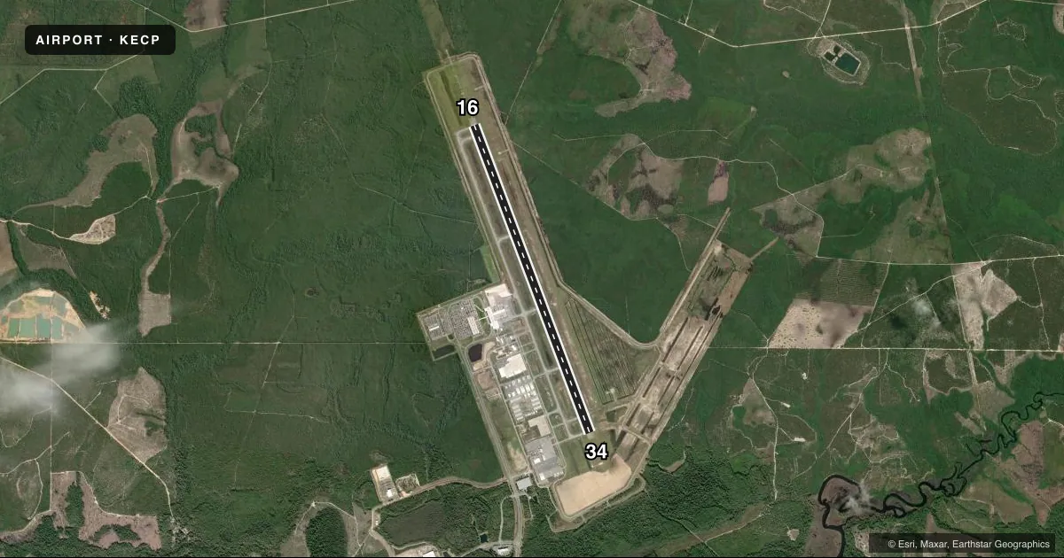
Airport sketch
Runways drawn to scale from FAA survey coordinates, rendered over satellite imagery. Not for navigation.
Approaches & charts
ILS · 1
Services on the field
Fuel grades, oxygen, maintenance, ramp storage and lighting — as declared to the FAA by the airport operator.
Fuel & services
- Fuel
- 100LLA
- Oxygen (bottled)
- Not available
- Oxygen (bulk)
- Not available
- Other services
- INSTR,RNTL
Ramp & ground
- Transient storage
- Tie-down
- Hangar
- Lighting schedule
- SEE RMK
- Beacon schedule
- SS-SR
- Beacon
- White / Green (civil land)(WG)
- Wind indicator
- Lighted
- Segmented circle
- Yes
Fuel & FBOs
Cheapest 100LL and Jet A on the field and nearby. Always confirm with the FBO before taxi.
Airport notes
Surface conditions, obstructions, local procedures, lighting outages and other notes published with each FAA cycle.
General notes
- MIL VIP ARR/DEP SHALL BE AT ARPT TERM WITH PRIOR APVL FM ARPT AUTH - 850-763-6751 EXT 306.
- TWY J BTN TWY D & TAXILANE F CLSD TO ACFT WITH WINGSPAN GTR THAN 80 FT EXC 1 HR PPR - 850-769-6033. TWY K, M, E2, E3 BTN TWY D & TAXILANE F RSTRD TO ACFT WITH WINGSPAN GTR THAN 80 FT.
- BIRDS ON & INVOF ARPT.
Lighting notes
- WHEN ATCT CLSD ACTVT MALSR RWY 16; REIL RWY 34; TDZ RWY 16; CNTLN RWY 16/34; PAPI RWY 16 & 34; HIRL RWY 16/34 - CTAF.
Runway surface & condition
- 16/34PCR VALUE: 690/R/B/W/T
VFR map & nearby airports
VFR sectional. Tap any ICAO chip to open that airport.
Key facts · KECP
Answer card- ICAO
- KECP
- Name
- NORTHWEST FLORIDA BEACHES INTL
- Location
- PANAMA CITY, FLORIDA
- Elevation
- 68.8 ft MSL
- Traffic pattern altitude
- 1,068.8 ft MSL (1,000 AGL)
- Control tower
- Towered · 0600-2200
- Total runways
- 1
- Longest runway
- 16/34 · 10,000 ft
- Published ILS approaches
- 1
- Published frequencies
- 7
- Magnetic variation
- 3°
- Current flight rules
- VFR
- Current wind
- 330° at 11 kt
- Favored runway now
- RWY 34
Northwest Florida Beaches Intl is in Panama City, Florida. Field elevation is 68.8 ft MSL. The airport has one runway, 16/34, which is 10,000 ft long and paved with concrete. The control tower is open daily from 0600 to 2200. There is one ILS approach. It serves runway 16. Pattern altitude is not published, so plan on the standard 1,000 ft AGL for light piston traffic unless the current Chart Supplement says otherwise.
The on-field FBOs are Sheltair and Southern Sky Aviation. Both carry 100LL, Jet A and Jet A Prist. If you need fuel or ramp details, call them directly before arrival. Published remarks also note bird activity on and near the airport. Keep a sharp scan on climbout and final. Taxiway restrictions apply to aircraft with wingspans over 80 feet on parts of the field. Military VIP arrivals and departures need prior approval. When the tower is closed, runway 16 and 34 lighting can be activated on CTAF. That matters for night arrivals.
For a first-time visit, the main things to plan for are the towered environment, the single long runway and the published lighting setup after hours. Check the current FAA Chart Supplement for any updated procedures before you go.