METAR & TAF KDVN
Current METAR
Observed 12:52Z
KDVN 271252Z AUTO 16005KT 9SM CLR 27/26 A2981 RMK AO2 SLP084 T02720256 $
- Wind
- 160° @ 5 kt
- Visibility
- 9 SM
- Temp / Dew
- 27°C / 26°C
- Altimeter
- 29.81 inHg
- Clouds
- CLR
- Density alt
- 2,507 ft
- Ceiling
- Unlimited
- Rules
- VFR
Airport info & contacts
Manager on record, flight service, ARTCC, attendance schedule and pattern altitude — published by the FAA and refreshed every 28 days.
Location
- From city
- 5 NM N
- VFR sectional
- CHICAGO
- ARTCC
- ZAU · CHICAGO
- NOTAM facility
- DVN (NOTAM-D)
Airport manager
- Name
- JACOB SACHLEBEN
- Phone
- 563-391-5650
- Address
- 9230 HARRISON STREET, DAVENPORT IA 52806
Flight service · Hours
- FSS FOD
- FORT DODGE1-800-WX-BRIEF
- Attendance
- 0630-DUSK
Frequencies
Tap any row to copy the frequency to your clipboard.
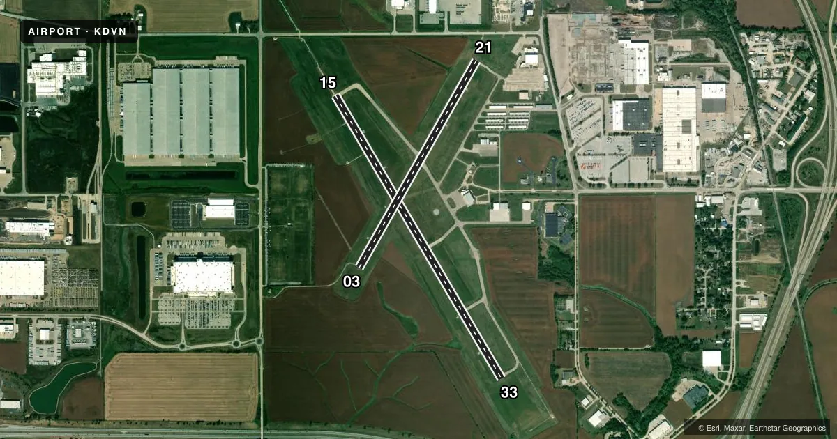
Runways & pattern
Full pagePattern entry · RWY 15
LEFT TRAFFIC| Runway | Heading (°M) | Length | Surface | Traffic |
|---|---|---|---|---|
| 15/33Favored | 149° / 329° | 5,511 ft | CONC | Standard L |
| 03/21 | 29° / 209° | 4,001 ft | CONC | Standard L |
Runway end performance
| End | TORA | TODA | ASDA | LDA | VGSI | Approach lights | Obstruction |
|---|---|---|---|---|---|---|---|
| 15 | — | — | — | — | VASI 4-box left(3°) | MALSR | 19', road, 1180' from thr, 0' R of cntrln, slope 50 |
| 33 | — | — | — | — | VASI 4-box left(3°) | — | — |
| 03 | — | — | — | — | VASI 4-box left(3°) | — | — |
| 21 | — | — | — | — | VASI 4-box left(3°) | — | 14', road, 375' from thr, 250' R of cntrln, slope 12 |
Declared distances in feet. TORA = takeoff run available, TODA = takeoff distance, ASDA = accelerate-stop, LDA = landing distance.
Airport sketch
Runways drawn to scale from FAA survey coordinates, rendered over satellite imagery. Not for navigation.
Approaches & charts
ILS · 1
Services on the field
Fuel grades, oxygen, maintenance, ramp storage and lighting — as declared to the FAA by the airport operator.
Fuel & services
- Fuel
- 100LLA
- Oxygen (bottled)
- Not available
- Oxygen (bulk)
- Not available
- Airframe repair
- Major
- Power plant repair
- Major
- Other services
- CHTR,INSTR,RNTL,SALES
Ramp & ground
- Transient storage
- Tie-down
- Hangar
- Landing fee
- No fee published
- Customs
- Not available
- Lighting schedule
- SEE RMK
- Beacon schedule
- SS-SR
- Beacon
- White / Green (civil land)(WG)
- Wind indicator
- Lighted
- Segmented circle
- No
Fuel & FBOs
Cheapest 100LL and Jet A on the field and nearby. Always confirm with the FBO before taxi.
Airport notes
Surface conditions, obstructions, local procedures, lighting outages and other notes published with each FAA cycle.
General notes
- HELICOPTER OPERATIONS ON CTAF OPERG PARALLEL TO RYS FM GRASS AREAS.
- RWY 15 DESIGNATED CALM WIND RY.
- TWO WAY RADIO COMMUNICATIONS REQUIRED FOR ALL ACFT CONDUCTING MULTIPLE OPNS.
- EXTSV HVY MIL HEL (CHINOOK) TRNG ON & INVOF OF ARPT; PSBL EXTREME TRUB FM ROTORS.
- ARNG: DSN 431-5510.
- PAEW ANG RAMP LIMITED PARKING 48 HR PPR.
- JET A AND 100LL FULL SVC AVBL ON MAIN RAMP IN FRONT OF TRML BUILDING.
- 100LL SELF SVC FUEL AVBL ON E END OF TWY C.
- FOR CD CTC CHICAGO ARTCC AT 630-906-8921.
- CAUTION WILDLIFE INVOF
Lighting notes
- DUSK-DAWN. ACTVT MIRL RY 03/21 AND HIRL RY 15/33; VASI RYS 03/21 AND 15/33; MALSR RY 15 & REIL RWYS 3/21 AND 33 - CTAF.
Other notes
- 1FOR SVC AFT HRS CALL (563) 391-5650.
- MANAGERJACOB SACHLEBEN , OPERATIONS MANAGER 563-391-5650
VFR map & nearby airports
VFR sectional. Tap any ICAO chip to open that airport.
Key facts · KDVN
Answer card- ICAO
- KDVN
- Name
- DAVENPORT MUNI
- Location
- DAVENPORT, IOWA
- Elevation
- 750.5 ft MSL
- Traffic pattern altitude
- 1,750.5 ft MSL (1,000 AGL)
- Control tower
- Non-towered (use CTAF)
- Total runways
- 2
- Longest runway
- 15/33 · 5,511 ft
- Published ILS approaches
- 1
- Published frequencies
- 5
- Magnetic variation
- 1°
- Current flight rules
- VFR
- Current wind
- 160° at 5 kt
- Favored runway now
- RWY 15
Davenport Muni sits in Davenport, Iowa. Field elevation is 750.5 ft MSL. The airport has 2 concrete runways. The longest is 5,511 ft on runway 15/33. There is no control tower. Pattern altitude is not published, so use the standard 1,000 ft AGL for light piston traffic unless ATC or the current Chart Supplement says otherwise.
Runway 15 has an ILS approach. That is the only published ILS here. The field has a calm wind runway of 15. Runway 15/33 is the longer runway, so it is the one to think about first when wind and performance matter. Runway lighting is pilot controlled on CTAF from dusk to dawn. The airport also has visual approach slope indicators on both runways. Helicopter traffic can be active on CTAF from grass areas. The published remarks also call out heavy Chinook training in and near the airport. Expect possible rotor turbulence. Wildlife is also a known caution here.
Jet Air, Inc. is on the field. It carries 100LL and Jet A. Self-serve 100LL is available on the east end of taxiway C. Full-service Jet A and 100LL are available on the main ramp in front of the terminal. For a first visit, pay close attention to the CTAF traffic picture and the helicopter activity. Two-way radio communications are required for aircraft conducting multiple operations.