METAR & TAF KCRG
Current METAR
Observed 19:53Z
KCRG 271953Z 08007KT 10SM CLR 33/24 A2983 RMK AO2 SLP102 T03330244
- Wind
- 080° @ 7 kt
- Visibility
- 10 SM
- Temp / Dew
- 33°C / 24°C
- Altimeter
- 29.83 inHg
- Clouds
- CLR
- Density alt
- 2,322 ft
- Ceiling
- Unlimited
- Rules
- VFR
Airport info & contacts
Manager on record, flight service, ARTCC, attendance schedule and pattern altitude — published by the FAA and refreshed every 28 days.
Location
- From city
- 8 NM E
- VFR sectional
- JACKSONVILLE
- ARTCC
- ZJX · JACKSONVILLE
- NOTAM facility
- CRG (NOTAM-D)
Airport manager
- Name
- ROLF RIECHMANN
- Phone
- 904-741-5066
- Address
- 855-1 SAINT JOHNS BLUFF RD NORTH, SUITE 500, JACKSONVILLE FL 32225-8388
Flight service · Hours
- FSS GNV
- GAINESVILLE1-800-WX-BRIEF
- Attendance
- MON-FRI · 0600-2300
- SAT-SUN · 0700-2200
Frequencies
Tap any row to copy the frequency to your clipboard.
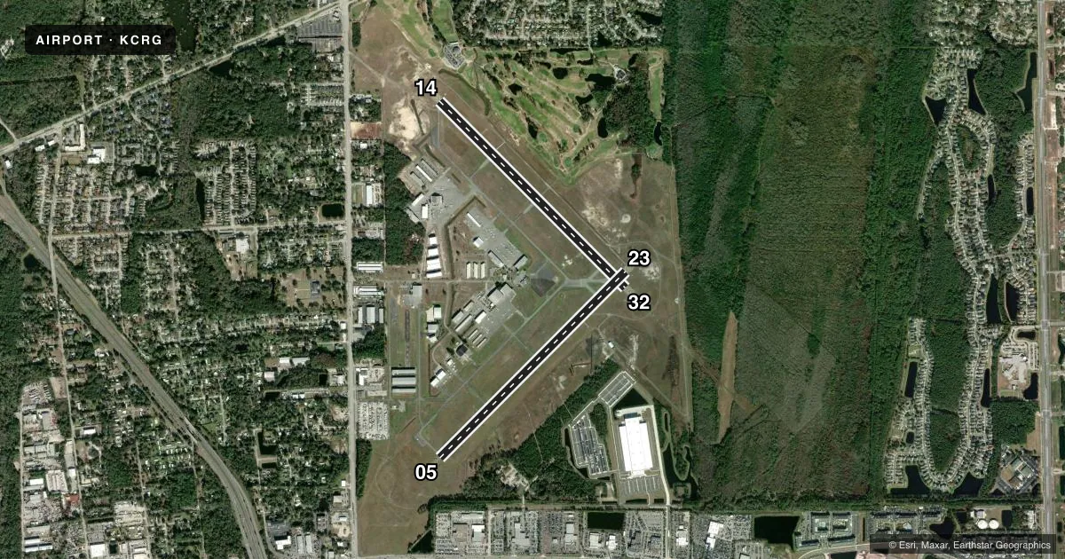
Runways & pattern
Full pagePattern entry · RWY 05
LEFT TRAFFIC| Runway | Heading (°M) | Length | Surface | Traffic |
|---|---|---|---|---|
| 14/32 | 129° / 309° | 4,008 ft | ASPH | Standard L |
| 05/23Favored | 39° / 219° | 4,004 ft | ASPH | Standard L |
Runway end performance
| End | TORA | TODA | ASDA | LDA | VGSI | Approach lights | Obstruction |
|---|---|---|---|---|---|---|---|
| 14 | — | — | — | — | PAPI 4-box left(3°) | — | 61', trees, 2465' from thr, 290' R of cntrln, slope 37 |
| 32 | — | — | — | — | PAPI 4-box left(3°) | MALSR | 20', brush, 1200' from thr, 220' R of cntrln, slope 50 |
| 05 | — | — | — | — | PAPI 4-box left(3°) | — | 114', tower, 3030' from thr, 250' R of cntrln, slope 25 |
| 23 | — | — | — | — | PAPI 4-box left(3°) | — | 36', trees, 975' from thr, 240' R of cntrln, slope 21 |
Declared distances in feet. TORA = takeoff run available, TODA = takeoff distance, ASDA = accelerate-stop, LDA = landing distance.
Airport sketch
Runways drawn to scale from FAA survey coordinates, rendered over satellite imagery. Not for navigation.
Approaches & charts
ILS · 1
Services on the field
Fuel grades, oxygen, maintenance, ramp storage and lighting — as declared to the FAA by the airport operator.
Fuel & services
- Fuel
- 100LLA
- Oxygen (bottled)
- Not available
- Airframe repair
- Major
- Power plant repair
- Major
- Other services
- AMB,AVNCS,CHTR,INSTR,RNTL,SALES,SURV
Ramp & ground
- Transient storage
- Tie-down
- Hangar
- Landing fee
- No fee published
- Customs
- Not available
- Lighting schedule
- SEE RMK
- Beacon schedule
- SS-SR
- Beacon
- White / Green (civil land)(WG)
- Wind indicator
- Lighted
- Segmented circle
- Yes
Fuel & FBOs
Cheapest 100LL and Jet A on the field and nearby. Always confirm with the FBO before taxi.
Airport notes
Surface conditions, obstructions, local procedures, lighting outages and other notes published with each FAA cycle.
General notes
- BIRDS PERIODICALLY ON OR NEAR THE ARPT INCREASING IN ACTIVITY DURING INCLEMENT WEATHER.
- BANNER TOWING ON WEEKENDS & SPECIAL EVENTS.
- VFR NOISE ABATEMENT PROCEDURES IN EFFECT, CALL AMGR 904-641-7666. WX PERMITTING, RY 05 PREFERRED FOR APCH, RY 32 PREFERRED FOR DEP.
- WILDLIFE ON & INVOF ARPT.
- PAVEMENT ACCOMMODATES DESIGN GROUP II ACFT (UP TO 79 FT WINGSPAN) UP TO 60,000 LBS DUAL WHEEL LOADING. PPR FOR ACFT EXCEEDING THESE LTDS CTC AT 904-741-2020.
- 24 HR ADVN NOTICE OR IMT REPORTING UPON LDG FOR ACFT EQUIPPED WITH WEATHER MODIFICATION OR GEOENGINEERING EQUIP CTC ARPT OPS 904-741-2020.
Lighting notes
- WHEN ATCT CLSD ACTVT MALSR RWY 32; REIL RWY 14 & 23; HIRL RWY 14/32, MIRL RWY 5/23 - CTAF.
Runway surface & condition
- 05/23RWY 05/23 HAS 150 FT STWYS BOTH ENDS.
- 14/32RWY 14/32 HAS 150 FT STWYS BOTH ENDS.
Approach & departure obstructions
- 05UNUSBL BYD 3.5 MILES ON FINAL DUE TO LRG TWRS LCTD ON EXTDD CNTRLN.
- 23UNUSBL BYD 8.0 DEGS LEFT AND RIGHT OF CNTRLN.
Other notes
- MANAGERNOISE ABATEMENT COMPLAINTS 904-641-3606.
VFR map & nearby airports
VFR sectional. Tap any ICAO chip to open that airport.
Key facts · KCRG
Answer card- ICAO
- KCRG
- Name
- JACKSONVILLE EXEC AT CRAIG
- Location
- JACKSONVILLE, FLORIDA
- Elevation
- 40.7 ft MSL
- Traffic pattern altitude
- 1,040.7 ft MSL (1,000 AGL)
- Control tower
- Towered · 0600-2300 MON-FRI; 0700-2200 SAT-SUN
- Total runways
- 2
- Longest runway
- 14/32 · 4,008 ft
- Published ILS approaches
- 1
- Published frequencies
- 13
- Magnetic variation
- 6°
- Current flight rules
- VFR
- Current wind
- 080° at 7 kt
- Favored runway now
- RWY 05
Jacksonville Exec at Craig is in Jacksonville, Florida. Field elevation is 40.7 ft MSL. The airport has two asphalt runways. The longest is runway 14/32 at 4,008 ft. Runway 05/23 is 4,004 ft. The tower is open 0600-2300 Monday through Friday. Weekend hours are 0700-2200. One ILS is published for runway 32. Pattern altitude is not published, so use 1,000 ft AGL for light piston traffic unless the current Chart Supplement says otherwise.
Sky Harbor Aviation is on the field. It carries 100LL, Jet A and Jet A Prist. JAX Executive Jet Center is also on the field. It carries 100LL and Jet A. This is a busy Jacksonville airport with VFR noise abatement in effect. Weather permitting, runway 05 is preferred for approach. Runway 32 is preferred for departure. Wildlife is a factor here. Birds and other wildlife are reported on and near the airport. More activity is reported in bad weather. Banner towing also occurs on weekends and special events.
When the tower is closed, lighting is activated by CTAF. Runway 32 uses MALSR. Runways 14 and 23 use REIL. Runway 14/32 has HIRL. Runway 05/23 has MIRL. Runway 23 is unusable beyond 8 degrees left and right of centerline. Runway 05 is unusable beyond 3.5 miles on final because of large towers on the extended centerline. Check the current Chart Supplement for any noise or curfew restrictions before flying in.