METAR & TAF KCGF
Current METAR
Observed 17:45Z
KCGF 271745Z 26010KT 10SM BKN025 28/22 A2983
- Wind
- 260° @ 10 kt
- Visibility
- 10 SM
- Temp / Dew
- 28°C / 22°C
- Altimeter
- 29.83 inHg
- Clouds
- BKN
- Density alt
- 2,758 ft
- Ceiling
- 2,500 ft AGL
- Rules
- MVFR
Airport info & contacts
Manager on record, flight service, ARTCC, attendance schedule and pattern altitude — published by the FAA and refreshed every 28 days.
Location
- From city
- 10 NM E
- VFR sectional
- DETROIT
- ARTCC
- ZOB · CLEVELAND
- NOTAM facility
- CGF (NOTAM-D)
Airport manager
- Name
- J MYERS
- Phone
- 216-289-4111
- Address
- 26300 CURTISS WRIGHT PKWY, RICHMOND HEIGHTS OH 44143-4408
Flight service · Hours
- FSS CLE
- CLEVELAND1-800-WX-BRIEF
- Attendance
- 0600-2300
Frequencies
Tap any row to copy the frequency to your clipboard.
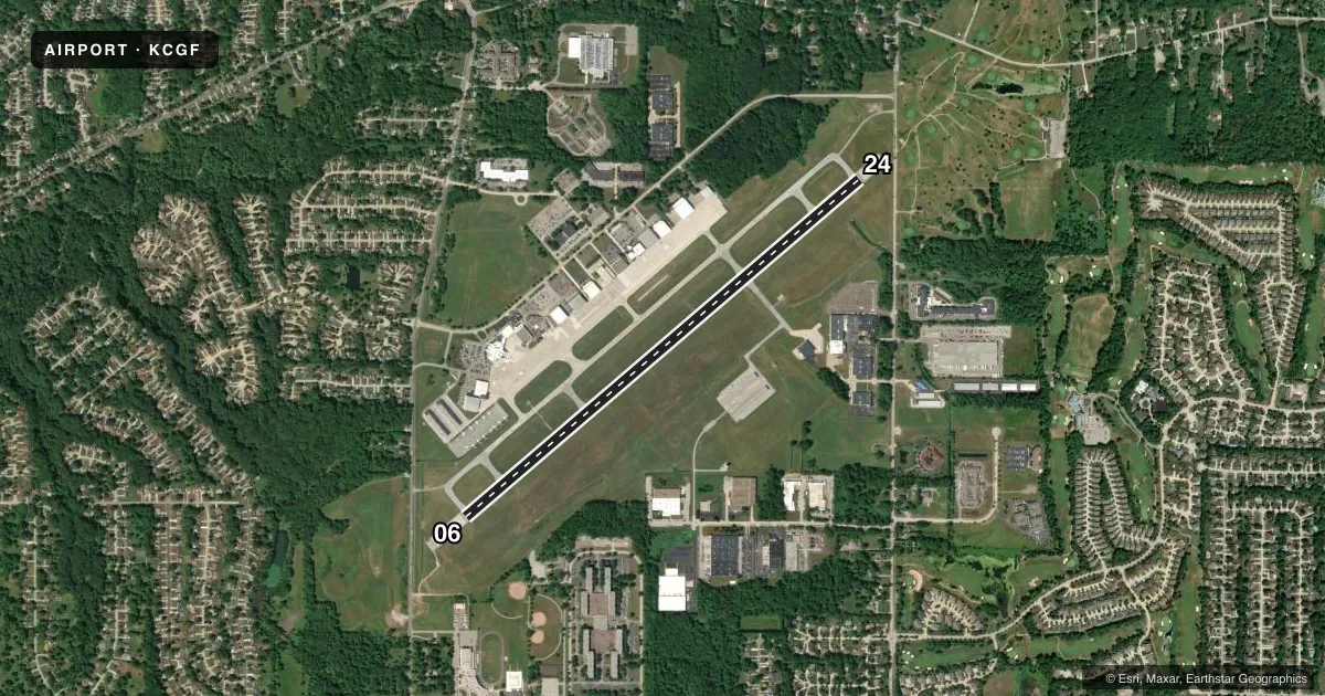
Runways & pattern
Full pagePattern entry · RWY 24
LEFT TRAFFICRunway end performance
| End | TORA | TODA | ASDA | LDA | VGSI | Approach lights | Obstruction |
|---|---|---|---|---|---|---|---|
| 06 | 5,502' | 5,502' | 5,502' | 5,184' | PAPI 4-box left(3°) | — | 86', tree, 1769' from thr, 336' R of cntrln, slope 18 |
| 24 | 5,502' | 5,502' | 5,502' | 5,000' | PAPI 4-box left(3°) | MALSR | 7', road, 201' from thr, 325' R of cntrln, slope 0 |
Declared distances in feet. TORA = takeoff run available, TODA = takeoff distance, ASDA = accelerate-stop, LDA = landing distance.
Airport sketch
Runways drawn to scale from FAA survey coordinates, rendered over satellite imagery. Not for navigation.
Approaches & charts
ILS · 1
Services on the field
Fuel grades, oxygen, maintenance, ramp storage and lighting — as declared to the FAA by the airport operator.
Fuel & services
- Fuel
- 100LLAA+
- Oxygen (bottled)
- High pressure
- Oxygen (bulk)
- Not available
- Airframe repair
- Major
- Power plant repair
- Major
- Other services
- AFRT,AVNCS,CHTR,INSTR,RNTL,SALES
Ramp & ground
- Transient storage
- Tie-down
- Hangar
- Landing fee
- No fee published
- Customs
- Not available
- Lighting schedule
- SEE RMK
- Beacon schedule
- SS-SR
- Beacon
- White / Green (civil land)(WG)
- Wind indicator
- Lighted
- Segmented circle
- No
Fuel & FBOs
Cheapest 100LL and Jet A on the field and nearby. Always confirm with the FBO before taxi.
Airport notes
Surface conditions, obstructions, local procedures, lighting outages and other notes published with each FAA cycle.
General notes
- BIRDS & WILDLIFE ON & INVOF ARPT.
- ATCT VIS SW LTD WI 500 FT AER 06.
- FLT TRG PROHIBITED 2300-0700.
- NOISE ABATEMENT PROCS IN EFCT CALL ARPT.
- FOR CD WHEN ATCT CLSD CTC CLEVELAND APCH AT 216-352-2323.
Lighting notes
- WHEN ATCT CLSD ACTVT WINDSOCKS; MALSR RWY 24; REIL RWY 06; PAPI RWY 06; HIRL RWY 06/24 - CTAF. PAPI RWY 24 OPR CONSLY.
Approach & departure obstructions
- 247 FT ROAD, 0 FT DIST, 525 FT L; 2 FT FENCE, 0 FT DIST, 500 FT L.
- 06APCH SLP 24:1 TO DTHR 86 FT TREES, 2087 FT DIST, 336 FT R.
- 24APCH SLP 50:1 TO DTHR.
- 067 FT ROAD, 703 FT DIST, 325 FT L.
Other notes
- 1FOR AFT HRS SVC CALL 216-261-8800 DRG ATNDD HRS.
- MANAGERCCAIRPORT@CUYAHOGACOUNTY.US.
VFR map & nearby airports
VFR sectional. Tap any ICAO chip to open that airport.
Key facts · KCGF
Answer card- ICAO
- KCGF
- Name
- CUYAHOGA COUNTY
- Location
- CLEVELAND, OHIO
- Elevation
- 876.1 ft MSL
- Traffic pattern altitude
- 1,876.1 ft MSL (1,000 AGL)
- Control tower
- Towered · 0700-2300
- Total runways
- 1
- Longest runway
- 06/24 · 5,502 ft
- Published ILS approaches
- 1
- Published frequencies
- 7
- Magnetic variation
- 8°
- Current flight rules
- MVFR
- Current wind
- 260° at 10 kt
- Favored runway now
- RWY 24
Cuyahoga County Airport sits in Cleveland, Ohio. Field elevation is 876.1 ft MSL. The airport has one runway. Runway 06/24 is 5,502 ft long. The tower is open from 0700 to 2300. One ILS approach is published for runway 24.
Pattern altitude is not published in the facts. For light piston operations, use the standard 1,000 ft AGL unless the current Chart Supplement says otherwise. The field is busy enough to warrant a close read of the local procedures. Noise abatement is in effect. Call the airport for details before you go. Birds and wildlife are also reported on and near the airport.
The Cleveland Jet Center is on the field. It carries 100LL, Jet A and Jet A Prist. Call (216) 261-8800 for current service details or after-hours help during attended hours. When the tower is closed, activate the windsocks. Runway 24 has MALSR lighting. Runway 06 has REIL and PAPI. High intensity runway lights on 06 and 24 operate on CTAF. The PAPI on runway 24 operates continuously.
Watch the runway 06 and 24 approach notes closely. Tower visibility is severely limited within 500 ft above runway 06. Flight training is prohibited from 2300 to 0700. For clearance delivery when the tower is closed, contact Cleveland Approach. Check the current FAA Chart Supplement before departure for the latest procedures and any changes.