METAR & TAF KBVU
Current METAR
Observed 11:35Z
KBVU 271135Z AUTO 00000KT 10SM CLR 34/10 A2987 RMK AO2
- Wind
- 000° @ 0 kt
- Visibility
- 10 SM
- Temp / Dew
- 34°C / 10°C
- Altimeter
- 29.87 inHg
- Clouds
- CLR
- Density alt
- 5,074 ft
- Ceiling
- Unlimited
- Rules
- VFR
Airport info & contacts
Manager on record, flight service, ARTCC, attendance schedule and pattern altitude — published by the FAA and refreshed every 28 days.
Location
- From city
- 1 NM SW
- VFR sectional
- LAS VEGAS
- ARTCC
- ZLA · LOS ANGELES
- NOTAM facility
- RNO (NOTAM-D)
Airport manager
- Name
- MARISSA ADOU
- Phone
- 702-293-9405
- Address
- 1201 AIRPORT ROAD, SUITE 200, BOULDER CITY NV 89005
Flight service · Hours
- FSS RNO
- RENO1-800-WX-BRIEF
- Attendance
- 0800-1700
Frequencies
Tap any row to copy the frequency to your clipboard.
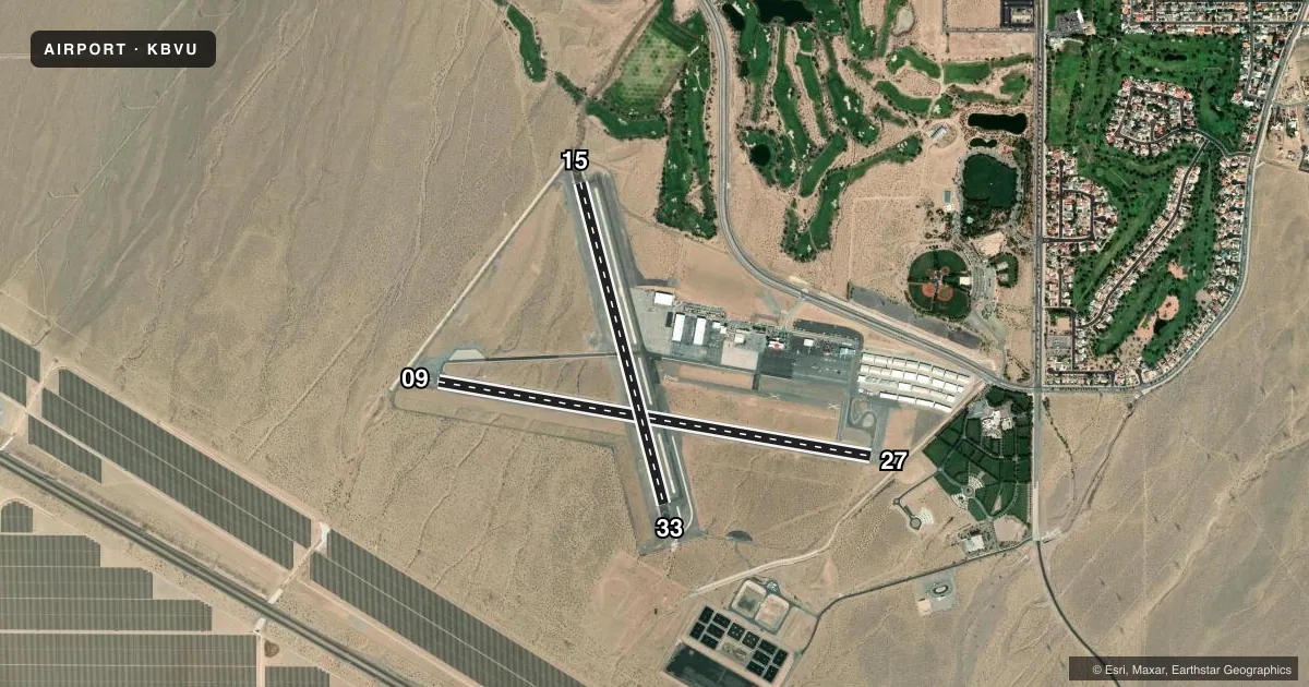
Runways & pattern
Full pagePattern entry · RWY 09
RIGHT TRAFFIC| Runway | Heading (°M) | Length | Surface | Traffic |
|---|---|---|---|---|
| 09/27 | 89° / 269° | 5,103 ft | ASPH | 09 R |
| 15/33 | 154° / 334° | 3,852 ft | ASPH | 15 R |
Runway end performance
| End | TORA | TODA | ASDA | LDA | VGSI | Approach lights | Obstruction |
|---|---|---|---|---|---|---|---|
| 09 | — | — | — | — | PAPI 2-box left(3°) | — | — |
| 27 | — | — | — | — | PAPI 2-box left(3°) | — | 123', pline, 3724' from thr, 0' R of cntrln, slope 29 |
| 15 | — | — | — | — | — | — | 10', gnd, 400' from thr, 0' R of cntrln, slope 20 |
| 33 | — | — | — | — | PAPI 2-box left(3°) | — | — |
Declared distances in feet. TORA = takeoff run available, TODA = takeoff distance, ASDA = accelerate-stop, LDA = landing distance.
Airport sketch
Runways drawn to scale from FAA survey coordinates, rendered over satellite imagery. Not for navigation.
Approaches & charts
Services on the field
Fuel grades, oxygen, maintenance, ramp storage and lighting — as declared to the FAA by the airport operator.
Fuel & services
- Fuel
- 100LLA
- Airframe repair
- Major
- Power plant repair
- Major
- Other services
- AMB,CARGO,CHTR,GLD,INSTR,PAJA,RNTL
Ramp & ground
- Transient storage
- Tie-down
- Hangar
- Landing fee
- No fee published
- Lighting schedule
- SEE RMK
- Beacon schedule
- SS-SR
- Beacon
- White / Green (civil land)(WG)
- Wind indicator
- Lighted
- Segmented circle
- Yes
Fuel & FBOs
Cheapest 100LL and Jet A on the field and nearby. Always confirm with the FBO before taxi.
Airport notes
Surface conditions, obstructions, local procedures, lighting outages and other notes published with each FAA cycle.
General notes
- RWY 33 STEEP RWY GRADIENT; RISING TERRAIN; OBSTACLES OFF DEP END OF RWY.
- AVOID OVERFLIGHT OF BOULDER CITY RESIDENTIAL AREAS.
- UNLIGHTED POWER LINES ALL QUADRANTS.
- UPHILL DEPARTURES ON RWY 33 NOT RECOMMENDED.
- STEEP RISING TERRAIN NORTH OF ARPT.
- ULTRALIGHT ACTIVITY 2 MILES SW OF ARPT INVOF DRY LAKE BED.
- SKYDIVE DROP ZONE ADJACENT AIRPORT NORTH EAST SIDE.
- LARGE NUMBER OF GRAND CANYON TOUR ACFT OPERATIONS IN VICINITY TRANSITING TO & FROM AIRPORT.
- HELICOPTERS CROSS ACTIVE RWYS AND TWYS.
- RWY 27 PREFERRED UNDER LIGHT OR NO WIND CONDITIONS.
- TAXIWAY SHOULDERS ADJ TO TWY D WEST OF RWY 15/33, SOFT GROUND AND DROPS OFF MORE THAN 3 INCHES.
- OPERATIONS IN SOUTHERN NEVADA - UNMANNED AIRCRAFT SYSTEM ACTIVITY WITHIN AN AREA DEFINED AS 3NM RADIUS OF BLD R-197/7NM, SFC-400 FT AGL.
- CTC AP OPS FOR RWY COND RPT, 702-293-9405, OR WHEN THE AP IS UNATNDD.
- FOR ATC ASSISTANCE CALL OR CONTACT LAS VEGAS APCH AT 725-200-4432.
- RWY 15/33 NO RUNUP AREA. RUNUP AREA LCTD ON TWY D AND TWY A.
- LNDG FEE: FOR LNDG FEE SKED, CHECK ARPT WEBSITE OR CTC ARPT
Lighting notes
- ACTVT MIRL RWY 09/27 & 15/33 - CTAF.
Fuel notes
- 100LLSELF SVC 100LL AVBL 24/7 WITH CC.
- ASELF SVC JET-A AVBL 24/7 WITH CC.
Other notes
- MANAGERAIRPORT MANAGER EMAIL: AIRPORTADMIN@BCNV.ORG 702-293-9405
VFR map & nearby airports
VFR sectional. Tap any ICAO chip to open that airport.
Key facts · KBVU
Answer card- ICAO
- KBVU
- Name
- BOULDER CITY MUNI
- Location
- BOULDER CITY, NEVADA
- Elevation
- 2,203.1 ft MSL
- Traffic pattern altitude
- 3,203.1 ft MSL (1,000 AGL)
- Control tower
- Non-towered (use CTAF)
- Total runways
- 2
- Longest runway
- 09/27 · 5,103 ft
- Published ILS approaches
- 0
- Published frequencies
- 4
- Magnetic variation
- 11°
- Current flight rules
- VFR
- Current wind
- 000° at 0 kt
- Favored runway now
- –
Boulder City Muni sits in Boulder City, Nevada. The field elevation is 2,203.1 ft MSL. It has two asphalt runways. The longest is runway 09/27 at 5,103 ft. This is a non-towered airport, so expect self-announced traffic on CTAF 122.7. No ILS approaches are published here. The published pattern altitude is not listed, so use the standard 1,000 ft AGL for light piston operations unless the current FAA Chart Supplement says otherwise.
The field sits in southern Nevada, so density altitude can be a real factor in warm weather. Runway 33 has a steep gradient with rising terrain and obstacles off the departure end. Uphill departures on runway 33 are not recommended. Runways 15/33 also have no runup area. Use taxiway D or taxiway A for runup. There is also ultralight activity about 2 miles southwest near the dry lake bed. A skydive drop zone is adjacent to the airport on the northeast side.
On the field, Boulder City Aviation Services carries 100LL and Jet A. B.F.E. also carries 100LL and Jet A. Self-serve 100LL and Jet A are available 24 hours a day with credit card. For ATC help, Las Vegas Approach is the published approach control. Check the current FAA Chart Supplement for any local restrictions before you go.