METAR & TAF KBVI
Current METAR
Observed 18:35Z
KBVI 271835Z AUTO 25005KT 10SM SCT028 SCT036 SCT048 30/20 A2987 RMK AO2 T02980203
- Wind
- 250° @ 5 kt
- Visibility
- 10 SM
- Temp / Dew
- 30°C / 20°C
- Altimeter
- 29.87 inHg
- Clouds
- SCT
- Density alt
- 3,415 ft
- Ceiling
- Unlimited
- Rules
- VFR
Airport info & contacts
Manager on record, flight service, ARTCC, attendance schedule and pattern altitude — published by the FAA and refreshed every 28 days.
Location
- From city
- 3 NM NW
- VFR sectional
- DETROIT
- ARTCC
- ZOB · CLEVELAND
- NOTAM facility
- BVI (NOTAM-D)
Airport manager
- Name
- TIMOTHY NESTOR
- Phone
- 724-847-4662
- Address
- 15 PIPER ST, BEAVER FALLS PA 15010
Flight service · Hours
- FSS AOO
- ALTOONA1-800-WX-BRIEF
- Attendance
- MON-FRI · 0700-2100
- SAT-SUN · 0900-1600
- Unattended · FED HOL
Frequencies
Tap any row to copy the frequency to your clipboard.
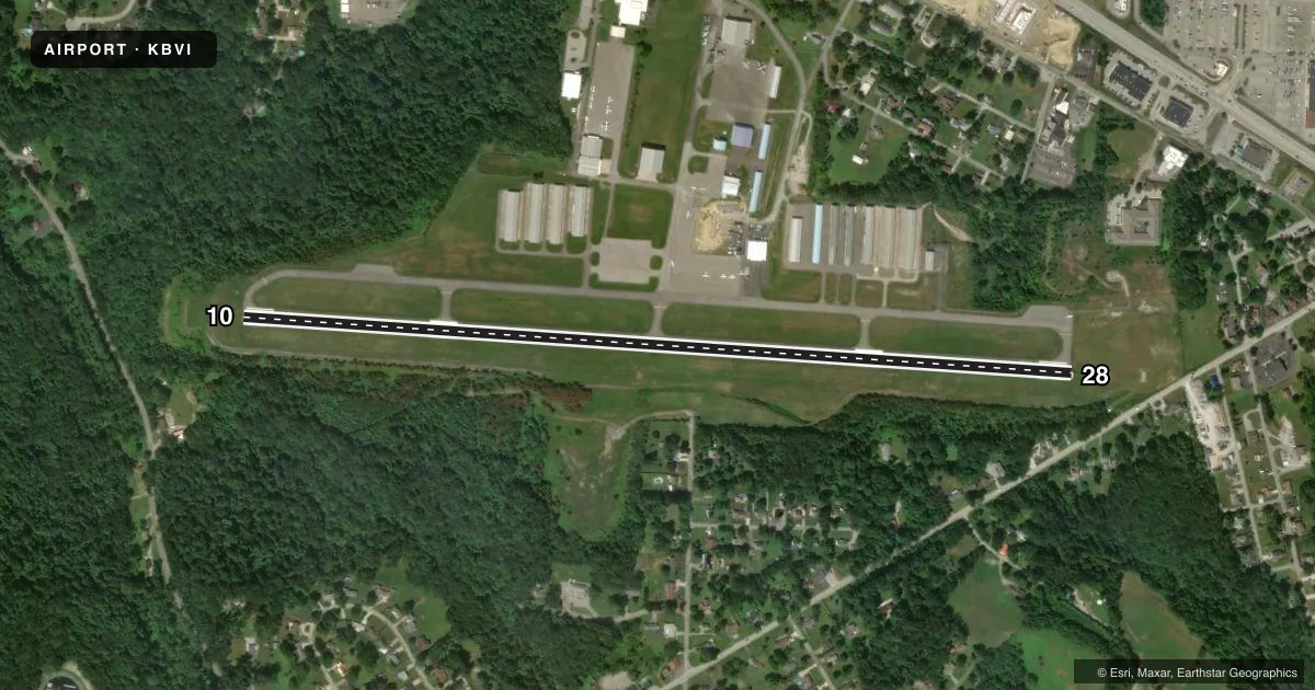
Runways & pattern
Full pagePattern entry · RWY 28
LEFT TRAFFICRunway end performance
| End | TORA | TODA | ASDA | LDA | VGSI | Approach lights | Obstruction |
|---|---|---|---|---|---|---|---|
| 10 | — | — | — | — | PAPI 4-box left(3°) | — | 78', trees, 1759' from thr, 286' R of cntrln, slope 19 |
| 28 | — | — | — | — | PAPI 4-box left(3°) | — | 18', trees, 622' from thr, 117' R of cntrln, slope 23 |
Declared distances in feet. TORA = takeoff run available, TODA = takeoff distance, ASDA = accelerate-stop, LDA = landing distance.
Airport sketch
Runways drawn to scale from FAA survey coordinates, rendered over satellite imagery. Not for navigation.
Approaches & charts
ILS · 1
Services on the field
Fuel grades, oxygen, maintenance, ramp storage and lighting — as declared to the FAA by the airport operator.
Fuel & services
- Fuel
- 100LLAA+
- Oxygen (bottled)
- Not available
- Oxygen (bulk)
- Not available
- Airframe repair
- Major
- Power plant repair
- Major
- Other services
- AFRT,AMB,AVNCS,CHTR,INSTR,RNTL,SURV
Ramp & ground
- Transient storage
- Tie-down
- Hangar
- Landing fee
- No fee published
- Customs
- Not available
- Lighting schedule
- SEE RMK
- Beacon schedule
- SS-SR
- Beacon
- White / Green (civil land)(WG)
- Wind indicator
- Lighted
- Segmented circle
- No
Fuel & FBOs
Cheapest 100LL and Jet A on the field and nearby. Always confirm with the FBO before taxi.
Airport notes
Surface conditions, obstructions, local procedures, lighting outages and other notes published with each FAA cycle.
General notes
- (E94) SAWRS.
- NOISE ABATEMENT PROCS IN EFCT FOR DEPS ONLY, CTC AMGR 0800-1600 FOR DTLS AT 724-847-4662.
Lighting notes
- ATCT-CTL. WHEN ATCT CLSD MIRL RWY 10/28 & TWY LGTS OPER LOW INTST. INCR INTST & ACTVT REIL RWY 10 & 28 - CTAF. PAPI RWY 10 & 28 OPER CONT.
Approach & departure obstructions
- 28RWY 28: 20 FT TREES, 13 FT FM RWY END, 195 FT LEFT.
- 28RWY 28 REILS OTS INDEFLY.
Other notes
- EXISTED PRIOR TO 1959.
VFR map & nearby airports
VFR sectional. Tap any ICAO chip to open that airport.
Key facts · KBVI
Answer card- ICAO
- KBVI
- Name
- BEAVER COUNTY
- Location
- BEAVER FALLS, PENNSYLVANIA
- Elevation
- 1,252.7 ft MSL
- Traffic pattern altitude
- 2,252.7 ft MSL (1,000 AGL)
- Control tower
- Towered · 0730-1930 MON-FRI; CLSD SAT-SUN.
- Total runways
- 1
- Longest runway
- 10/28 · 4,501 ft
- Published ILS approaches
- 1
- Published frequencies
- 8
- Magnetic variation
- 7°
- Current flight rules
- VFR
- Current wind
- 250° at 5 kt
- Favored runway now
- RWY 28
Beaver County Airport sits in Beaver Falls, Pennsylvania. The field elevation is 1,252.7 ft MSL. It has one runway, 10/28, which is 4,501 ft long. The airport is towered. The tower is open 0730-1930 Monday through Friday. It is closed Saturday and Sunday.
Runway 10 has the ILS approach. The published pattern altitude is not given, so use standard 1,000 ft AGL for light piston traffic unless ATC or the current Chart Supplement says otherwise. That puts the pattern at about 2,252.7 ft MSL based on the field elevation. Verify before you fly. The airport sits in the Pittsburgh area. Expect busy radio work and stay sharp on the Class B procedures nearby. Check the current Chart Supplement and the sectional or TAC if you need the airspace picture for your route.
Two FBOs are on the field. Moore Aviation carries 100LL and Jet A. AirQuest Aviation carries 100LL, Jet A and Jet A Prist. Noise abatement applies to departures only. Call the airport manager for the current details before departure. Runway 28 also has a published tree obstruction near the end, so review the runway environment carefully if you plan to use that direction. When the tower is closed, runway and taxiway lighting stays available at low intensity. Pilots can increase the intensity and activate runway end identifier lights on CTAF. The PAPI for both runway ends operates continuously.