METAR & TAF KART
Current METAR
Observed 18:56Z
KART 271856Z AUTO 27013KT 10SM CLR 26/19 A2978 RMK AO2 SLP080 T02610194
- Wind
- 270° @ 13 kt
- Visibility
- 10 SM
- Temp / Dew
- 26°C / 19°C
- Altimeter
- 29.78 inHg
- Clouds
- CLR
- Density alt
- 1,904 ft
- Ceiling
- Unlimited
- Rules
- VFR
Airport info & contacts
Manager on record, flight service, ARTCC, attendance schedule and pattern altitude — published by the FAA and refreshed every 28 days.
Location
- From city
- 5 NM W
- VFR sectional
- NEW YORK
- ARTCC
- ZBW · BOSTON
- NOTAM facility
- ART (NOTAM-D)
Airport manager
- Name
- GRANT W. SUSSEY
- Phone
- 315-786-6002
- Address
- 22529 AIRPORT DR, DEXTER NY 13634-3062
Flight service · Hours
- FSS BTV
- BURLINGTON1-800-WX-BRIEF
- Attendance
- OCT-APR · 0600-1800
- MAY-SEP · 0500-1900
Frequencies
Tap any row to copy the frequency to your clipboard.
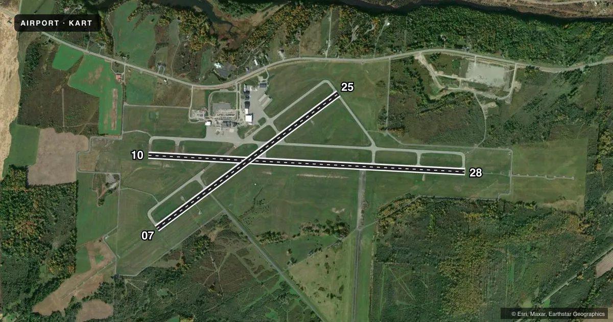
Runways & pattern
Full pagePattern entry · RWY 28
LEFT TRAFFIC| Runway | Heading (°M) | Length | Surface | Traffic |
|---|---|---|---|---|
| 10/28Favored | 81° / 261° | 7,001 ft | ASPH | Standard L |
| 07/25 | 41° / 221° | 4,999 ft | ASPH | Standard L |
Runway end performance
| End | TORA | TODA | ASDA | LDA | VGSI | Approach lights | Obstruction |
|---|---|---|---|---|---|---|---|
| 10 | 7,001' | 7,001' | 7,001' | 7,001' | PAPI 4-box left(3°) | — | 85', trees, 2700' from thr, 620' R of cntrln, slope 29 |
| 28 | 7,001' | 7,001' | 7,001' | 7,001' | PAPI 4-box left(3°) | MALSR | 85', trees, 2720' from thr, 90' R of cntrln, slope 30 |
| 07 | 4,999' | 4,999' | 4,784' | 4,784' | PAPI 4-box left(3°) | MALSR | 75', trees, 1520' from thr, 330' R of cntrln, slope 17 |
| 25 | 4,999' | 4,999' | 4,999' | 4,999' | PAPI 4-box left(3°) | — | 70', trees, 1095' from thr, 520' R of cntrln, slope 13 |
Declared distances in feet. TORA = takeoff run available, TODA = takeoff distance, ASDA = accelerate-stop, LDA = landing distance.
Airport sketch
Runways drawn to scale from FAA survey coordinates, rendered over satellite imagery. Not for navigation.
Approaches & charts
ILS · 1
Services on the field
Fuel grades, oxygen, maintenance, ramp storage and lighting — as declared to the FAA by the airport operator.
Fuel & services
- Fuel
- 100LLA
- Airframe repair
- Major
- Power plant repair
- Major
- Other services
- AMB,CARGO,INSTR,RNTL
Ramp & ground
- Transient storage
- Tie-down
- Hangar
- Landing fee
- No fee published
- Customs
- Available
- Lighting schedule
- SEE RMK
- Beacon schedule
- SS-SR
- Beacon
- White / Green (civil land)(WG)
- Wind indicator
- Lighted
Fuel & FBOs
Cheapest 100LL and Jet A on the field and nearby. Always confirm with the FBO before taxi.
Airport notes
Surface conditions, obstructions, local procedures, lighting outages and other notes published with each FAA cycle.
General notes
- DEER & BIRDS ON & INVOF ARPT.
- MIL HEL T ON & INVOF ARPT.
- PPR FOR USE OF UNIMPROVED SFCS - AMGR.
- TKS DE/ANTI ICING AVBL - FBO 315-786-6001.
- RWY/TWY COND UNMNTD AFT HRS.
- PAEW ALL SFCS APR-OCT. SN REMOVAL EQUIP OCT-APR.
- CTN: NGT VISION DEVICE OPS CONDUCTED IN TFC PAT AREA.
- RC MODEL ACT 4 NM N & 9 NM SSW BLW 400 FT.
- TWY LGTS NOT VSB USING NGT VISION GOGGLES.
- APN PRKG WT BRG CPTY: 68/F/C/X/T; S-120, D-239, DT-385.
- WX CAMERA AVBL AT WATERTOWNAIRPORT.COM.
- FOR CD IF UNA TO CTC WHEELER SACK ATCT ON FREQ, CTC WHEELER SACK ATCT AT 315-772-7105.
- CTN: RAPID HOT REFUELING ON TRML & GA RAMP.
- GND VEHICLES MNT CTAF.
- US CUSTOMS PRKG AT GA RAMP UNLESS ADZD BY CUSTOMS OR FBO.
- TKS, TYPE I & IV FLUIDS AVBL - CTC FBO.
- 24HR PPR FOR TRNSPN OF XPLOS - CTC AMGR.
- MEDEVAC ON ARPT. GIVEAWAY TO ACFT OR HEL USING MEDEVAC CS.
- WHEELED HEL REQSTD TO GND TAXI WHEN XNG GA RAMP.
Lighting notes
- ACTVT MALSR RWY 07 & 28; REIL RWY 25; HIRL RWY 07/25; MIRL RWY 10/28; TWY LGTS - CTAF. PAPI RWYS 7, 10, 25 & 28 OPR CONSLY.
Fuel notes
- 100LLFUEL AFT HRS: 315-816-2334 OR 315-466-6741.
Runway surface & condition
- 07/25PCR VALUE: 601/F/D/X/T
- 10/28PCR VALUE: 270/F/D/X/T
- 07/25RWY 25 CALM WIND RWY.
Other notes
- FILED FOR RECORD PURPOSES ONLY.
- 2 HR PPR - US CUSTOMS 315-482-2261.
- PPR 2 HRS FOR UNSKD OPS WITH MORE THAN 30 PAX SEATS CALL 315-816-2331 OR 315-486-3302. INDEX B COVERAGE IS AVBL O/R.
- LNDG FEE OVR 6000 LB.
VFR map & nearby airports
VFR sectional. Tap any ICAO chip to open that airport.
Key facts · KART
Answer card- ICAO
- KART
- Name
- WATERTOWN INTL
- Location
- WATERTOWN, NEW YORK
- Elevation
- 330.8 ft MSL
- Traffic pattern altitude
- 1,330.8 ft MSL (1,000 AGL)
- Control tower
- Non-towered (use CTAF)
- Total runways
- 2
- Longest runway
- 10/28 · 7,001 ft
- Published ILS approaches
- 1
- Published frequencies
- 5
- Magnetic variation
- 12°
- Current flight rules
- VFR
- Current wind
- 270° at 13 kt
- Favored runway now
- RWY 28
Watertown Intl sits in Watertown, New York. Field elevation is 330.8 ft MSL. The airport has two asphalt runways. The longest is runway 10/28 at 7,001 ft. There is no control tower, so expect non-towered procedures on CTAF 123.0. Pattern altitude is not published in the facts. Use the current Chart Supplement before you go. One ILS is published for runway 07.
The on-field FBO is Watertown International Airport. It carries 100LL and Jet A Prist. If you need fuel or ramp details, call ahead at (315) 786-6001. Published remarks show MALSR lighting on runways 07 and 28. REIL is on runway 25. PAPI is listed for all runway ends. That helps after dark or in lower visibility.
This field also has customs-related procedures. Two hours prior permission is required for U.S. Customs. Unscheduled operations with more than 30 passenger seats also need prior permission two hours in advance. The airport notes landing fees for aircraft over 6,000 lb. Ground vehicles use the common traffic advisory frequency. If you are planning a first visit, review the current Chart Supplement for any local procedures before arrival. The field is close to the lake and the region can see winter weather. Plan for that in your fuel and alternates.