METAR & TAF KACV
Current METAR
Observed 15:53Z
KACV 271553Z AUTO 33006KT 10SM OVC013 15/12 A3010 RMK AO2 SLP195 T01500117
- Wind
- 330° @ 6 kt
- Visibility
- 10 SM
- Temp / Dew
- 15°C / 12°C
- Altimeter
- 30.10 inHg
- Clouds
- OVC
- Density alt
- 52 ft
- Ceiling
- 1,300 ft AGL
- Rules
- MVFR
Airport info & contacts
Manager on record, flight service, ARTCC, attendance schedule and pattern altitude — published by the FAA and refreshed every 28 days.
Location
- From city
- 7 NM N
- VFR sectional
- KLAMATH FALLS
- ARTCC
- ZSE · SEATTLE
- NOTAM facility
- ACV (NOTAM-D)
Airport manager
- Name
- JUSTIN HOPMAN
- Phone
- 707-382-2551
- Address
- 3561 BOEING AVE., MCKINLEYVILLE CA 95519
Flight service · Hours
- FSS OAK
- OAKLAND1-800-WX-BRIEF
- Attendance
- 0400-2359
Frequencies
Tap any row to copy the frequency to your clipboard.
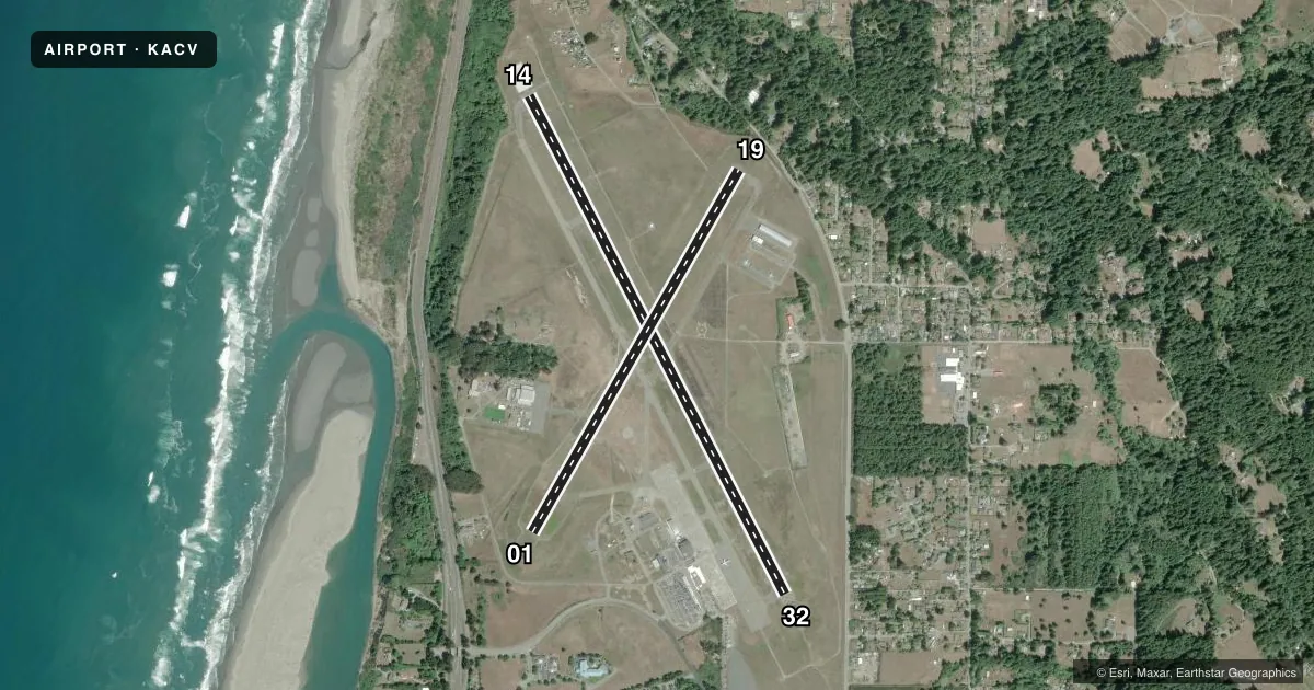
Runways & pattern
Full pagePattern entry · RWY 32
LEFT TRAFFIC| Runway | Heading (°M) | Length | Surface | Traffic |
|---|---|---|---|---|
| 14/32Favored | 136° / 316° | 6,046 ft | ASPH | 14 R |
| 01/19 | 13° / 193° | 4,501 ft | ASPH | 19 R |
Runway end performance
| End | TORA | TODA | ASDA | LDA | VGSI | Approach lights | Obstruction |
|---|---|---|---|---|---|---|---|
| 14 | 6,046' | 6,046' | 5,846' | 5,601' | PAPI 4-box left(3°) | — | — |
| 32 | 6,046' | 6,046' | 6,046' | 5,846' | PAPI 4-box left(3°) | MALSR | 91', tree, 2625' from thr, 875' R of cntrln, slope 26 |
| 01 | 4,501' | 4,501' | 4,501' | 4,501' | VASI 4-box left(3°) | — | — |
| 19 | 4,501' | 4,501' | 4,501' | 4,501' | — | — | 142', trees, 3450' from thr, slope 23 |
Declared distances in feet. TORA = takeoff run available, TODA = takeoff distance, ASDA = accelerate-stop, LDA = landing distance.
Airport sketch
Runways drawn to scale from FAA survey coordinates, rendered over satellite imagery. Not for navigation.
Approaches & charts
ILS · 1
Services on the field
Fuel grades, oxygen, maintenance, ramp storage and lighting — as declared to the FAA by the airport operator.
Fuel & services
- Fuel
- 100LLA
- Oxygen (bottled)
- Not available
- Oxygen (bulk)
- Not available
- Airframe repair
- Not available
- Power plant repair
- Not available
- Other services
- CARGO
Ramp & ground
- Transient storage
- Tie-down
- Landing fee
- Yes
- Customs
- Not available
- Lighting schedule
- SEE RMK
- Beacon schedule
- SS-SR
- Beacon
- White / Green (civil land)(WG)
- Wind indicator
- Lighted
- Segmented circle
- Yes
Fuel & FBOs
Cheapest 100LL and Jet A on the field and nearby. Always confirm with the FBO before taxi.
Airport notes
Surface conditions, obstructions, local procedures, lighting outages and other notes published with each FAA cycle.
General notes
- FOR CD IF UNA TO CTC ON FSS FREQ, CTC SEATTLE ARTCC AT 253-351-3694.
Lighting notes
- ACTVT MALSR RWY 32; TDZL RWY 32; C/L LGTS RWY 14 & 32; REIL RWY 14; PAPI RWY 14 & 32; HIRL RWY 14/32 - CTAF. MIRL RWY 01/19, REIL RWY 01, AND VASI RWY 01 PPR CTC 707-382-2551 OR 707-496-0102.
Fuel notes
- 100LLFUEL AVBL 0400-2400 LOCAL, AND AFTER HOURS WITH ADVANCED NOTICE.
Runway surface & condition
- 01/19PCR VALUE: 62/F/D/X/U
- 14/32PCR VALUE: 530/F/D/X/T
- 01/19RWY 01/19 NOT AVBL FOR PART 121/PART 380 OPS WITH SKED PAX CARRYING OPS MORE THAN 9 PAX SEATS AND NON-SKED PAX CARRYING OPS MORE THAN 30 PAX SEATS.
Arresting gear
- 32_EMASENGINEERED MATERIAL ARRESTING SYSTEM (EMAS) 280 FT IN LEN BY 170 FT IN WID STARTING 70 FT BYD DER 32.
Other notes
- LNDG FEE: CTC ARPT OR CHECK ARPT WEBSITE FOR DTLS, EXEMPTIONS.
- MANAGEREMAIL: JHOPMAN@CO.HUMBOLDT.CA.US
VFR map & nearby airports
VFR sectional. Tap any ICAO chip to open that airport.
Key facts · KACV
Answer card- ICAO
- KACV
- Name
- CALIFORNIA REDWOOD COAST-HUMBOLDT COUNTY
- Location
- ARCATA/EUREKA, CALIFORNIA
- Elevation
- 222.3 ft MSL
- Traffic pattern altitude
- 1,222.3 ft MSL (1,000 AGL)
- Control tower
- Non-towered (use CTAF)
- Total runways
- 2
- Longest runway
- 14/32 · 6,046 ft
- Published ILS approaches
- 1
- Published frequencies
- 2
- Magnetic variation
- 17°
- Current flight rules
- MVFR
- Current wind
- 330° at 6 kt
- Favored runway now
- RWY 32
California Redwood Coast-Humboldt County is in Arcata/Eureka, California. The field elevation is 222.3 ft MSL. It has two asphalt runways. The longest is runway 14/32 at 6,046 ft. Runway 01/19 is 4,501 ft. There is no control tower. CTAF and UNICOM are both 123.0.
Runway 32 has the ILS. The published pattern altitude is not given in the facts, so use the current FAA Chart Supplement before you fly. The airport sits on the North Coast, so weather and coastal marine layers can matter on arrival and departure. Runway 32 also has MALSR, touchdown zone lights, centerline lights and an EMAS beyond the departure end. Runway 14 and 32 have high intensity lights that use the CTAF frequency.
Arcata Airport is the on-field FBO. It carries 100LL, Jet A and Jet A Prist. 100LL is available from 0400 to 2400 local time. After-hours fuel is available with advanced notice. For clearance delivery, if you cannot reach flight service, the published remark points pilots to Seattle ARTCC. If you need runway 01 lighting, prior permission is required. Check the current Chart Supplement for any noise, curfew, or other local operating restrictions before flying in.