METAR & TAF F45
Current METAR
Observed 17:15Z
KF45 271715Z AUTO VRB04KT 10SM SCT036 33/23 A2993 RMK AO2
- Wind
- VAR @ 4 kt
- Visibility
- 10 SM
- Temp / Dew
- 33°C / 23°C
- Altimeter
- 29.93 inHg
- Clouds
- SCT
- Density alt
- 2,175 ft
- Ceiling
- Unlimited
- Rules
- VFR
Airport info & contacts
Manager on record, flight service, ARTCC, attendance schedule and pattern altitude — published by the FAA and refreshed every 28 days.
Location
- From city
- 12 NM NW
- VFR sectional
- MIAMI
- ARTCC
- ZMA · MIAMI
- NOTAM facility
- MIA (NOTAM-D)
Airport manager
- Name
- LAURA BEEBE
- Phone
- 561-471-7420
- Address
- 846 PALM BEACH INTL AIRPORT, WEST PALM BEACH FL 33406-1470
Flight service · Hours
- FSS MIA
- MIAMI1-800-WX-BRIEF
- Attendance
- ALL
Frequencies
Tap any row to copy the frequency to your clipboard.
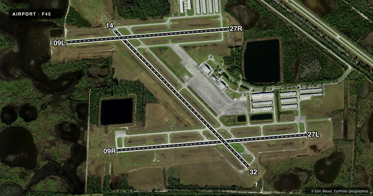
Runways & pattern
Full pagePattern entry · RWY 32
LEFT TRAFFIC| Runway | Heading (°M) | Length | Surface | Traffic |
|---|---|---|---|---|
| 14/32Favored | 128° / 308° | 4,300 ft | ASPH | 14 R |
| 09R/27L | 78° / 258° | 4,300 ft | ASPH | 09R R |
| 09L/27R | 78° / 258° | 3,679 ft | TURF | 27R R |
Runway end performance
| End | TORA | TODA | ASDA | LDA | VGSI | Approach lights | Obstruction |
|---|---|---|---|---|---|---|---|
| 14 | — | — | — | — | PAPI 2-box left(3°) | — | 51', trees, 2065' from thr, 115' R of cntrln, slope 37 |
| 32 | — | — | — | — | PAPI 2-box left(3°) | — | 33', trees, 910' from thr, 185' R of cntrln, slope 22 |
| 09R | — | — | — | — | PAPI 2-box left(3°) | — | — |
| 27L | — | — | — | — | PAPI 2-box left(3°) | — | 75', tree, 2820' from thr, 75' R of cntrln, slope 35 |
| 09L | — | — | — | — | — | — | 67', tree, 1655' from thr, 65' R of cntrln, slope 25 |
| 27R | — | — | — | — | — | — | 67', tree, 1560' from thr, 45' R of cntrln, slope 23 |
Declared distances in feet. TORA = takeoff run available, TODA = takeoff distance, ASDA = accelerate-stop, LDA = landing distance.
Airport sketch
Runways drawn to scale from FAA survey coordinates, rendered over satellite imagery. Not for navigation.
Approaches & charts
ILS · 1
Services on the field
Fuel grades, oxygen, maintenance, ramp storage and lighting — as declared to the FAA by the airport operator.
Fuel & services
- Fuel
- 100LLA
- Airframe repair
- Major
- Power plant repair
- Major
- Other services
- AVNCS,CHTR,INSTR,RNTL,SALES
Ramp & ground
- Transient storage
- Tie-down
- Hangar
- Lighting schedule
- SEE RMK
- Beacon schedule
- SS-SR
- Beacon
- White / Green (civil land)(WG)
- Wind indicator
- Lighted
Fuel & FBOs
Cheapest 100LL and Jet A on the field and nearby. Always confirm with the FBO before taxi.
Airport notes
Surface conditions, obstructions, local procedures, lighting outages and other notes published with each FAA cycle.
General notes
- NOISE ABATEMENT PROC; RWY 14/32 PREFERRED NGT RWY; H24 NOISE ABATEMENT MNTG - (561) 626-7631.
- BIRD ACT INVOF ARPT.
- EXTSV FLT TRNG MULT RWYS. PRACTICE APCH RWY 9R/27L MNT CTAF & YIELD TO TFC PAT.
- TWY G1 CLSD.
- ARPT SFC COND NOT RPRTD FOR ALL RWYS.
- FOR CD CTC PALM BEACH APCH AT 561-684-9047.
- FBO SVC FEE MAY APPLY.
- 24 HR PPR REQSTD FOR ALL ACFT EQUIPPED WITH WEATHER MODIFICATION EQPT OR ACFT CPBL OF WEATHER MODIFICATION AND/OR GEOENGINEERING BY CTC THE DEPT OF ARPT COMMUNICATIONS CNTR AT (561) 471-7420.
Lighting notes
- DUSK-2100; AFT 2100 ACTVT REIL RWY 09R, 14, 27L, & 32; MIRL RWY 09R/27L & 14/32 - CTAF.
Approach & departure obstructions
- 09LPVC PIPE EV 200 FT.
- 14THR MKR 4 FT BYD RWY END.
- 27R09L/27R THLDS MKD WITH PVC PIPES.
Other notes
- MANAGER561-626-9771
VFR map & nearby airports
VFR sectional. Tap any ICAO chip to open that airport.
Key facts · F45
Answer card- ICAO
- F45
- Name
- NORTH PALM BEACH COUNTY GENERAL AVIATION
- Location
- WEST PALM BEACH, FLORIDA
- Elevation
- 22 ft MSL
- Traffic pattern altitude
- 1,022 ft MSL (1,000 AGL)
- Control tower
- Non-towered (use CTAF)
- Total runways
- 3
- Longest runway
- 14/32 · 4,300 ft
- Published ILS approaches
- 1
- Published frequencies
- 5
- Magnetic variation
- 7°
- Current flight rules
- VFR
- Current wind
- 000° at 4 kt
- Favored runway now
- RWY 32
North Palm Beach County General Aviation sits in West Palm Beach, Florida. Field elevation is 22 ft MSL. The airport has three runways. The longest are 4,300 ft. Those are 09R/27L and 14/32. Runway 09L/27R is turf at 3,679 ft. There is no control tower. Check the current FAA Chart Supplement for the latest tower, airspace and any local operating details before you go.
One ILS is published. It serves runway 09R. Pattern altitude is not published in the facts block. Use the standard 1,000 ft AGL for light piston operations unless the current Chart Supplement says otherwise. Signature Aviation is on the field. It carries 100LL and Jet A. The airport has published noise abatement in effect. Runway 14/32 is the preferred night runway. Lighting is available from dusk to 2100. After 2100, runway end identifier lights must be activated on 09R, 14, 27L and 32. Medium intensity runway lights are on 09R/27L and 14/32. Taxiway G1 is closed. Expect a busy training environment. Bird activity is also reported in the area.