METAR & TAF E06
E06 does not publish a METAR.
Showing the nearest reporting station: KHOB (LEA COUNTY RGNL) · 18.7 NM away. Conditions at E06 may differ.
METAR · KHOB
Observed 21:50Z
KHOB 272150Z 10010G18KT 10SM CLR 39/10 A2994
- Wind
- 100° @ 10G18 kt
- Visibility
- 10 SM
- Temp / Dew
- 39°C / 10°C
- Altimeter
- 29.94 inHg
- Clouds
- CLR
- Density alt
- 7,789 ft
- Ceiling
- Unlimited
- Rules
- VFR
Airport info & contacts
Manager on record, flight service, ARTCC, attendance schedule and pattern altitude — published by the FAA and refreshed every 28 days.
Location
- From city
- 3 NM W
- VFR sectional
- ALBUQUERQUE
- ARTCC
- ZFW · FORT WORTH
- NOTAM facility
- ABQ (NOTAM-D)
Airport manager
- Name
- COREY NEEDHAM
- Phone
- 575-391-2934
- Address
- PO BOX 1106, HOBBS NM 88241-1106
Flight service · Hours
- FSS ABQ
- ALBUQUERQUE1-800-WX-BRIEF
- Attendance
- Unattended
Frequencies
Tap any row to copy the frequency to your clipboard.
Runways & pattern
Full pagePattern entry · RWY 12
LEFT TRAFFIC| Runway | Heading (°M) | Length | Surface | Traffic |
|---|---|---|---|---|
| 03/21 | 38° / 218° | 6,001 ft | ASPH | Standard L |
| 12/30Favored | 131° / 311° | 4,409 ft | ASPH | Standard L |
Runway end performance
| End | TORA | TODA | ASDA | LDA | VGSI | Approach lights | Obstruction |
|---|---|---|---|---|---|---|---|
| 03 | — | — | — | — | PAPI 2-box left(3°) | — | — |
| 21 | — | — | — | — | PAPI 2-box left(3°) | — | — |
| 12 | — | — | — | — | PAPI 2-box left(3°) | — | — |
| 30 | — | — | — | — | PAPI 2-box left(3°) | — | — |
Declared distances in feet. TORA = takeoff run available, TODA = takeoff distance, ASDA = accelerate-stop, LDA = landing distance.
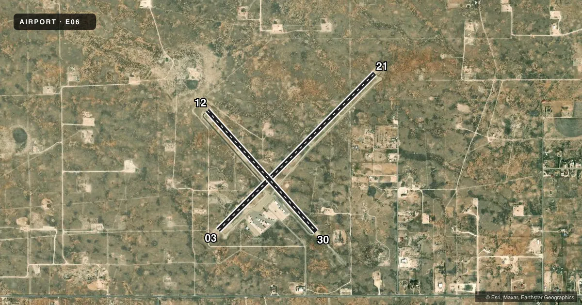
Airport sketch
Runways drawn to scale from FAA survey coordinates, rendered over satellite imagery. Not for navigation.
Approaches & charts
Services on the field
Fuel grades, oxygen, maintenance, ramp storage and lighting — as declared to the FAA by the airport operator.
Fuel & services
- Fuel
- Not available
Ramp & ground
- Transient storage
- Tie-down
- Landing fee
- No fee published
- Customs
- Not available
- Lighting schedule
- SEE RMK
- Beacon schedule
- SS-SR
- Beacon
- White / Green (civil land)(WG)
- Wind indicator
- Lighted
- Segmented circle
- Yes
Fuel & FBOs
Cheapest 100LL and Jet A on the field and nearby. Always confirm with the FBO before taxi.
Airport notes
Surface conditions, obstructions, local procedures, lighting outages and other notes published with each FAA cycle.
General notes
- OIL DRILLING ACT ON & INVOF ARPT.
- EMERG - 575-396-3611.
- GATE CODE - 1228#
- FOR CD CTC FORT WORTH ARTCC AT 817-858-7584.
Lighting notes
- DUSK-DAWN: MIRL RWY 03/21 & 12/30 PRESET LOW INTST; INCR INTST - CTAF. ACTVT PAPI RWY 03, 12, 21 & 30; MIRL RWY 03/21 & 12/30 - CTAF.
Approach & departure obstructions
- 03+3 FT PIPES 700 FT FM THR 60 FT R OF CNTRLN.
- 03UNUSBL BYD 9 DEGS RIGHT & LEFT OF CNTRLN.
- 21UNUSBL BYD 8 DEG RIGHT OF CNTRLN.
- 30UNUSBL BYD 8 DEG RIGHT OF CNTRLN.
VFR map & nearby airports
VFR sectional. Tap any ICAO chip to open that airport.
Key facts · E06
Answer card- ICAO
- E06
- Name
- LEA COUNTY/ZIP FRANKLIN MEML
- Location
- LOVINGTON, NEW MEXICO
- Elevation
- 3,979.2 ft MSL
- Traffic pattern altitude
- 4,979.2 ft MSL (1,000 AGL)
- Control tower
- Non-towered (use CTAF)
- Total runways
- 2
- Longest runway
- 03/21 · 6,001 ft
- Published ILS approaches
- 0
- Published frequencies
- 2
- Magnetic variation
- 7°
- Current flight rules
- VFR
- Current wind
- 100° at 10 kt
- Favored runway now
- RWY 12
LEA COUNTY/ZIP FRANKLIN MEML sits in Lovington, New Mexico. Field elevation is 3,979.2 ft MSL. It is an uncontrolled airport with CTAF and UNICOM both on 122.8. The field has two asphalt runways. The longest is runway 03/21 at 6,001 ft. Runway 12/30 is 4,409 ft.
No ILS approaches are published here. Pattern altitude is not published, so use the standard 1,000 ft AGL for light piston traffic unless the current FAA Chart Supplement says otherwise. That puts the pattern at about 4,979 ft MSL based on the published field elevation. Runway lighting is pilot-controlled on CTAF. The medium intensity lights are preset to low from dusk to dawn. The PAPI is available on runways 03, 12, 21 and 30.
No on-field FBOs are listed in the facts. Verify fuel and services before you go. Published remarks also note gate code 1228#. Oil drilling activity is on and near the airport. Expect local traffic and activity in the area. Runway 03 has a published centerline limit. Runway 21 and runway 30 also have published centerline limits. Runway 03 has +3 ft pipes 700 ft from the threshold, 60 ft right of centerline. Check the current FAA Chart Supplement for the latest operational notes before arrival.