METAR & TAF 9S2
Current METAR
Observed 21:15Z
K9S2 262115Z AUTO 30013G21KT 10SM CLR 33/09 A2986 RMK AO2
- Wind
- 300° @ 13G21 kt
- Visibility
- 10 SM
- Temp / Dew
- 33°C / 9°C
- Altimeter
- 29.86 inHg
- Clouds
- CLR
- Density alt
- 5,253 ft
- Ceiling
- Unlimited
- Rules
- VFR
Airport info & contacts
Manager on record, flight service, ARTCC, attendance schedule and pattern altitude — published by the FAA and refreshed every 28 days.
Location
- From city
- 1 NM NW
- VFR sectional
- BILLINGS
- ARTCC
- ZLC · SALT LAKE CITY
- NOTAM facility
- GTF (NOTAM-D)
Airport manager
- Name
- CHARLES TROWER
- Phone
- 406-783-7093
- Address
- BOX 530, SCOBEY MT 59263
Flight service · Hours
- FSS GTF
- GREAT FALLS1-800-WX-BRIEF
- Attendance
- M-F · 0800-1700
Frequencies
Tap any row to copy the frequency to your clipboard.
Runways & pattern
Full pagePattern entry · RWY 30
LEFT TRAFFICRunway end performance
| End | TORA | TODA | ASDA | LDA | VGSI | Approach lights | Obstruction |
|---|---|---|---|---|---|---|---|
| 12 | — | — | — | — | PAPI 2-box left(3°) | — | — |
| 30 | — | — | — | — | PAPI 2-box left(3°) | — | — |
Declared distances in feet. TORA = takeoff run available, TODA = takeoff distance, ASDA = accelerate-stop, LDA = landing distance.
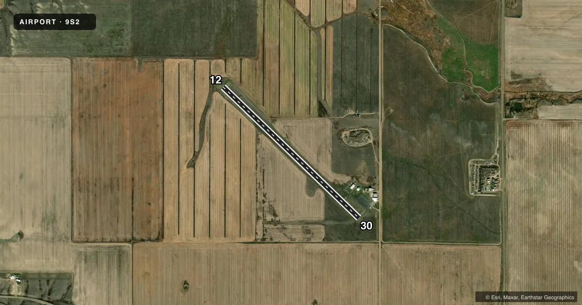
Airport sketch
Runways drawn to scale from FAA survey coordinates, rendered over satellite imagery. Not for navigation.
Approaches & charts
Services on the field
Fuel grades, oxygen, maintenance, ramp storage and lighting — as declared to the FAA by the airport operator.
Fuel & services
- Fuel
- 100LLA
- Oxygen (bottled)
- Not available
- Oxygen (bulk)
- Not available
- Airframe repair
- Major
- Power plant repair
- Major
- Other services
- AGRI,CHTR
Ramp & ground
- Transient storage
- Tie-down
- Hangar
- Landing fee
- No fee published
- Customs
- Not available
- Lighting schedule
- SEE RMK
- Beacon schedule
- SS-SR
- Beacon
- White / Green (civil land)(WG)
- Wind indicator
- Lighted
- Segmented circle
- Yes
Fuel & FBOs
Cheapest 100LL and Jet A on the field and nearby. Always confirm with the FBO before taxi.
Airport notes
Surface conditions, obstructions, local procedures, lighting outages and other notes published with each FAA cycle.
General notes
- DEER ON & INVOF ARPT.
- FOR CD CTC SALT LAKE ARTCC AT 801-320-2568.
Lighting notes
- MIRL RY 12/30 & PAPI RY 12 & 30 OPER DUSK-2300; AFT 2300 ACTVT - CTAF.
Other notes
- AUTOMATED UNICOM.
VFR map & nearby airports
VFR sectional. Tap any ICAO chip to open that airport.
Key facts · 9S2
Answer card- ICAO
- 9S2
- Name
- SCOBEY
- Location
- SCOBEY, MONTANA
- Elevation
- 2,434 ft MSL
- Traffic pattern altitude
- 3,434 ft MSL (1,000 AGL)
- Control tower
- Non-towered (use CTAF)
- Total runways
- 1
- Longest runway
- 12/30 · 4,020 ft
- Published ILS approaches
- 0
- Published frequencies
- 2
- Magnetic variation
- 12°
- Current flight rules
- VFR
- Current wind
- 300° at 13 kt
- Favored runway now
- RWY 30
Scobey Airport sits in Scobey, Montana at 2,434 ft MSL. It has one runway, 12/30, which is 4,020 ft of asphalt. The field is not towered. CTAF and UNICOM are both 122.8. No ILS approaches are published here.
Pattern altitude is not published, so use the current FAA Chart Supplement before you fly the pattern. The airport sits in open country near the Canadian border. Deer are reported on and near the airport, so keep a sharp scan on taxi, takeoff and landing. Runway 12/30 has medium intensity lighting. The PAPI on both ends runs from dusk to 2300. After 2300, light activation is by CTAF. For clearance delivery, contact Salt Lake ARTCC at 801-320-2568.
Trower Aviation is on the field. It carries AVGAS 100LL and Jet A. If you need current airport details before departure, verify the latest notes with the airport operator or the FBO directly by phone.