METAR & TAF 9A5
9A5 does not publish a METAR.
Showing the nearest reporting station: KDNN (DALTON MUNI) · 20.8 NM away. Conditions at 9A5 may differ.
METAR · KDNN
Observed 05:15Z
KDNN 120515Z AUTO 00000KT 10SM CLR 24/24 A3002 RMK AO2 T02400240
- Wind
- 000° @ 0 kt
- Visibility
- 10 SM
- Temp / Dew
- 24°C / 24°C
- Altimeter
- 30.02 inHg
- Clouds
- CLR
- Density alt
- 1,919 ft
- Ceiling
- Unlimited
- Rules
- VFR
Airport info & contacts
Manager on record, flight service, ARTCC, attendance schedule and pattern altitude — published by the FAA and refreshed every 28 days.
Location
- From city
- 1 NM S
- VFR sectional
- ATLANTA
- ARTCC
- ZTL · ATLANTA
- NOTAM facility
- MCN (NOTAM-D)
Airport manager
- Name
- VERNON BARNETT
- Phone
- (706) 638-7071
- Address
- 141 GASQUE DR, LAFAYETTE GA 30728
Flight service · Hours
- FSS MCN
- MACON1-800-WX-BRIEF
- Attendance
- MON-FRI · 0900-1700
Frequencies
Tap any row to copy the frequency to your clipboard.
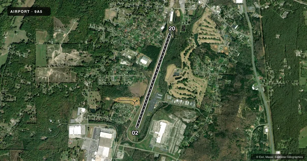
Runways & pattern
Full pagePattern entry · RWY 02
LEFT TRAFFICRunway end performance
| End | TORA | TODA | ASDA | LDA | VGSI | Approach lights | Obstruction |
|---|---|---|---|---|---|---|---|
| 02 | 4,999' | 4,999' | 4,999' | 4,086' | — | — | 37', trees, 311' from thr, 264' R of cntrln, slope 3 |
| 20 | 4,999' | 4,999' | 4,999' | 4,740' | — | — | 32', bldg, 620' from thr, 157' R of cntrln, slope 13 |
Declared distances in feet. TORA = takeoff run available, TODA = takeoff distance, ASDA = accelerate-stop, LDA = landing distance.
Airport sketch
Runways drawn to scale from FAA survey coordinates, rendered over satellite imagery. Not for navigation.
Approaches & charts
Services on the field
Fuel grades, oxygen, maintenance, ramp storage and lighting — as declared to the FAA by the airport operator.
Fuel & services
- Fuel
- 100LL
- Oxygen (bottled)
- HIGH/LOW
- Oxygen (bulk)
- Not available
- Airframe repair
- Major
- Power plant repair
- Major
- Other services
- INSTR
Ramp & ground
- Transient storage
- Tie-down
- Landing fee
- No fee published
- Customs
- Not available
- Lighting schedule
- SEE RMK
- Beacon schedule
- SS-SR
- Beacon
- White / Green (civil land)(WG)
- Wind indicator
- Lighted
- Segmented circle
- Yes
Fuel & FBOs
Cheapest 100LL and Jet A on the field and nearby. Always confirm with the FBO before taxi.
Airport notes
Surface conditions, obstructions, local procedures, lighting outages and other notes published with each FAA cycle.
General notes
- RR TR PARL W SIDE OF RWY 150 FT FM CNTRLN.
- DEER AND OTHER WILDLIFE ON & INVOF RWY & ARPT.
- FOR CD CTC CHATTANOOGA APCH AT 423-855-6478, WHEN APCH CLSD CTC ATLANTA ARTCC AT 770-210-7692.
Lighting notes
- MIRL RWY 02/20 PRESET MED INTST. TO INCR INTST & ACTVT MIRL RWY 02/20 - CTAF.
Approach & departure obstructions
- 20RR TR AS CLOSE AS 184 FT RIGHT
- 200:1 AT DSPLCD THLD - RR TR 157 FT RIGHT.
Other notes
- EXISTED PRIOR TO 1959.
VFR map & nearby airports
VFR sectional. Tap any ICAO chip to open that airport.
Key facts · 9A5
Answer card- ICAO
- 9A5
- Name
- BARWICK LAFAYETTE
- Location
- LAFAYETTE, GEORGIA
- Elevation
- 776.4 ft MSL
- Traffic pattern altitude
- 1,776.4 ft MSL (1,000 AGL)
- Control tower
- Non-towered (use CTAF)
- Total runways
- 1
- Longest runway
- 02/20 · 4,999 ft
- Published ILS approaches
- 0
- Published frequencies
- 4
- Magnetic variation
- 3°
- Current flight rules
- VFR
- Current wind
- 000° at 0 kt
- Favored runway now
- –
Barwick Lafayette Airport (9A5) is in Lafayette, Georgia. The field elevation is 776.4 ft MSL. It has one runway, 02/20, which is 4,999 ft long and asphalt. There is no control tower. No ILS approaches are published. Pattern altitude is not published in the facts, so verify the current Chart Supplement before you go. The airport sits near Chattanooga approach coverage, with clearance delivery handled through Chattanooga Approach when it is open.
Barwick-Lafayette Airport is the on-field FBO. It carries AVGAS 100LL. Call ahead at (706) 638-7071 for current service details. The runway edge lights on 02/20 are preset to medium intensity. Use CTAF to increase intensity and activate them. The published remarks also call out railroad tracks close to the runway, including a track along the west side and another near runway 20. That makes a careful look at the runway environment a good idea on arrival and departure.
This is a non-towered field with wildlife reported on and near the airport. Expect normal self-announce operations on CTAF 122.8. If you need current noise, curfew, or local operating details, check the current FAA Chart Supplement or call the airport operator directly before launch.