METAR & TAF 6D9
6D9 does not publish a METAR.
Showing the nearest reporting station: KOSC (OSCODA/WURTSMITH) · 8.4 NM away. Conditions at 6D9 may differ.
METAR · KOSC
Observed 09:15Z
KOSC 260915Z AUTO 32007KT 10SM SCT035 OVC050 14/13 A3002 RMK AO2
- Wind
- 320° @ 7 kt
- Visibility
- 10 SM
- Temp / Dew
- 14°C / 13°C
- Altimeter
- 30.02 inHg
- Clouds
- OVC
- Density alt
- 507 ft
- Ceiling
- 5,000 ft AGL
- Rules
- VFR
Airport info & contacts
Manager on record, flight service, ARTCC, attendance schedule and pattern altitude — published by the FAA and refreshed every 28 days.
Location
- From city
- 3 NM NE
- VFR sectional
- LAKE HURON
- ARTCC
- ZMP · MINNEAPOLIS
- NOTAM facility
- LAN (NOTAM-D)
Airport manager
- Name
- JAY SAMUELS
- Phone
- 989-305-0126
- Address
- 1131 AULERICH RD, EAST TAWAS MI 48730-9565
Flight service · Hours
- FSS LAN
- LANSING1-800-WX-BRIEF
- Attendance
- MON-FRI · IREG
- SUN · ON CALL
Frequencies
Tap any row to copy the frequency to your clipboard.
Runways & pattern
Full pagePattern entry · RWY 26
LEFT TRAFFICRunway end performance
| End | TORA | TODA | ASDA | LDA | VGSI | Approach lights | Obstruction |
|---|---|---|---|---|---|---|---|
| 08 | — | — | — | — | PAPI 2-box left(3°) | — | 12', tree, 421' from thr, 270' R of cntrln, slope 18 |
| 26 | — | — | — | — | PAPI 2-box left(3°) | — | 34', tree, 363' from thr, 278' R of cntrln, slope 4 |
Declared distances in feet. TORA = takeoff run available, TODA = takeoff distance, ASDA = accelerate-stop, LDA = landing distance.
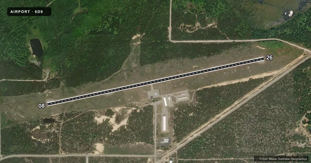
Airport sketch
Runways drawn to scale from FAA survey coordinates, rendered over satellite imagery. Not for navigation.
Approaches & charts
Services on the field
Fuel grades, oxygen, maintenance, ramp storage and lighting — as declared to the FAA by the airport operator.
Fuel & services
- Fuel
- 100LL
- Oxygen (bottled)
- Not available
- Oxygen (bulk)
- Not available
- Airframe repair
- Not available
- Power plant repair
- Not available
Ramp & ground
- Transient storage
- Tie-down
- Landing fee
- No fee published
- Customs
- Not available
- Lighting schedule
- SEE RMK
- Beacon schedule
- SS-SR
- Beacon
- White / Green (civil land)(WG)
- Wind indicator
- Lighted
- Segmented circle
- Yes
Fuel & FBOs
Cheapest 100LL and Jet A on the field and nearby. Always confirm with the FBO before taxi.
Airport notes
Surface conditions, obstructions, local procedures, lighting outages and other notes published with each FAA cycle.
General notes
- DEER & LRG BIRDS ON & INVOF ARPT.
- FOR CD CTC MINNEAPOLIS ARTCC AT 651-463-5588.
Lighting notes
- ACTVT REIL RWY 08 & 26; PAPI RWY 08 & 26; MIRL RWY 08/26 - 122.85.
Other notes
- 3FOR SVC CALL AMGR.
VFR map & nearby airports
VFR sectional. Tap any ICAO chip to open that airport.
Key facts · 6D9
Answer card- ICAO
- 6D9
- Name
- IOSCO COUNTY
- Location
- EAST TAWAS, MICHIGAN
- Elevation
- 605.3 ft MSL
- Traffic pattern altitude
- 1,605.3 ft MSL (1,000 AGL)
- Control tower
- Non-towered (use CTAF)
- Total runways
- 1
- Longest runway
- 08/26 · 4,802 ft
- Published ILS approaches
- 0
- Published frequencies
- 2
- Magnetic variation
- 8°
- Current flight rules
- VFR
- Current wind
- 320° at 7 kt
- Favored runway now
- RWY 26
Iosco County Airport is in East Tawas, Michigan. The field elevation is 605.3 ft MSL. It has one runway, 08/26, which is 4,802 ft long and asphalt. The airport is not towered. CTAF and UNICOM are both 122.8. The runway headings are 78° and 258° magnetic.
No ILS approaches are published here. Pattern altitude is not published, so use the standard 1,000 ft AGL for light piston traffic unless the current Chart Supplement says otherwise. The on-field FBO is Iosco County Airport. It carries AVGAS 100LL. Call (989) 362-0052 for service.
A few operational notes matter here. Deer and large birds are reported on and near the airport. That is worth keeping in mind on taxi, takeoff and final. Runway 08 and 26 have runway end identifier lights, precision approach path indicators and medium intensity runway lighting. The remarks also say to contact frequency 122.85 for lighting activation. For clearance delivery, contact Minneapolis ARTCC at 651-463-5588. If you are planning a first arrival, verify current procedures with the airport manager or the current FAA Chart Supplement before you go.