METAR & TAF 4I3
Current METAR
Observed 23:35Z
K4I3 272335Z AUTO 21004KT 10SM CLR 25/24 A2982 RMK AO2 LTG DSNT W
- Wind
- 210° @ 4 kt
- Visibility
- 10 SM
- Temp / Dew
- 25°C / 24°C
- Altimeter
- 29.82 inHg
- Clouds
- CLR
- Density alt
- 2,802 ft
- Ceiling
- Unlimited
- Rules
- VFR
Airport info & contacts
Manager on record, flight service, ARTCC, attendance schedule and pattern altitude — published by the FAA and refreshed every 28 days.
Location
- From city
- 4 NM SW
- VFR sectional
- DETROIT
- Pattern altitude
- 808 ft AGL · 2,000 ft MSL
- ARTCC
- ZID · INDIANAPOLIS
- NOTAM facility
- 4I3 (NOTAM-D)
Airport manager
- Name
- JOSH WYNN
- Phone
- 740-397-9647
- Address
- 6481 KINNEY RD, MOUNT VERNON OH 43050-9301
Flight service · Hours
- FSS CLE
- CLEVELAND1-800-WX-BRIEF
- Attendance
- MON-FRI · 0700-1700
- SAT-SUN · 0900-1700
Frequencies
Tap any row to copy the frequency to your clipboard.
Runways & pattern
Full pagePattern entry · RWY 28
LEFT TRAFFICRunway end performance
| End | TORA | TODA | ASDA | LDA | VGSI | Approach lights | Obstruction |
|---|---|---|---|---|---|---|---|
| 10 | — | — | — | — | PAPI 4-box left(3°) | — | 126', trees, 3188' from thr, 60' R of cntrln, slope 23 |
| 28 | — | — | — | — | PAPI 4-box left(3°) | — | 51', trees, 1962' from thr, 65' R of cntrln, slope 34 |
Declared distances in feet. TORA = takeoff run available, TODA = takeoff distance, ASDA = accelerate-stop, LDA = landing distance.
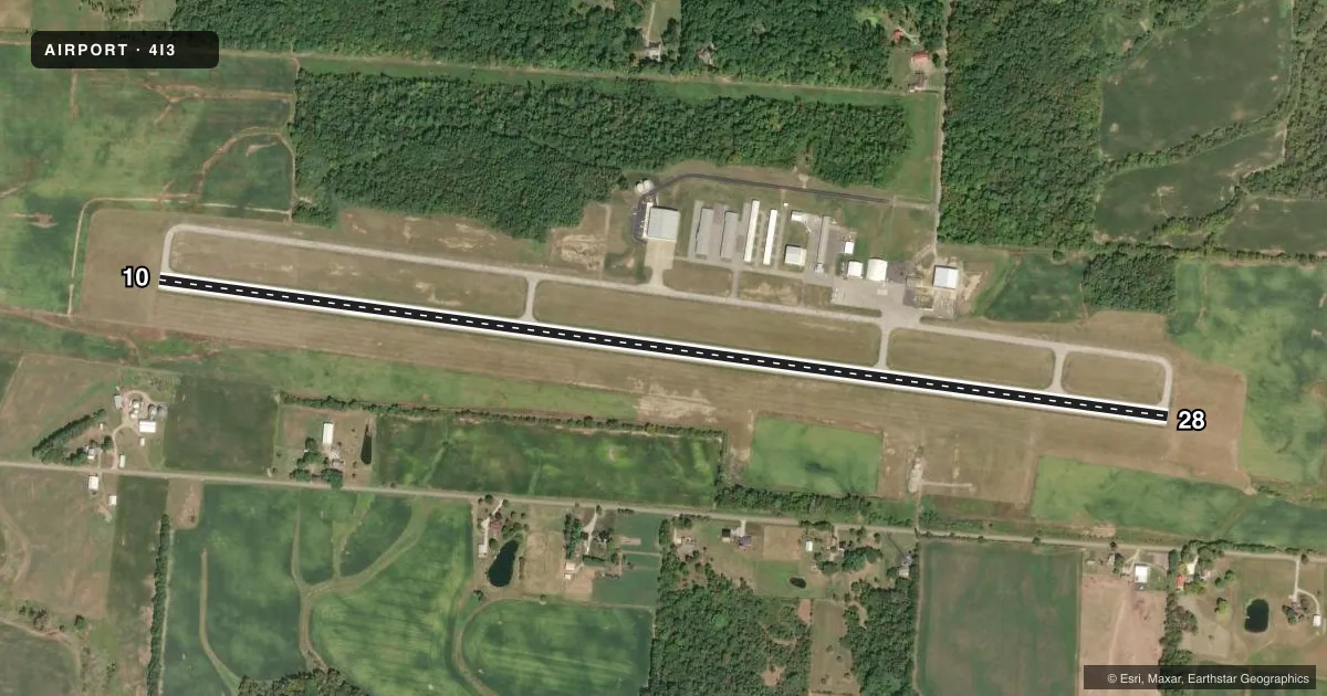
Airport sketch
Runways drawn to scale from FAA survey coordinates, rendered over satellite imagery. Not for navigation.
Approaches & charts
Services on the field
Fuel grades, oxygen, maintenance, ramp storage and lighting — as declared to the FAA by the airport operator.
Fuel & services
- Fuel
- 100LLA+
- Oxygen (bottled)
- Not available
- Oxygen (bulk)
- Not available
- Airframe repair
- Major
- Power plant repair
- Major
- Other services
- AGRI,INSTR,RNTL
Ramp & ground
- Transient storage
- Tie-down
- Hangar
- Landing fee
- No fee published
- Customs
- Not available
- Lighting schedule
- SEE RMK
- Beacon schedule
- SS-SR
- Beacon
- White / Green (civil land)(WG)
- Wind indicator
- Lighted
- Segmented circle
- No
Fuel & FBOs
Cheapest 100LL and Jet A on the field and nearby. Always confirm with the FBO before taxi.
Airport notes
Surface conditions, obstructions, local procedures, lighting outages and other notes published with each FAA cycle.
General notes
- DEER, BIRDS, & OTR WILDLIFE ON & INVOF ARPT.
Lighting notes
- ACTVT REIL RWY 10 & 28; MIRL RWY 10/28 - CTAF. PAPI RWY 10 & 28 OPR CONSLY.
Fuel notes
- 100LLFUEL AVBL H24 SELF SER VIA CREDIT CARD.
Other notes
- 124 HR PN FOR ATNDNC AFT HRS - CALL AMGR.
- MANAGERKNOXAIRPORT@EMBARQMAIL.COM.
VFR map & nearby airports
VFR sectional. Tap any ICAO chip to open that airport.
Key facts · 4I3
Answer card- ICAO
- 4I3
- Name
- KNOX COUNTY
- Location
- MOUNT VERNON, OHIO
- Elevation
- 1,191.6 ft MSL
- Traffic pattern altitude
- 1,999.6 ft MSL (808 AGL)
- Control tower
- Non-towered (use CTAF)
- Total runways
- 1
- Longest runway
- 10/28 · 5,504 ft
- Published ILS approaches
- 0
- Published frequencies
- 5
- Magnetic variation
- 6°
- Current flight rules
- VFR
- Current wind
- 210° at 4 kt
- Favored runway now
- RWY 28
Knox County Airport sits in Mount Vernon, Ohio. The field elevation is 1,191.6 ft MSL. It has one runway. Runway 10/28 is 5,504 ft long with asphalt pavement. The airport is non-towered. The pattern altitude is 808 ft AGL, which is 1,999.6 ft MSL.
There are no ILS approaches published here. Pilots coming in should plan with the current FAA Chart Supplement and the Columbus approach frequencies in mind. The airport uses CTAF 123.05. UNICOM is also 123.05. The published approach and departure frequencies are 125.95 and 317.775 for Columbus.
The on-field FBO is Knox County Airport. It carries 100LL and Jet A with Prist. 100LL is available 24 hours self-serve by credit card. Runway end identifier lights are on runways 10 and 28. Medium intensity runway lights are also on 10 and 28. They are controlled by CTAF. The PAPI on both ends operates continuously.
For a first-time arrival, watch for wildlife. Deer, birds and other wildlife are reported on and near the airport. After-hours attendance requires 24-hour prior notice. Call the airport manager before planning anything outside normal support. The airport manager can also be reached at knoxairport@embarqmail.com.