METAR & TAF 33N
Current METAR
Observed 06:35Z
K33N 120635Z AUTO 26005KT 10SM 23/22 A2979 RMK A01
- Wind
- 260° @ 5 kt
- Visibility
- 10 SM
- Temp / Dew
- 23°C / 22°C
- Altimeter
- 29.79 inHg
- Clouds
- Clear
- Density alt
- 1,190 ft
- Ceiling
- Unlimited
- Rules
- VFR
Airport info & contacts
Manager on record, flight service, ARTCC, attendance schedule and pattern altitude — published by the FAA and refreshed every 28 days.
Location
- From city
- 1 NM W
- VFR sectional
- WASHINGTON
- ARTCC
- ZDC · WASHINGTON
- NOTAM facility
- MIV (NOTAM-D)
Airport manager
- Name
- BRENDEN O. BOND
- Phone
- 609-231-0428
- Address
- 189 W DURHAM LANE, DOVER DE 19904
Flight service · Hours
- FSS MIV
- MILLVILLE1-800-WX-BRIEF
- Attendance
- 0830-1630
Frequencies
Tap any row to copy the frequency to your clipboard.
Runways & pattern
Full pagePattern entry · RWY 27
LEFT TRAFFICRunway end performance
| End | TORA | TODA | ASDA | LDA | VGSI | Approach lights | Obstruction |
|---|---|---|---|---|---|---|---|
| 09 | — | — | — | — | PAPI 2-box left(3°) | — | — |
| 27 | — | — | — | — | PAPI 2-box left(3°) | — | — |
Declared distances in feet. TORA = takeoff run available, TODA = takeoff distance, ASDA = accelerate-stop, LDA = landing distance.
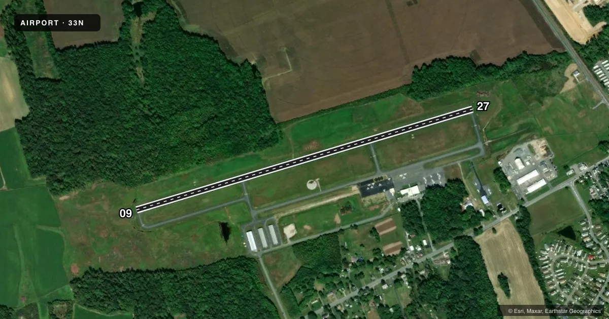
Airport sketch
Runways drawn to scale from FAA survey coordinates, rendered over satellite imagery. Not for navigation.
Approaches & charts
Services on the field
Fuel grades, oxygen, maintenance, ramp storage and lighting — as declared to the FAA by the airport operator.
Fuel & services
- Fuel
- 100LL
- Oxygen (bottled)
- Not available
- Oxygen (bulk)
- Not available
- Airframe repair
- Not available
- Power plant repair
- Not available
- Other services
- AGRI,INSTR,RNTL
Ramp & ground
- Transient storage
- Not published
- Customs
- Not available
- Lighting schedule
- SEE RMK
- Beacon schedule
- SS-SR
- Beacon
- White / Green (civil land)(WG)
- Wind indicator
- Lighted
- Segmented circle
- Yes
Fuel & FBOs
Cheapest 100LL and Jet A on the field and nearby. Always confirm with the FBO before taxi.
Airport notes
Surface conditions, obstructions, local procedures, lighting outages and other notes published with each FAA cycle.
General notes
- ACFT UN OPS DUE TO SIZE OR FAC ALTN IS DOVER AFB CIV AIR TRML, PPR RQR (302) 571- 6375.
- DEER AND BIRDS ON AND INVOF ARPT.
- MOWING OPS CONDUCTED 0700-1500 APR-OCT.
- ARPT CONDS UNMON BTN 1630-0830.
- ACFT NOT VISIBLE ON OPPOSITE END OF RWY DUE TO GRADIENT.
- FOR CD CTC WASHINGTON ARTCC AT 703-771-3587.
- SGFNT FIXED WING AND HELI ACFT FLT TRG INVOF AIRPARK.
- TRAN ACFT PRKG N TRML BLDG. ADDNLTRAN PRKG ON APN W OF T HNGRS. E APN CLSD TO TRAN ACFT PRKG.
Lighting notes
- ACTVT REIL RWY 09 & 27; MIRL RWY 09/27 - CTAF .
Fuel notes
- 100LL24 HR SELF-SERVICE CREDIT CARD FUEL AVBL.
Approach & departure obstructions
- 27CALM WIND RWY.
- 0994 FT TREE 0.3 NM WEST OF RWY.
- 2757 FT PWR LN 0.2 NM EAST OF RWY.
VFR map & nearby airports
VFR sectional. Tap any ICAO chip to open that airport.
Key facts · 33N
Answer card- ICAO
- 33N
- Name
- DELAWARE AIRPARK
- Location
- DOVER/CHESWOLD, DELAWARE
- Elevation
- 55.2 ft MSL
- Traffic pattern altitude
- 1,055.2 ft MSL (1,000 AGL)
- Control tower
- Non-towered (use CTAF)
- Total runways
- 1
- Longest runway
- 09/27 · 4,201 ft
- Published ILS approaches
- 0
- Published frequencies
- 5
- Magnetic variation
- 12°
- Current flight rules
- VFR
- Current wind
- 260° at 5 kt
- Favored runway now
- RWY 27
Delaware Airpark sits in Dover and Cheswold, Delaware. Field elevation is 55.2 ft MSL. It has one runway, 09/27, which is 4,201 ft long and paved with asphalt. The airport is non-towered. The runway lights are medium intensity and controlled by CTAF. Runway end identifier lights are active on both ends. No ILS approaches are published here.
Pattern altitude is not published. Use the standard 1,000 ft AGL for light piston traffic unless the current Chart Supplement says otherwise. Runway 27 is the calm wind runway. That is useful here because the field has a gradient. Aircraft are not visible on the opposite end of the runway because of that slope. Keep a close scan on rollout and backtaxi operations. There is also a 94-foot tree 0.3 NM west of the runway on the 09 side. A 57-foot power line sits 0.2 NM east of the runway on the 27 side.
Delaware Airpark has one on-field FBO, Delaware Airpark. It carries 100LL. Twenty-four hour self-serve credit card fuel is available. Airport conditions are unmonitored between 1630 and 0830. Deer and birds are reported on and near the airport. Transient parking is north of the terminal building. Additional transient parking is on the apron west of the T hangars. The east apron is closed to transient parking. For clearance delivery, contact Washington ARTCC. If your aircraft is too large for the field, use Dover Air Force Base civilian air terminal with prior permission.