METAR & TAF 2T1
2T1 does not publish a METAR.
Showing the nearest reporting station: KCVN (CLOVIS RGNL) · 26.1 NM away. Conditions at 2T1 may differ.
METAR · KCVN
Observed 18:56Z
KCVN 271856Z AUTO 19008KT 10SM CLR 37/14 A3005 RMK AO2 SLP115 T03670144 PNO $
- Wind
- 190° @ 8 kt
- Visibility
- 10 SM
- Temp / Dew
- 37°C / 14°C
- Altimeter
- 30.05 inHg
- Clouds
- CLR
- Density alt
- 7,165 ft
- Ceiling
- Unlimited
- Rules
- VFR
Airport info & contacts
Manager on record, flight service, ARTCC, attendance schedule and pattern altitude — published by the FAA and refreshed every 28 days.
Location
- From city
- 4 NM SE
- VFR sectional
- ALBUQUERQUE
- ARTCC
- ZFW · FORT WORTH
- NOTAM facility
- FTW (NOTAM-D)
Airport manager
- Name
- RAMON SANCHEZ
- Phone
- 806-272-4528
- Address
- 215 S FIRST ST, MULESHOE TX 79347
Flight service · Hours
- FSS FTW
- FORT WORTH1-800-WX-BRIEF
- Attendance
- Unattended
Frequencies
Tap any row to copy the frequency to your clipboard.
Runways & pattern
Full pagePattern entry · RWY 25
LEFT TRAFFICRunway end performance
| End | TORA | TODA | ASDA | LDA | VGSI | Approach lights | Obstruction |
|---|---|---|---|---|---|---|---|
| 07 | — | — | — | — | PAPI 2-box left(3°) | — | 54', pole, 1356' from thr, 0' R of cntrln, slope 21 |
| 25 | — | — | — | — | PAPI 2-box left(3°) | — | — |
Declared distances in feet. TORA = takeoff run available, TODA = takeoff distance, ASDA = accelerate-stop, LDA = landing distance.
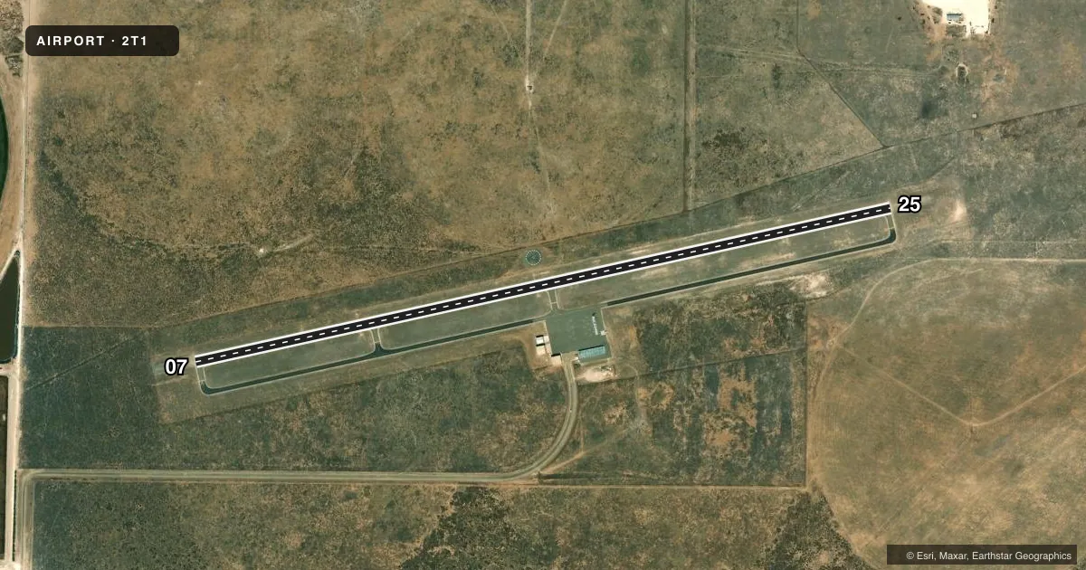
Airport sketch
Runways drawn to scale from FAA survey coordinates, rendered over satellite imagery. Not for navigation.
Approaches & charts
Services on the field
Fuel grades, oxygen, maintenance, ramp storage and lighting — as declared to the FAA by the airport operator.
Fuel & services
- Fuel
- 100LL
Ramp & ground
- Transient storage
- Tie-down
- Lighting schedule
- SEE RMK
- Beacon schedule
- SS-SR
- Beacon
- White / Green (civil land)(WG)
- Wind indicator
- Lighted
- Segmented circle
- Yes
Fuel & FBOs
Cheapest 100LL and Jet A on the field and nearby. Always confirm with the FBO before taxi.
Airport notes
Surface conditions, obstructions, local procedures, lighting outages and other notes published with each FAA cycle.
General notes
- DEER ON & INVOF ARPT.
- FOR CD CTC FORT WORTH ARTCC AT 817-858-7584.
Lighting notes
- ACTVT PAPI RWY 07 & 25; MIRL RWY 07/25 - 122.8.
Fuel notes
- 100LLFUEL 24 HR SELF SERVE. FOR EMERGENCY FUEL CALL CENTRAL DISPATCH 806-272-4569.
Other notes
- THIS AIRPORT HAS BEEN SURVEYED BY THE NATIONAL GEODETIC SURVEY.
- MANAGERCITY/ARPT MGR
VFR map & nearby airports
VFR sectional. Tap any ICAO chip to open that airport.
Key facts · 2T1
Answer card- ICAO
- 2T1
- Name
- MULESHOE MUNI
- Location
- MULESHOE, TEXAS
- Elevation
- 3,779.3 ft MSL
- Traffic pattern altitude
- 4,779.3 ft MSL (1,000 AGL)
- Control tower
- Non-towered (use CTAF)
- Total runways
- 1
- Longest runway
- 07/25 · 5,100 ft
- Published ILS approaches
- 0
- Published frequencies
- 1
- Magnetic variation
- 9°
- Current flight rules
- VFR
- Current wind
- 190° at 8 kt
- Favored runway now
- RWY 25
Muleshoe Muni sits in Muleshoe, Texas. The field elevation is 3,779.3 ft MSL. It has one runway. Runway 07/25 is 5,100 ft long with asphalt pavement. The airport is non-towered. CTAF is 122.9. The published remarks also note medium intensity lights on both runway ends. PAPI is available on 07 and 25. The lighting frequency is 122.8.
No ILS approaches are published here. Pattern altitude is not published, so use the standard 1,000 ft AGL for light piston ops unless the current Chart Supplement says otherwise. Deer are reported on and near the airport. That matters here because the field is out in open country. The elevation is already high enough to make density altitude a real planning item on warm days.
Muleshoe Municipal Airport is the on-field FBO. It carries AVGAS 100LL. Fuel is 24-hour self-serve. For emergency fuel, the published contact is Central Dispatch. For clearance delivery, contact Fort Worth ARTCC. If you are coming in for the first time, brief the runway lighting. Watch for wildlife. Verify any current airport notes before departure.