METAR & TAF 26N
26N does not publish a METAR.
Showing the nearest reporting station: KACY (ATLANTIC CITY INTL) · 11.7 NM away. Conditions at 26N may differ.
METAR · KACY
Observed 03:54Z
KACY 120354Z 31015G20KT 10SM CLR 28/21 A2978 RMK AO2 SLP082 T02830211
- Wind
- 310° @ 15G20 kt
- Visibility
- 10 SM
- Temp / Dew
- 28°C / 21°C
- Altimeter
- 29.78 inHg
- Clouds
- CLR
- Density alt
- 1,741 ft
- Ceiling
- Unlimited
- Rules
- VFR
Airport info & contacts
Manager on record, flight service, ARTCC, attendance schedule and pattern altitude — published by the FAA and refreshed every 28 days.
Location
- From city
- 2 NM SW
- VFR sectional
- WASHINGTON
- ARTCC
- ZDC · WASHINGTON
- NOTAM facility
- MIV (NOTAM-D)
Airport manager
- Name
- TODD DWYER
- Phone
- (609) 525-9222
- Address
- 26TH STREET & BAY AVENUE, OCEAN CITY NJ 08226
Flight service · Hours
- FSS MIV
- MILLVILLE1-800-WX-BRIEF
- Attendance
- JUN-SEP · 0800-1800
- WINTER · 0800-1600
Frequencies
Tap any row to copy the frequency to your clipboard.
Runways & pattern
Full pagePattern entry · RWY 24
RIGHT TRAFFICRunway end performance
| End | TORA | TODA | ASDA | LDA | VGSI | Approach lights | Obstruction |
|---|---|---|---|---|---|---|---|
| 06 | — | — | — | — | PAPI 2-box right(3.5°) | — | — |
| 24 | — | — | — | — | PAPI 2-box left(3.5°) | — | 16', tree, 200' from thr, 220' R of cntrln, slope 0 |
Declared distances in feet. TORA = takeoff run available, TODA = takeoff distance, ASDA = accelerate-stop, LDA = landing distance.
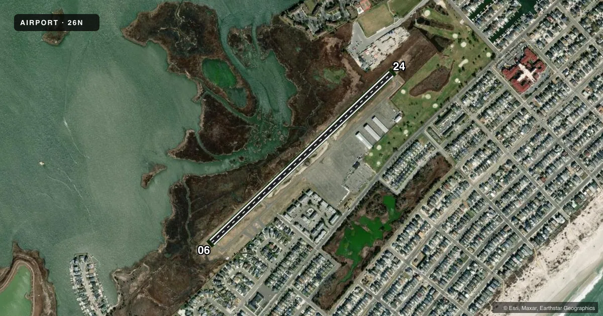
Airport sketch
Runways drawn to scale from FAA survey coordinates, rendered over satellite imagery. Not for navigation.
Approaches & charts
Services on the field
Fuel grades, oxygen, maintenance, ramp storage and lighting — as declared to the FAA by the airport operator.
Fuel & services
- Fuel
- 100LL
- Oxygen (bottled)
- Not available
- Oxygen (bulk)
- Not available
- Airframe repair
- Not available
- Power plant repair
- Not available
Ramp & ground
- Transient storage
- Tie-down
- Hangar
- Landing fee
- No fee published
- Customs
- Not available
- Lighting schedule
- SEE RMK
- Wind indicator
- Lighted
- Segmented circle
- Yes
Fuel & FBOs
Cheapest 100LL and Jet A on the field and nearby. Always confirm with the FBO before taxi.
Airport notes
Surface conditions, obstructions, local procedures, lighting outages and other notes published with each FAA cycle.
General notes
- BIRDS ON AND INVOF ARPT.
- FOR CD CTC WASHINGTON ARTCC AT 703-771-3587.
Lighting notes
- ACTVT MIRL RY 06/24 - CTAF.
VFR map & nearby airports
VFR sectional. Tap any ICAO chip to open that airport.
Key facts · 26N
Answer card- ICAO
- 26N
- Name
- OCEAN CITY MUNI
- Location
- OCEAN CITY, NEW JERSEY
- Elevation
- 5.7 ft MSL
- Traffic pattern altitude
- 1,005.7 ft MSL (1,000 AGL)
- Control tower
- Non-towered (use CTAF)
- Total runways
- 1
- Longest runway
- 06/24 · 2,972 ft
- Published ILS approaches
- 0
- Published frequencies
- 5
- Magnetic variation
- 13°
- Current flight rules
- VFR
- Current wind
- 310° at 15 kt
- Favored runway now
- RWY 24
Ocean City Muni (26N) sits in Ocean City, New Jersey. Field elevation is 5.7 ft MSL. The airport has one runway, 06/24, which is 2,972 ft long. There is no control tower. Pattern altitude is not published, so use the standard 1,000 ft AGL for light piston operations unless the current Chart Supplement says otherwise. That puts the pattern at about 1,006 ft MSL based on the listed field elevation.
No ILS approaches are published here. CTAF and UNICOM are both 122.7. Atlantic City handles approach and departure on 124.6 and 327.125. Clearance delivery is 133.6. The on-field FBO is Ocean City Municipal Airport. It carries 100LL. Call (609) 399-0907 before arrival if you need current service details.
A few operational points matter here. Birds are reported on and near the airport, so keep a sharp scan on arrival and departure. Medium intensity runway lights on 06/24 are activated by using the CTAF. That helps for night use, but you still need to plan for a non-towered field with no published ILS. If you need clearance on the ground, the published remark says to contact Washington ARTCC at 703-771-3587.